Պատկեր:Cyprus_districts_named.png
From Wikipedia, the free encyclopedia
Ավելի բարձր կետաչափով տարբերակ չկա։
Cyprus_districts_named.png (600 × 365 փիքսել, նիշքի չափը՝ 22 ԿԲ, MIME-տեսակը՝ image/png)
Այս նիշքը տեղադրված է Վիքիպահեստում է և այն կարող է օգտագործվել այլ նախագծերի կողմից։ Վիքիպահեստում նիշքի մասին տեղեկությունների հիմնական մասը ներկայացված է ստորև։

|
This map image could be re-created using vector graphics as an SVG file. This has several advantages; see Commons:Media for cleanup for more information. If an SVG form of this image is available, please upload it and afterwards replace this template with
{{vector version available|new image name}}.
It is recommended to name the SVG file “Cyprus districts named.svg”—then the template Vector version available (or Vva) does not need the new image name parameter. |
Ամփոփում
| ՆկարագրումCyprus districts named.png |
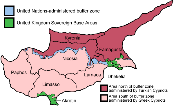
English: Map of the districts of Cyprus, named in English, with English annotations, and showing the Turkish Republic of Northern Cyprus, United Kingdom Sovereign Base Areas, and United Nations buffer zone. The individual maps see below.
Deutsch: Karte der Distrikte Zyperns: Bezirke der Republik Zypern, Türkische Republik Nordzypern, UK-Militärbasen, UN-Pufferzone (englische Beschriftung). Zu den Einzelkarten siehe unten "Individual maps". |
| Թվական | |
| Աղբյուր | Բեռնողի սեփական աշխատանք (traced from public domain UN or CIA maps.) |
| Հեղինակ | Golbez |
| Այլ մեկնակերպներ |
Français : File:Carte des districts de Chypre.png
Ελληνικά: File:Cyprus districts named el.png
|
Արտոնագրում
Ես, այս աշխատանքի հեղինակային իրավունքների տերը, ներկա հրատարակում եմ սրա հետևյալ լիցենզիաների պայմաններով
This file is licensed under the Creative Commons Attribution-Share Alike 2.5 Generic, 2.0 Generic and 1.0 Generic license.
- Դուք ազատ եք՝
- կիսվել ստեղծագործությամբ – պատճենել, տարածել և փոխանցել այս աշխատանքը։
- վերափոխել – ադապտացնել աշխատանքը
- Պահպանելով հետևյալ պայմանները'
- հղում – Դուք պետք է նշեք հեղինակի (իրավատիրոջ) հղումը:
- համանման տարածում – Եթե դուք ձևափոխում եք, փոխակերպում, կամ այս աշխատանքի հիման վրա ստեղծում եք նոր աշխատանք, ապա ձեր ստեղծածը կարող է տարածվել միայն նույն կամ համարժեք թույլատրագրով։

|
Այս վավերագրման պատճենահանման, տարածման և/կամ ձևափոխման թույլտվություն կամ լիցենզիայի GNU FDL պայմաններով 1.2 մեկնակերպի կամ ավելի ուշ, հրատարակված Ազատ ծրագրային ապահովության հիմնադրամում, առանց անփոփոխելի հատվածների, առանց բնագիրների, որոնք տեղադրված են առաջին և վերջին շապիկներում: Լիցենզիայի պատճենը գտնվում է GNU Free Documentation License հատվածում:http://www.gnu.org/copyleft/fdl.htmlGFDLGNU Free Documentation Licensetruetrue |
| Այս նիշքը հասանելի է Creative Commons Attribution-Share Alike 3.0 Unported արտոնագրի ներքո: | ||
| ||
| Այս արտոնգրության հատկանիշը ավելացված է տվյալ նիշքին որպես GFDL արտոնագրի բարեփոխում:http://creativecommons.org/licenses/by-sa/3.0/CC BY-SA 3.0Creative Commons Attribution-Share Alike 3.0truetrue |
Կարող եք ընտրել այս թույլատրագրերից ցանկացածը։
Individual maps of the Cyprus districts
Captions
Add a one-line explanation of what this file represents
Map with the island of Cyprus split into different administrative sections. (see legend)
A Ciprusi Köztársaság közigazgatási kerületei
Χάρτης του νησιού της Κύπρου διαχωρισμένο σε διαφορετικά διοικητικά τμήματα. (βλέπε υπόμνημα)
خريطة توضح مقاطعات قبرص باللغة الإنجليزية، وتظهر جمهورية قبرص، وجمهورية شمال قبرص التركية، ومناطق القواعد السيادية التابعة للمملكة المتحدة، والمنطقة العازلة الخاضعة لسيطرة الأمم المتحدة.
Items portrayed in this file
պատկերված
Հունիս 2005
image/png
checksum անգլերեն
2c30cef6aae2d3de01805aa236f469a70a50ee08
data size անգլերեն
22 511 Բայթ
365 փիքսել
600 փիքսել
Նիշքի պատմություն
Մատնահարեք օրվան/ժամին՝ նիշքի այդ պահին տեսքը դիտելու համար։
| Օր/Ժամ | Մանրապատկեր | Օբյեկտի չափը | Մասնակից | Մեկնաբանություն | |
|---|---|---|---|---|---|
| ընթացիկ | 20:38, 30 Մայիսի 2010 | | 600 × 365 (22 ԿԲ) | Wknight94 | Reverted to version as of 14:28, 13 August 2007 ---- latest upload with no new info on source, etc. |
| 23:46, 17 Նոյեմբերի 2008 |  | 700 × 482 (94 ԿԲ) | Guntars strazdins | {{Information |Description= |Source= |Date= |Author= |Permission= |other_versions= }} | |
| 23:44, 17 Նոյեմբերի 2008 |  | 700 × 482 (94 ԿԲ) | Guntars strazdins | {{Information |Description= |Source= |Date= |Author= |Permission= |other_versions= }} | |
| 14:28, 13 Օգոստոսի 2007 |  | 600 × 365 (22 ԿԲ) | Lexicon | Reverted to earlier revision | |
| 14:28, 13 Օգոստոսի 2007 |  | 600 × 365 (54 ԿԲ) | Lexicon | buffer zone and SBA colours flipped, since buffer zone is called the "Green Line" | |
| 06:07, 30 Հունիսի 2005 |  | 600 × 365 (22 ԿԲ) | Golbez | Got Dhekelia wrong again. Final version unless others have comments. | |
| 02:04, 28 Հունիսի 2005 |  | 600 × 365 (22 ԿԲ) | Golbez | Updated again, final version for now, cleaned up text and the Dhekelia area. | |
| 17:51, 27 Հունիսի 2005 |  | 600 × 365 (20 ԿԲ) | Golbez | Fixed a color | |
| 17:44, 27 Հունիսի 2005 |  | 600 × 365 (20 ԿԲ) | Golbez | Updated map with different color for north and south, and enclaves in Dhekelia. | |
| 09:48, 27 Հունիսի 2005 |  | 600 × 365 (19 ԿԲ) | Golbez | Map of the districts of Cyprus Source: Made by User:Golbez. {{cc-by-sa-2.0}} Category:Maps of Cyprus\ |
Նիշքի օգտագործում
Հետևյալ էջը հղվում է այս նիշքին՝
Նիշքի համընդհանուր օգտագործում
Հետևյալ այլ վիքիները օգտագործում են այս նիշքը՝
- Օգտագործումը af.wikipedia.org կայքում
- Օգտագործումը ar.wikipedia.org կայքում
- Օգտագործումը arz.wikipedia.org կայքում
- Օգտագործումը az.wikipedia.org կայքում
- Օգտագործումը az.wiktionary.org կայքում
- Օգտագործումը be.wikipedia.org կայքում
- Օգտագործումը bs.wikipedia.org կայքում
- Օգտագործումը ca.wikipedia.org կայքում
- Conflicte de Xipre
- Resolució 187 del Consell de Seguretat de les Nacions Unides
- Resolució 192 del Consell de Seguretat de les Nacions Unides
- Resolució 193 del Consell de Seguretat de les Nacions Unides
- Resolució 194 del Consell de Seguretat de les Nacions Unides
- Resolució 198 del Consell de Seguretat de les Nacions Unides
- Resolució 201 del Consell de Seguretat de les Nacions Unides
- Resolució 206 del Consell de Seguretat de les Nacions Unides
- Resolució 207 del Consell de Seguretat de les Nacions Unides
- Resolució 219 del Consell de Seguretat de les Nacions Unides
- Resolució 220 del Consell de Seguretat de les Nacions Unides
- Resolució 222 del Consell de Seguretat de les Nacions Unides
- Resolució 231 del Consell de Seguretat de les Nacions Unides
- Resolució 244 del Consell de Seguretat de les Nacions Unides
- Resolució 254 del Consell de Seguretat de les Nacions Unides
- Resolució 266 del Consell de Seguretat de les Nacions Unides
- Resolució 274 del Consell de Seguretat de les Nacions Unides
- Força de les Nacions Unides pel Manteniment de la Pau a Xipre
- Resolució 293 del Consell de Seguretat de les Nacions Unides
- Resolució 305 del Consell de Seguretat de les Nacions Unides
- Resolució 315 del Consell de Seguretat de les Nacions Unides
- Resolució 324 del Consell de Seguretat de les Nacions Unides
- Resolució 334 del Consell de Seguretat de les Nacions Unides
- Resolució 343 del Consell de Seguretat de les Nacions Unides
- Resolució 349 del Consell de Seguretat de les Nacions Unides
- Resolució 358 del Consell de Seguretat de les Nacions Unides
- Resolució 360 del Consell de Seguretat de les Nacions Unides
- Resolució 361 del Consell de Seguretat de les Nacions Unides
- Resolució 364 del Consell de Seguretat de les Nacions Unides
- Resolució 365 del Consell de Seguretat de les Nacions Unides
- Línia Verda (Xipre)
- Resolució 593 del Consell de Seguretat de les Nacions Unides
- Resolució 716 del Consell de Seguretat de les Nacions Unides
- Resolució 774 del Consell de Seguretat de les Nacions Unides
- Resolució 969 del Consell de Seguretat de les Nacions Unides
- Resolució 1475 del Consell de Seguretat de les Nacions Unides
- Resolució 1517 del Consell de Seguretat de les Nacions Unides
- Օգտագործումը ckb.wikipedia.org կայքում
Տեսնել այս նիշքի ավելի համընդհանուր օգտագործումը:
Ստացված է «https://hy.wikipedia.org/wiki/Պատկեր:Cyprus_districts_named.png» էջից