Պատկեր:Outre-mer_en_sans_Terre_Adelie.png
From Wikipedia, the free encyclopedia
Նախադիտման չափ՝ 800 × 342 պիքսել։ Այլ թույլտվությաններ: 320 × 137 պիքսել | 640 × 273 պիքսել | 1456 × 622 պիքսել.
Սկզբնական նիշք (1456 × 622 փիքսել, նիշքի չափը՝ 49 ԿԲ, MIME-տեսակը՝ image/png)
Այս նիշքը տեղադրված է Վիքիպահեստում է և այն կարող է օգտագործվել այլ նախագծերի կողմից։ Վիքիպահեստում նիշքի մասին տեղեկությունների հիմնական մասը ներկայացված է ստորև։
Ամփոփում

|
This locator map image could be re-created using vector graphics as an SVG file. This has several advantages; see Commons:Media for cleanup for more information. If an SVG form of this image is available, please upload it and afterwards replace this template with
{{vector version available|new image name}}.
It is recommended to name the SVG file “Outre-mer en sans Terre Adelie.svg”—then the template Vector version available (or Vva) does not need the new image name parameter. |
| ՆկարագրումOutre-mer en sans Terre Adelie.png |
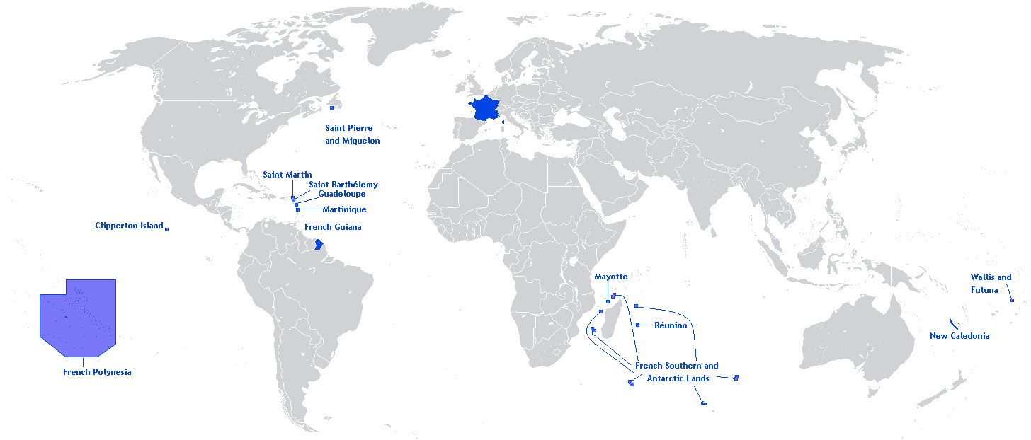
English: A map showing the Overseas departments and territories of France, excluding the territory of Adélie Land in Antarctica, where sovereignty is suspended |
| Թվական | |
| Աղբյուր | Բեռնողի սեփական աշխատանք |
| Հեղինակ | Originally Hoshie |
| Այլ մեկնակերպներ | Adapted from File:Outre-mer en.png |
English: This image is a cropped version of Image:Outre-mer en.png initally created by user Hoshie. Antarctica was cropped.
Արտոնագրում
Hoshie, սույն աշխատանքի հեղինակային իրավունքների տերը, այսուհետ այն հրատարակում է հետևյալ արտոնագրի պայմաններով՝

|
Այս վավերագրման պատճենահանման, տարածման և/կամ ձևափոխման թույլտվություն կամ լիցենզիայի GNU FDL պայմաններով 1.2 մեկնակերպի կամ ավելի ուշ, հրատարակված Ազատ ծրագրային ապահովության հիմնադրամում, առանց անփոփոխելի հատվածների, առանց բնագիրների, որոնք տեղադրված են առաջին և վերջին շապիկներում: Լիցենզիայի պատճենը գտնվում է GNU Free Documentation License հատվածում:http://www.gnu.org/copyleft/fdl.htmlGFDLGNU Free Documentation Licensetruetrue |
| Այս նիշքը հասանելի է Creative Commons Attribution-Share Alike 3.0 Unported արտոնագրի ներքո: | ||
| Հղում: Hoshie | ||
| ||
| Այս արտոնգրության հատկանիշը ավելացված է տվյալ նիշքին որպես GFDL արտոնագրի բարեփոխում:http://creativecommons.org/licenses/by-sa/3.0/CC BY-SA 3.0Creative Commons Attribution-Share Alike 3.0truetrue |
Captions
Add a one-line explanation of what this file represents
Items portrayed in this file
պատկերված
27 Մայիսի 2012
Նիշքի պատմություն
Մատնահարեք օրվան/ժամին՝ նիշքի այդ պահին տեսքը դիտելու համար։
| Օր/Ժամ | Մանրապատկեր | Օբյեկտի չափը | Մասնակից | Մեկնաբանություն | |
|---|---|---|---|---|---|
| ընթացիկ | 20:26, 27 Մարտի 2018 | | 1456 × 622 (49 ԿԲ) | Maphobbyist | Upload |
| 12:01, 27 Մայիսի 2012 |  | 1456 × 622 (59 ԿԲ) | Hazhk | Changing color | |
| 20:47, 12 փետրվարի 2012 |  | 1480 × 625 (68 ԿԲ) | Spesh531 | same as File:Outre-mer en.png, without Antarctica | |
| 00:35, 21 Հոկտեմբերի 2010 |  | 1431 × 655 (54 ԿԲ) | Rosss | Better view of French Polynesia | |
| 21:23, 25 Նոյեմբերի 2009 |  | 1431 × 655 (30 ԿԲ) | The Illusional Ministry | removed borer from french polynesia | |
| 21:22, 25 Նոյեմբերի 2009 |  | 1431 × 655 (30 ԿԲ) | The Illusional Ministry | ||
| 03:31, 17 Դեկտեմբերի 2007 |  | 1431 × 655 (35 ԿԲ) | Rosss | Wider margin | |
| 03:26, 17 Դեկտեմբերի 2007 |  | 1431 × 639 (35 ԿԲ) | Rosss | This image is a cropped version of Image:Outre-mer en.png initally created by user Hoshie. Antartica was cropped. ==License== {{GFDL-user|Hoshie}} Category:World maps of Overseas France |
Նիշքի օգտագործում
Հետևյալ էջը հղվում է այս նիշքին՝
Նիշքի համընդհանուր օգտագործում
Հետևյալ այլ վիքիները օգտագործում են այս նիշքը՝
- Օգտագործումը an.wikipedia.org կայքում
- Օգտագործումը awa.wikipedia.org կայքում
- Օգտագործումը bn.wikibooks.org կայքում
- Օգտագործումը ckb.wikipedia.org կայքում
- Օգտագործումը da.wikipedia.org կայքում
- Օգտագործումը dv.wikipedia.org կայքում
- Օգտագործումը en.wikipedia.org կայքում
- Regions of France
- Outline of France
- Wikipedia:Graphics Lab/Map workshop/Archive/Dec 2009
- Wikipedia:Graphics Lab/Map workshop/Archive/Jun 2012
- User:SkulkingMEDIA
- User:Andreapr94/sandbox/Infobox/Country
- User:Jonperez91/sandbox/Infoboxes/Country
- User:Ane San José/sandbox/Infobox/Country
- User:P.aurrecoechea/Sandbox/Infobox/Country
- User:Trizia9/sandbox/Infobox/Country
- User:Ibonarzua/sandbox/Infobox/Country
- User:Mikel M/sandbox/Infobox/Country
- Օգտագործումը en.wikibooks.org կայքում
- Օգտագործումը es.wikipedia.org կայքում
- Օգտագործումը et.wikipedia.org կայքում
- Օգտագործումը eu.wikipedia.org կայքում
- Օգտագործումը fa.wikipedia.org կայքում
- Օգտագործումը fr.wikipedia.org կայքում
- Օգտագործումը hi.wikipedia.org կայքում
- Օգտագործումը id.wikipedia.org կայքում
- Օգտագործումը id.wikibooks.org կայքում
- Օգտագործումը ilo.wikipedia.org կայքում
- Օգտագործումը ja.wikipedia.org կայքում
- Օգտագործումը lv.wikipedia.org կայքում
- Օգտագործումը mai.wikipedia.org կայքում
- Օգտագործումը min.wikipedia.org կայքում
- Օգտագործումը ml.wikipedia.org կայքում
- Օգտագործումը mzn.wikipedia.org կայքում
- Օգտագործումը ne.wikipedia.org կայքում
- Օգտագործումը nl.wikipedia.org կայքում
- Օգտագործումը no.wikipedia.org կայքում
- Օգտագործումը pa.wikipedia.org կայքում
- Օգտագործումը pcd.wikipedia.org կայքում
- Օգտագործումը pdc.wikipedia.org կայքում
- Օգտագործումը pt.wikipedia.org կայքում
- Օգտագործումը sah.wikipedia.org կայքում
- Օգտագործումը sh.wikipedia.org կայքում
- Օգտագործումը sr.wikinews.org կայքում
Տեսնել այս նիշքի ավելի համընդհանուր օգտագործումը:
Մետատվյալներ
Նիշքը պարունակում է ընդարձակ տվյալները, հավանաբար ավելացված թվային լուսանկարչական ապարատի կամ սկաների կողմից, որոնք օգտագործվել են նկարը ստեղծելու կամ թվայնացնելու համար։
Եթե նիշքը ձևափոխվել է ստեղծումից ի վեր, ապա որոշ տվյալները կարող են չհամապատասխանել ձևափոխված նիշքին։
| Horizontal resolution | 37,8 dpc |
|---|---|
| Vertical resolution | 37,8 dpc |