File:Herodotus_world_map-en.svg
Da Wikipedia, l'enciclopedia encyclopedia

File originale (file in formato SVG, dimensioni nominali 788 × 476 pixel, dimensione del file: 319 KB)
| Questo file e la sua pagina di descrizione (discussione · modifica) si trovano su Wikimedia Commons (?) |
| DescrizioneHerodotus world map-en.svg |
[modifica]
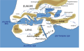
Català: Mapa del món segons Heròdot, segle V a. C. Deutsch: Mögliche Weltdarstellung nach den Historien des Herodot (5. Jahrhundert v. Chr) English: Possibly what the world according to Herodotus looked like (5th century BC). Español: Mapa del mundo según Heródoto, siglo V a. C. Euskara: Munduaren balizko mapa Herodotoren arabera, K. a. V. mendean Français : Reconstruction du monde décrit par Hérodote dans son Enquête (Ve siècle av. J.-C.). Hrvatski: Rekonstruirana karta svijeta prema Herodotu (5. st. pr. Kr.) Italiano: Carta Geografica da Herodotus Ελληνικά: Χάρτης της Οικουμένης κατά τον Ηρόδοτο, τον 5 αιώνα π. Χ. ქართული: ჰეროდოტეს მსოფლიოს რუკა ქართულად ) ไทย: แผนที่โลกที่ใกล้เคียงตามคำกล่าวของเฮอรอโดทัสมากที่สุด (ศตวรรษที่ 5 ก่อนคริสตกาล) 中文: 希罗多德笔下的世界,译名主要依照《历史》(徐松岩译) 注:唯极南的Macrobian人未能在英文维基百科中提到的3.114的英汉译本对应位置找到,只提到了埃塞俄比亚地区的人是人类中身材最为高大的,且条目中提及的防腐技术、寿命等描述也在书中对应埃塞俄比亚人。 العربية : خارطة العالم كما يُحتمل أن تصوره هيرودوت خلال القرن الخامس ق.م.. کوردی: نەخشەی جیھان بەو شێوەیەی کە ھیرۆدیۆت پێشبینی کردووە لە ( قەرنی پێنج پێش میلاد |
|||
| Data | ||||
| Fonte | Own work (based on the GIF by Marco Prins and Jona Lendering from www.livius.org, from http://www.mediterranees.net/geographie/herodote/cartes.html, http://www.henry-davis.com/MAPS/Ancientimages/109A.GIF). Compare this map from The Challenger Reports, 1895. | |||
| Creatore | ||||
| Licenza (Riusare questo file) |
|
|||
| Georeferencing | Georeference the map in Wikimaps Warper If inappropriate please set warp_status = skip to hide. | |||
| Altre versioni |
Opere derivate da questo file: [modifica]
|


Questo file SVG contiene del testo che può essere facilmente tradotto nella tua lingua, utilizzando un editor che supporta SVG (ad esempio un editor XML o di testo). Per maggiori informazioni vedi: Tradurre un file SVG. |
Didascalie
15 dic 2006
image/svg+xml
Cronologia del file
Fare clic su un gruppo data/ora per vedere il file come si presentava nel momento indicato.
| Data/Ora | Miniatura | Dimensioni | Utente | Commento | |
|---|---|---|---|---|---|
| attuale | 03:59, 8 feb 2024 | | 788 × 476 (319 KB) | Manlleus | File uploaded using svgtranslate tool (https://svgtranslate.toolforge.org/). Added translation for ca. |
| 20:32, 3 gen 2023 |  | 788 × 476 (325 KB) | Chiswick Chap | scale a couple of key labels | |
| 12:37, 4 apr 2022 |  | 788 × 476 (315 KB) | Shapez | Reverted to version as of 08:42, 4 February 2022 (UTC) | |
| 19:23, 3 apr 2022 |  | 788 × 476 (341 KB) | Shapez | File uploaded using svgtranslate tool (https://svgtranslate.toolforge.org/). Added translation for ja. | |
| 10:42, 4 feb 2022 |  | 788 × 476 (315 KB) | Andrei Stroe | File uploaded using svgtranslate tool (https://svgtranslate.toolforge.org/). Added translation for ro. | |
| 19:45, 16 mag 2018 |  | 788 × 476 (277 KB) | AnonMoos | Changed "Niniveh" to more usual spellling "Nineveh" | |
| 11:54, 15 nov 2010 |  | 788 × 476 (277 KB) | Bibi Saint-Pol | Reverted to version as of 04:19, 15 December 2006: this is Russian, not English | |
| 00:23, 15 nov 2010 |  | 788 × 476 (277 KB) | McSery | {{Information |Description= {{en|Possibly what the world according to Herodotus looked like (5th century BC).}} |Source=Own work (based on the GIF by Marco Prins and Jona Lendering from www.livius.org, see http://www.livius.org/a/1/maps/ | |
| 06:19, 15 dic 2006 |  | 788 × 476 (277 KB) | Bibi Saint-Pol | doublon Memphis | |
| 04:18, 15 dic 2006 |  | 788 × 476 (277 KB) | Bibi Saint-Pol | {{Inkscape}} {{Information |Description= {{en|Possibly what the map of the world by Herodotus looked like (5th century BC).}} |Source=Own work (based on the GIF by Marco Prins and Jona Lendering from www.livius.org, see http://www.livius |
Pagine che usano questo file
Le seguenti 5 pagine usano questo file:
Utilizzo globale del file
Anche i seguenti wiki usano questo file:
- Usato nelle seguenti pagine di af.wikipedia.org:
- Usato nelle seguenti pagine di azb.wikipedia.org:
- Usato nelle seguenti pagine di bg.wikipedia.org:
- Usato nelle seguenti pagine di bn.wikipedia.org:
- Usato nelle seguenti pagine di ca.wikipedia.org:
- Usato nelle seguenti pagine di cdo.wikipedia.org:
- Usato nelle seguenti pagine di ceb.wikipedia.org:
- Usato nelle seguenti pagine di ckb.wikipedia.org:
- Usato nelle seguenti pagine di cs.wikipedia.org:
- Usato nelle seguenti pagine di en.wikipedia.org:
- Andromeda (mythology)
- Atlantis
- Celts
- Nile
- Generations of Noah
- Dacians
- Libya of Egypt
- Histories (Herodotus)
- Names for India
- Ecumene
- Scylax of Caryanda
- Issedones
- Ancient Libya
- Aethiopia
- List of Graeco-Roman geographers
- Dzungarian Gate
- Macrobians
- User talk:User0512
- User talk:User0510
- Achaemenid conquest of the Indus Valley
- India (Herodotus)
- List of ancient great powers
- Black people in ancient Roman history
- Talk:Eurasia/Archive 1
- Tovsta Mohyla
- Ancient Africa
- User:Falcaorib/Ancient Empires (550-300 BC)
- Usato nelle seguenti pagine di en.wikiquote.org:
- Usato nelle seguenti pagine di en.wikiversity.org:
- Usato nelle seguenti pagine di fa.wikipedia.org:
- Usato nelle seguenti pagine di fi.wikipedia.org:
- Usato nelle seguenti pagine di gl.wikipedia.org:
- Usato nelle seguenti pagine di he.wikipedia.org:
Visualizza l'utilizzo globale di questo file.
Metadati
Questo file contiene informazioni aggiuntive, probabilmente aggiunte dalla fotocamera o dallo scanner usati per crearlo o digitalizzarlo. Se il file è stato modificato, alcuni dettagli potrebbero non corrispondere alla realtà.
| Larghezza | 630.00000pt |
|---|---|
| Altezza | 380.75000pt |