File:East-Hem_475ad.jpg
ウィキペディア フリーな encyclopedia
元のファイル (3,240 × 1,903 ピクセル、ファイルサイズ: 753キロバイト、MIME タイプ: image/jpeg)
ウィキメディア・コモンズのファイルページにある説明を、以下に表示します。
|

|
このhistorical map画像は、ベクターイメージである SVG ファイルとして再作成されるべきです。これにはいくつかの利点があります。詳しくはCommons:Media for cleanupを参照してください。この画像の SVG 形式がすでに利用可能である場合は、アップロードしてください。アップロード後、この画像にあるこのテンプレートを{{Vector version available|新しい画像ファイル名.svg}}テンプレートで置き換えてください。
|
 | この画像(あるいは、このカテゴリーやこのページにある全ての画像)は、JPEG形式でアップロードされました。 しかしながら、PNG形式、あるいはSVG形式で保存すれば、もっと効率的に、もっと正確に情報を含めることができます。もし可能であれば、JPEG圧縮を経ていないデータを元に、または現在のファイルにあるノイズを除去して、この画像を圧縮ノイズのないPNG形式またはSVG形式で再アップロードしてください。 |  |
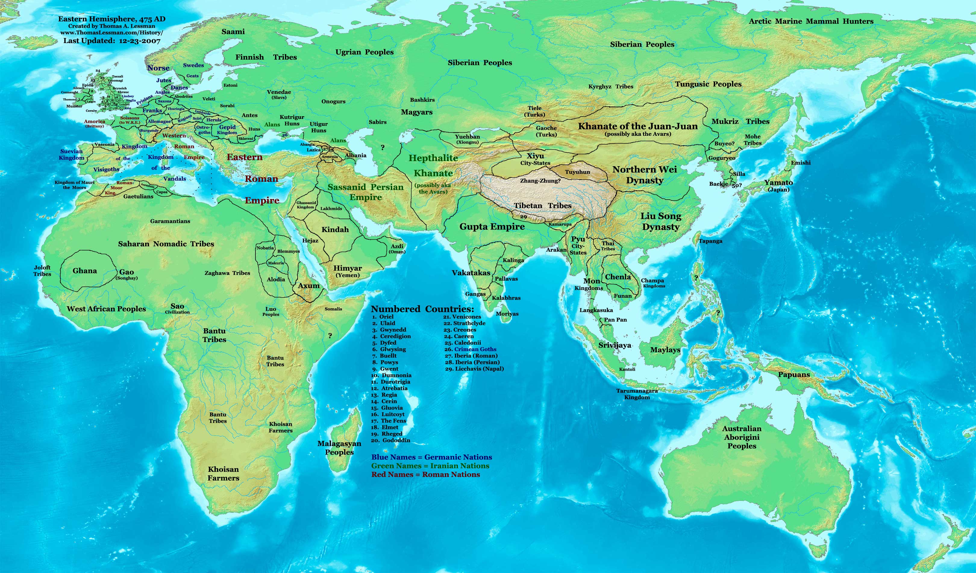
| 解説East-Hem 475ad.jpg | Eastern Hemisphere in 475 AD. |
| 原典 | self-made (For reference information, see the Map Source References section below.) |
| 作者 | Thomas Lessman (Contact!) |
| 許可 (ファイルの再利用) |
この作品の著作権者である私は、この作品を以下のライセンスで提供します。 このファイルはクリエイティブ・コモンズ 表示-継承 3.0 非移植ライセンスのもとに利用を許諾されています。
|
| その他のバージョン |
see the East-Hem 475ad.jpg File History section below.
Map SummaryOriginal Source URL: http://www.thomaslessman.com/History/images/East-Hem_475ad.jpg. This map of the Eastern Hemisphere in 475 AD was created by Thomas Lessman, based on information from the sources listed below. This map is free for educational use (see Permission info above). When using this map, please mention that it is available for free at www.WorldHistoryMaps.info.
Map Source References
References for information contained in this map: 1. Borders of Europe are mostly derived from the Euratlas.com map of Europe in 500 AD. 2. Borders of Britain are derived from the "EarlyBritishKingdoms.com", map of map Britain in 475 AD. 3. Borders of Asian countries derive from various Wikipedia articles and Google history map searches. 4. Some information is derived from Wikimedia's map of The world in 500 CE, created by User:Javierfv1212. 5. Much of the information in this map was cross-checked with Bruce Gordon's Regnal Chronologies. |
Other Historical Maps by Thomas Lessman
| Maps of the eastern hemisphere showing history
Bold dates are available on Wikimedia or Wikipedia. | ||
| Primeval | ||
| Ancient
|
·| 600 BC | 550 BC | 527 BC | 500 BC |
400 BC | ·| 1 AD | 50 AD | 100 AD | 200 AD | 300 AD | | |
| Medieval |
·| 500 AD | 565 AD | 600 AD | 700 AD | | |
| Modern |
·| 1500 AD | · * For historical maps of the whole world, | |
| history links talk edit view | ||
キャプション
このファイルに描写されている項目
題材
ウィキデータ項目がない値
image/jpeg
ファイルの履歴
過去の版のファイルを表示するには、その版の日時をクリックしてください。
| 日付と時刻 | サムネイル | 寸法 | 利用者 | コメント | |
|---|---|---|---|---|---|
| 現在の版 | 2008年2月7日 (木) 15:17 | | 3,240 × 1,903 (753キロバイト) | Rottweiler | {{Information |Description= == Summary == Author: Thomas A. Lessman. Source URL: http://www.ThomasLessman.com/History/images/East-Hem_475ad.jpg. Image was created by Thomas Lessman based on historical information located in sources listed below. This map |
ファイルの使用状況
このファイルを使用しているページはありません。
グローバルなファイル使用状況
以下に挙げる他のウィキがこの画像を使っています:
- ar.wikipedia.org での使用状況
- ce.wikipedia.org での使用状況
- de.wikipedia.org での使用状況
- el.wikipedia.org での使用状況
- en.wikipedia.org での使用状況
- es.wikipedia.org での使用状況
- fr.wikipedia.org での使用状況
- rue.wikipedia.org での使用状況
- ru.wikipedia.org での使用状況
- sh.wikipedia.org での使用状況
- sv.wikipedia.org での使用状況
- ta.wikipedia.org での使用状況
メタデータ
このファイルには、追加情報があります (おそらく、作成やデジタル化する際に使用したデジタルカメラやスキャナーが追加したものです)。
このファイルが元の状態から変更されている場合、修正されたファイルを完全に反映していない項目がある場合があります。
| _error | 0 |
|---|