File:Lexington_Concord_Siege_of_Boston_crop.jpg
ウィキペディア フリーな encyclopedia
元のファイル (2,861 × 2,188 ピクセル、ファイルサイズ: 1.89メガバイト、MIME タイプ: image/jpeg)
ウィキメディア・コモンズのファイルページにある説明を、以下に表示します。
|
概要
| 解説Lexington Concord Siege of Boston crop.jpg |
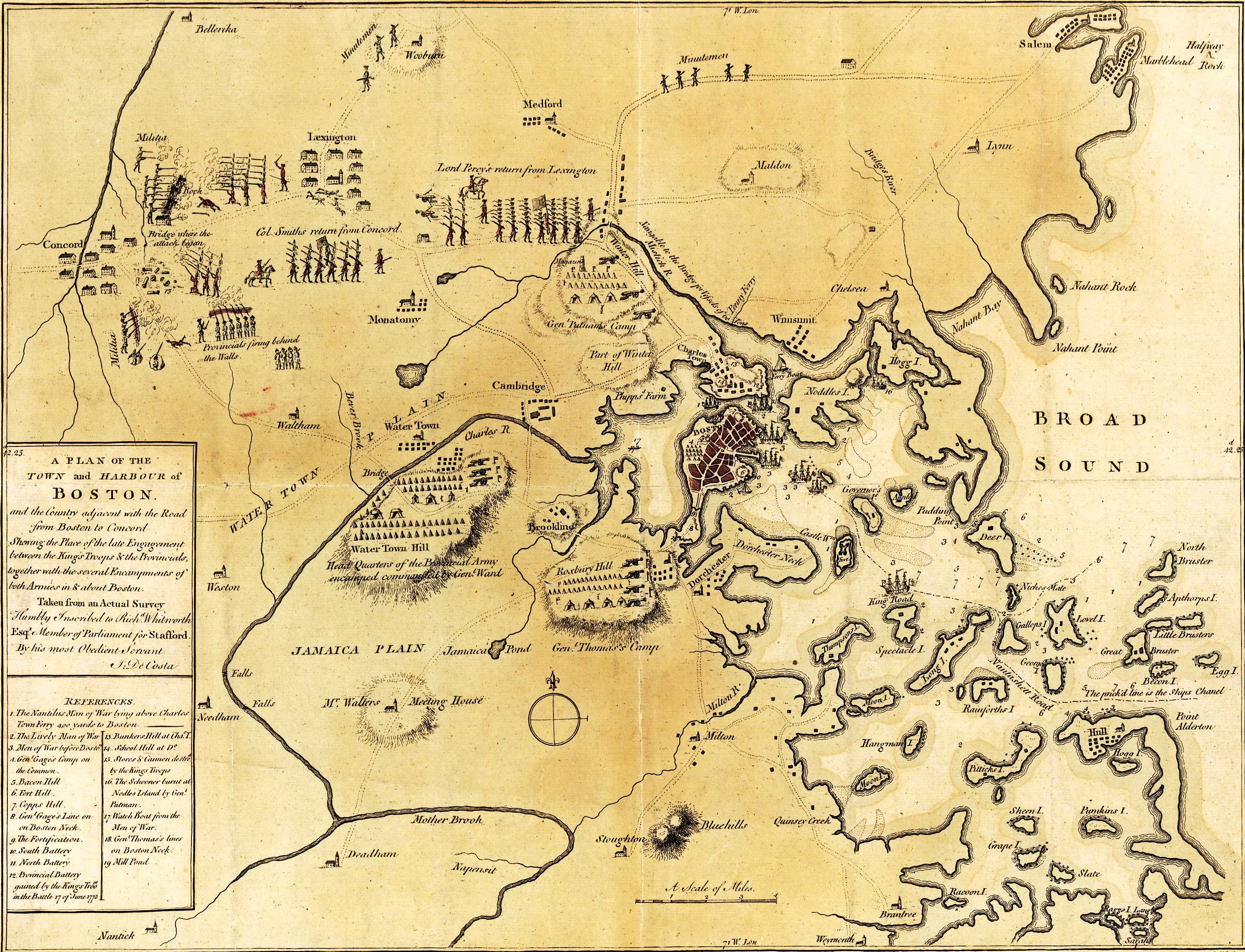
English: A mostly accurate hand-colored map depicting the 1775 Battles of Lexington and Concord and the Siege of Boston |
| 日付 | |
| 原典 |
From the Library of Congress American Memory. |
| 作者 | J. DeCosta |
| その他のバージョン |
 |
Large text box
TOWN and HARBOUR of
Boston.
and the Country adjacent with the Road
from Boston to Concord
Shewing the Place of the late Engagement
between the King's Troops & the Provincials,
together with the several Encampments of
both Armies in & about Boston.
Taken from an Actual Survey
Humbly Inscribed to Rich d. Whitworth
Esqr. Member of Parliament for Stafford
Legend
References.
- The Nautilus Man of War lying above Charles
- Town Ferry 400 yards to Boston
- The Lively Man of War
- Men of War before Boston.
- Gen l. Gage's Camp on
- the Common.
- Bacon Hill [i.e. Beacon Hill]
- Fort Hill.
- Copps Hill.
- Gen l. Gage's Line on
- on Boston Neck.
- The Fortification.
- South Battery
- North Battery
- Provincial Battery
- gained by the King's Troo ps
- in the Battle 17 of June 1775
- Bunkers Hill at Cha s. T.
- School Hill at D o.
- Stores & Cannon destro d
- by the King's Troops
- The Schooner burnt at
- Nodles Island by Gen l.
- Putman
- Watch Boat from the Men of War.
- Gen l. Thomas's lines
- on Boston Neck
- Mill Pond
Text along the bottom
- London Publish'd as the Act directs July 29th. 1775 by J. De Costa Red Croſs Street Southwark.

|
この地図はアメリカ合衆国議会図書館の地理・地図部門から入手できます。デジタル識別子は g3764b.ar090000 です。
このタグは、添付された著作物の著作権状況を示すものではありません。通常の著作権タグも必要です。Commons:ライセンシングもご覧ください。 العربية ∙ беларуская (тарашкевіца) ∙ বাংলা ∙ čeština ∙ Deutsch ∙ English ∙ español ∙ فارسی ∙ suomi ∙ français ∙ galego ∙ עברית ∙ magyar ∙ Bahasa Indonesia ∙ italiano ∙ 日本語 ∙ lietuvių ∙ македонски ∙ മലയാളം ∙ Nederlands ∙ polski ∙ português ∙ português do Brasil ∙ română ∙ русский ∙ sicilianu ∙ slovenčina ∙ slovenščina ∙ Türkçe ∙ українська ∙ 简体中文 ∙ 繁體中文 ∙ +/− |
| Public domainPublic domainfalsefalse |
|
この著作物は、著作権の保護期間が著作者の死後100年以下である国・地域においてパブリックドメインの状態にあります。 | |
| このファイルは著作権法の既知の制約(隣接権や関連する権利を含む)から自由であると特定されています。 | |
https://creativecommons.org/publicdomain/mark/1.0/PDMCreative Commons Public Domain Mark 1.0falsefalse
キャプション
このファイルに描写されている項目
題材
29 7 1775グレゴリオ暦
ファイルの履歴
過去の版のファイルを表示するには、その版の日時をクリックしてください。
| 日付と時刻 | サムネイル | 寸法 | 利用者 | コメント | |
|---|---|---|---|---|---|
| 現在の版 | 2014年7月4日 (金) 03:00 | | 2,861 × 2,188 (1.89メガバイト) | Beyond My Ken | == {{int:filedesc}} == {{Information |author=J. DeCosta |date=1775-07-29 |description={{en|A mostly accurate hand-colored map depicting the 1775 Battles of Lexington and Concord and the [[w:Siege of Boston|Siege o... |
ファイルの使用状況
このファイルを使用しているページはありません。
グローバルなファイル使用状況
以下に挙げる他のウィキがこの画像を使っています:
- azb.wikipedia.org での使用状況
- cs.wikipedia.org での使用状況
- en.wikipedia.org での使用状況
- it.wikipedia.org での使用状況
- ru.wikipedia.org での使用状況
メタデータ
このファイルには、追加情報があります (おそらく、作成やデジタル化する際に使用したデジタルカメラやスキャナーが追加したものです)。
このファイルが元の状態から変更されている場合、修正されたファイルを完全に反映していない項目がある場合があります。
| 原画像データの生成日時 | 2005年5月10日 (火) 02:28 |
|---|---|
| 画像方向 | 通常 |
| 使用ソフトウェア名 | Adobe Photoshop CS Macintosh |
| ファイル変更日時 | 2005年5月10日 (火) 02:28 |
| デジタルデータの作成日時 | 2005年5月10日 (火) 02:28 |
| 原画像データの生成日時(1秒未満) | 00 |
| デジタルデータの作成日時(1秒未満) | 00 |
| 色空間情報 | その他 |