ファイル:IND_timeline.png
ウィキペディア フリーな encyclopedia
元のファイル (2,447 × 3,606 ピクセル、ファイルサイズ: 203キロバイト、MIME タイプ: image/png)
ウィキメディア・コモンズのファイルページにある説明を、以下に表示します。
|

|
このtransport map画像は、ベクターイメージである SVG ファイルとして再作成されるべきです。これにはいくつかの利点があります。詳しくはCommons:Media for cleanupを参照してください。この画像の SVG 形式がすでに利用可能である場合は、アップロードしてください。アップロード後、この画像にあるこのテンプレートを{{Vector version available|新しい画像ファイル名.svg}}テンプレートで置き換えてください。
|
| Public domainPublic domainfalsefalse |
| この著作物は、著作者であるSPUIによって権利が放棄され、パブリックドメインとされました。これは全世界で適用されます。 一部の国では、これが法的に可能ではない場合があります。その場合は、次のように宣言します。 |
License justification:
Questions have arisen about the copyright status of this or related maps, and in fact some of these maps have been deleted. See Commons:Undeletion_requests/Current requests#Image:NYC subway simplified map 50pct-optimized.png for discussion of this matter (diff link). Some of what follows is adapted from that discussion.
Some maps certainly are copyrighted, and some maps such as the two given above certainly are copyrighted by the MTA. Nonetheless, this map, is not copyright by the MTA under the following analysis.
- Any map that is a representation of features of the earth, drawn from knowledge of those features, and not directly a copy of another map, is not a copyright violation of any other particular map merely because it represents the same features. (for if it was it would be impossible to produce any map whatever that was free of hindrance).
- Therefore, it is possible to draw a map of the New York Subway system lines free of hindrance, which are after all features of the earth.
- Maps have markings. A map without markings is not as useful as one with. The letters and numbers used to designate the lines are a kind of knowledge of the features of the earth, just as the name of a town, or the reporting marks of a railway line, or a highway number are a kind of knowledge of the features of the earth (even if the railway reporting marks are a trademark of the railway company, they are nevertheless used on maps as identification). The markings of a map are not themselves copyrightable, only the arrangements of the markings (or the choice to include or not include specific markings) that make a particular version that version. So it is possible to correctly label such a subway map with the correct line designations, as long as in so doing one does not substantially duplicate the marking arrangement (as well as the precise choice of which markings to include or not include) on copyrighted maps.
- So then it is not impossible to create an accurate map of the subway system that is free. What remains is to determine if this map, which is substantially different in appearance than both of the maps that have been cited as evidence of copyright violation, nevertheless violates copyrights of the MTA or predecessors.
- We have ruled out the presence of features, and the markings of those features. What remains is color or symbology.
- Color? Color choice is trade dress, not copyright. Color cannot itself be copyrighted.
- The use of shapes for various line designation symbols? The shapes are squares and circles, not distinctive symbols that could be trademarked. They are very simple geometry, and thus not copyrightable. Only if a particular arrangement of the shapes mimics a copyrighted work, and it is an arrangment that is not logically obvious and necessary, is that arrangement an infringement.
キャプション
このファイルに描写されている項目
題材
ファイルの履歴
過去の版のファイルを表示するには、その版の日時をクリックしてください。
| 日付と時刻 | サムネイル | 寸法 | 利用者 | コメント | |
|---|---|---|---|---|---|
| 現在の版 | 2005年3月15日 (火) 22:14 | | 2,447 × 3,606 (203キロバイト) | SPUI~commonswiki | fixed dates, all but the one with a question mark are confirmed by New York Times articles |
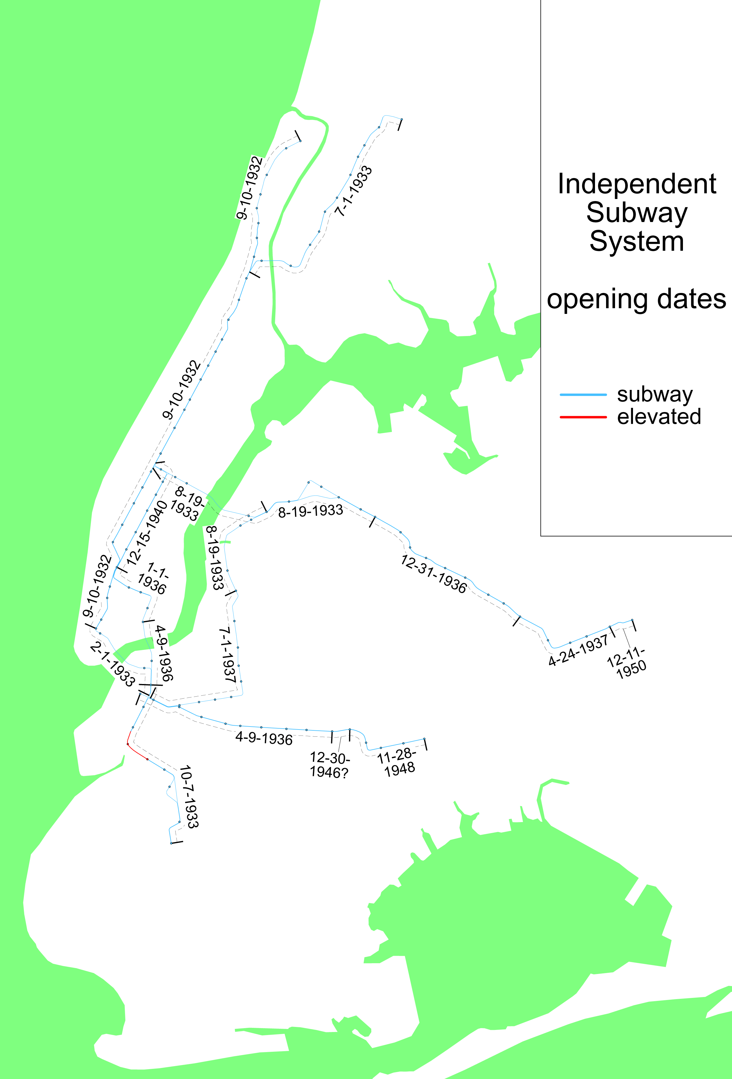
| 2005年2月8日 (火) 22:28 |  | 942 × 1,219 (43キロバイト) | SPUI~commonswiki | {{spuimap}}When each line of the w:Independent Subway System opened. |
ファイルの使用状況
以下のページがこのファイルを使用しています:
グローバルなファイル使用状況
以下に挙げる他のウィキがこの画像を使っています:
- en.wikipedia.org での使用状況
- es.wikipedia.org での使用状況
- nl.wikipedia.org での使用状況
- www.wikidata.org での使用状況
- zh.wikipedia.org での使用状況