파일:East_and_West_Florida_1810.jpg
From Wikipedia, the free encyclopedia
East_and_West_Florida_1810.jpg (412 × 245 픽셀, 파일 크기: 44 KB, MIME 종류: image/jpeg)
| 설명East and West Florida 1810.jpg |
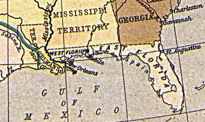
English: Map of East and West Florida in 1810, from the Perry-Castañeda Map Collection [1]. The boundary between the two provinces is incorrect; it was at the Apalachicola River, not the Perdido River (as shown here).
Español: Mapa de Florida Oriental y Florida Occidental en 1810, de la Collección Perry-Castañeda de Mapas[2]. La frontera entre las dos provincias no es correcto; la frontera era el Rio Apalachicola, no el Perdido (como se aparece aquí).
Deutsch: Karte von Ost- und Westflorida 1810. Aus der Kartensammlung der Perry-Castañeda Bibliothek[3]. Die Grenze zwischen Ost- und Westflorida ist unrichtig; die richtige Grenze war der Apalachicola-Fluss anstatt dem Perdido.
Français : Carte de Floride occidentale et de Floride orientale en 1810, provenant de la collection cartographique Perry-Castañeda [4].
La frontière indiquée entre les deux provinces est erronée : elle était formée par le fleuve Apalachicola, et non le fleuve Perdido représenté ici. |
||||||||||||||||||||||
| 날짜 | 1923. Provided on 11 August 2005 by en:User:JW1805 to the English Wikipedia. | ||||||||||||||||||||||
| 출처 | From "The Historical Atlas" by William R. Shepherd, 1923. http://www.lib.utexas.edu/maps/historical/shepherd/us_expansion_shepherd.jpg | ||||||||||||||||||||||
| 저자 |
creator QS:P170,Q8017647 |
||||||||||||||||||||||
| Public domainPublic domainfalsefalse |
|
이 작품은 미국, 그리고 저작권 보호 기간이 저작자 사후 70년, 또는 그 이하인 모든 국가에서 퍼블릭 도메인입니다.
| |
| 이 저작물은 모든 저작인접권을 포함한 저작권법하의 규제로부터 자유로운 것으로 확인되었습니다. | |
https://creativecommons.org/publicdomain/mark/1.0/PDMCreative Commons Public Domain Mark 1.0falsefalse
파일 역사
날짜/시간 링크를 클릭하면 해당 시간의 파일을 볼 수 있습니다.
| 날짜/시간 | 섬네일 | 크기 | 사용자 | 설명 | |
|---|---|---|---|---|---|
| 현재 | 2005년 8월 20일 (토) 22:30 | | 412 × 245 (44 KB) | Sebastian Wallroth | '''en: ''' Map of East and West Florida in 1810. From the Perry-Castañeda Library Map Collection [http://www.lib.utexas.edu/maps/historical/shepherd/us_expansion_shepherd.jpg]. '''de:''' Karte von Ost- und Westflorida 1810. Aus der Kartensammlung der |
이 파일을 사용하는 문서
다음 문서 1개가 이 파일을 사용하고 있습니다:
이 파일을 사용하고 있는 모든 위키의 문서 목록
다음 위키에서 이 파일을 사용하고 있습니다:
- br.wikipedia.org에서 이 파일을 사용하고 있는 문서 목록
- ca.wikipedia.org에서 이 파일을 사용하고 있는 문서 목록
- da.wikipedia.org에서 이 파일을 사용하고 있는 문서 목록
- de.wikipedia.org에서 이 파일을 사용하고 있는 문서 목록
- es.wikipedia.org에서 이 파일을 사용하고 있는 문서 목록
- fr.wikipedia.org에서 이 파일을 사용하고 있는 문서 목록
- gl.wikipedia.org에서 이 파일을 사용하고 있는 문서 목록
- hi.wikipedia.org에서 이 파일을 사용하고 있는 문서 목록
- hu.wikipedia.org에서 이 파일을 사용하고 있는 문서 목록
- id.wikipedia.org에서 이 파일을 사용하고 있는 문서 목록
- it.wikipedia.org에서 이 파일을 사용하고 있는 문서 목록
- ja.wikipedia.org에서 이 파일을 사용하고 있는 문서 목록
- mk.wikipedia.org에서 이 파일을 사용하고 있는 문서 목록
- nn.wikipedia.org에서 이 파일을 사용하고 있는 문서 목록
- no.wikipedia.org에서 이 파일을 사용하고 있는 문서 목록
- pam.wikipedia.org에서 이 파일을 사용하고 있는 문서 목록
- pt.wikipedia.org에서 이 파일을 사용하고 있는 문서 목록
- ro.wikipedia.org에서 이 파일을 사용하고 있는 문서 목록
- ru.wikipedia.org에서 이 파일을 사용하고 있는 문서 목록
- sco.wikipedia.org에서 이 파일을 사용하고 있는 문서 목록
- sv.wikipedia.org에서 이 파일을 사용하고 있는 문서 목록
메타데이터
이 파일에는 카메라나 스캐너가 파일을 만들거나 디지털화하는 데 사용하기 위해 기록한 부가 정보가 포함되어 있습니다.
프로그램에서 파일을 편집한 경우, 새로 저장한 파일에 일부 부가 정보가 빠질 수 있습니다.
| _error | 0 |
|---|