Archivi:Schwarzwald_-_Deutsche_Mittelgebirge,_Serie_A-de.png
From Wikipedia, the free encyclopedia
Fail orginal (2 500 × 3 400 picsel, dimension : 12,29 MByte, sort MIME: image/png)
Quell fail chì el ven de Wikimedia Commons e 'l po vesser doprad de alter proget. La descrizzion sora la soa pagina de descrizzion del fail l'è mostrada chì de sota.
Somari
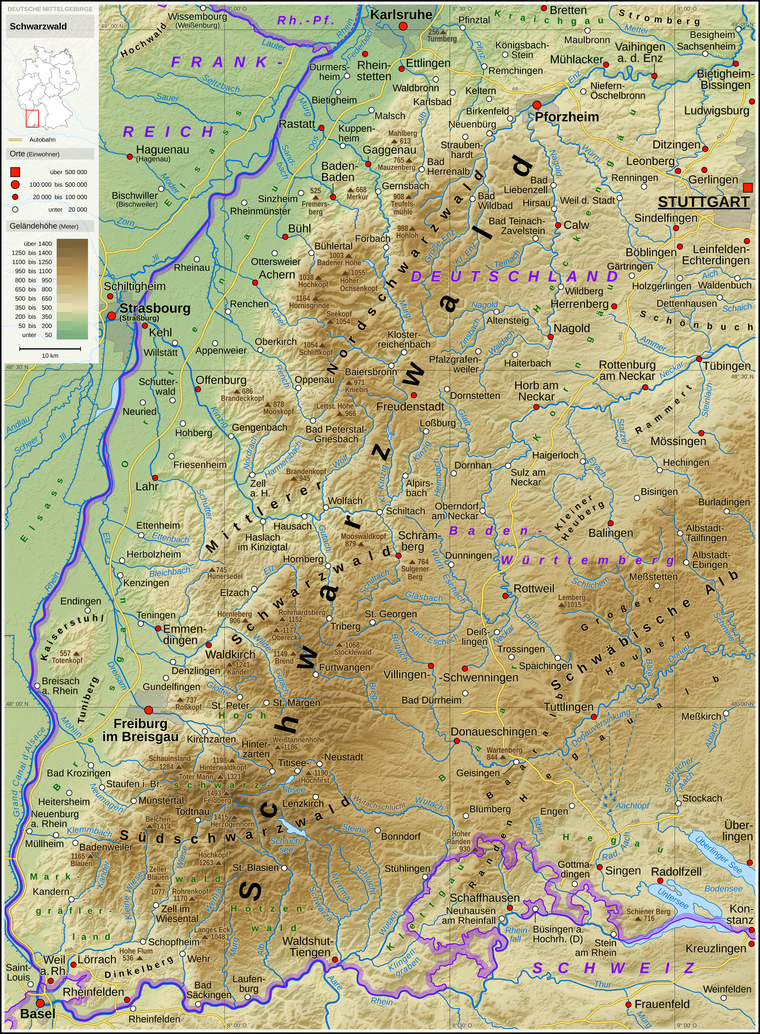
| DescrizzionSchwarzwald - Deutsche Mittelgebirge, Serie A-de.png |
English: Topographic map of the Black Forest
Deutsch: Topografische Karte des Schwarzwaldes |
||||||||||||||||||
| Data | |||||||||||||||||||
| Sorgent |
Opera propria usando: |
||||||||||||||||||
| Autor | Thoroe | ||||||||||||||||||
| Alter version |
 Topographic maps of German low mountain ranges (A series)
This map series aims to show the major low mountain ranges of Germany in a uniform design. All maps are created on the same scale, and the background reliefs base upon the same color scheme. The reliefs are also available as separate files. You can find the making-of one of the maps in the German language Wikipedia (German only).
|
||||||||||||||||||


_-_Deutsche_Mittelgebirge,_Serie_A-de.png)
_-_Deutsche_Mittelgebirge,_Serie_A-de.png)
_-_Deutsche_Mittelgebirge,_Serie_A-de.png)
_-_Deutsche_Mittelgebirge,_Serie_A-de.png)
_-_Deutsche_Mittelgebirge,_Serie_A-de.png)
_-_Deutsche_Mittelgebirge,_Serie_A-de.png)
_-_Deutsche_Mittelgebirge,_Serie_A-de.png)
_-_Deutsche_Mittelgebirge,_Serie_A-de.png)
_-_Deutsche_Mittelgebirge,_Serie_A-de.png)
_-_Deutsche_Mittelgebirge,_Serie_A-de.png)
_-_Deutsche_Mittelgebirge,_Serie_A-de.png)
_-_Deutsche_Mittelgebirge,_Serie_A-de.png)
_-_Deutsche_Mittelgebirge,_Serie_A-de.png)
_-_Deutsche_Mittelgebirge,_Serie_A-de.png)
_-_Deutsche_Mittelgebirge,_Serie_A-de.png)
_-_Deutsche_Mittelgebirge,_Serie_A-de.png)
_-_Deutsche_Mittelgebirge,_Serie_A-de.png)
_-_Deutsche_Mittelgebirge,_Serie_A-de.png)
_-_Deutsche_Mittelgebirge,_Serie_A-de.png)
_-_Deutsche_Mittelgebirge,_Serie_A-de.png)
_-_Deutsche_Mittelgebirge,_Serie_A-de.png)
_-_Deutsche_Mittelgebirge,_Serie_A-de.png)
_-_Deutsche_Mittelgebirge,_Serie_A-de.png)
_-_Deutsche_Mittelgebirge,_Serie_A-de.png)
_-_Deutsche_Mittelgebirge,_Serie_A-de.png)
_-_Deutsche_Mittelgebirge,_Serie_A-de.png)
_-_Deutsche_Mittelgebirge,_Serie_A-de.png)
_-_Deutsche_Mittelgebirge,_Serie_A-de.png)
_-_Deutsche_Mittelgebirge,_Serie_A-de.png)
_-_Deutsche_Mittelgebirge,_Serie_A-de.png)
_-_Deutsche_Mittelgebirge,_Serie_A-de.png)
_-_Deutsche_Mittelgebirge,_Serie_A-de.png)
| This work contains information from OpenStreetMap, which is made available under the Open Database License (ODbL).
The ODbL does not require any particular license for maps produced from ODbL data. Prior to 1 August 2020, map tiles produced by the OpenStreetMap Foundation were licensed under the CC-BY-SA-2.0 license. Maps produced by other people may be subject to other licences.Open Database LicenseODbLhttp://opendatacommons.org/licenses/odbl/1.0/true |

|
Questa mappa è stata prodotta e/o migliorata nel Kartenwerkstatt, il laboratorio grafico della Wikipedia tedesca, dove è possible proporre mappe da migliorare.
azərbaycanca ∙ čeština ∙ Deutsch ∙ Deutsch (Sie-Form) ∙ English ∙ español ∙ français ∙ italiano ∙ latviešu ∙ magyar ∙ Nederlands ∙ Plattdüütsch ∙ polski ∙ português ∙ română ∙ sicilianu ∙ slovenščina ∙ suomi ∙ македонски ∙ русский ∙ ქართული ∙ հայերեն ∙ বাংলা ∙ ไทย ∙ +/−
|
Licenza
- Te see liber:
- de spartì con di alter persone – de copià, mandà in gir e trasmeter el lavorà
- de organizzà de noeuv – de adatà el lavorà
- Sota 'sti condizzion chì:
- atribuzzion –
Te gh'hee de fornì i sgiust credit, un conligament a la licenza e insegnà semai che ghe sien stad portad di cambiament. Te podet fall in una quaisevoeur manera rasgionevol, ma minga d'ona manera che la sugerissa che l'autor approva ti o la toa utilizazzion.
- spartiss con di alter persone a l'istessa manera. – Se ti te mett insema messedand, te transformet, o te scrivet sgiò el material, te gh'hee de mandà in gir i tò contribuzzion sota la same or compatible licens come l'original.
| Annotations InfoField | This image is annotated: View the annotations at Commons |
Schwäbische Alb

Insegna
Element rapresentad in quell fail chì
representa
stato del copyright italian
protezesto da deriti d'autor veneto
19 sgiu 2016
tipo de mèdia d'Internet veneto
image/png
Cronologia de l'archivi
Schiscia in su un grup data/ora per vedè l'archivi com 'a l'è che l'era in quell moment là
| Data/Ora | Miniadura | Grandezza | Utent | Coment | |
|---|---|---|---|---|---|
| corent | 22:15, 13 Mrz 2022 | | 2 500 × 3 400 (12,29 MByte) | Thoroe | Taiflingen -> Tailfingen |
| 15:08, 21 gen 2019 |  | 2 500 × 3 400 (13,33 MByte) | Thoroe | Einwohnerzahl Mössingen | |
| 17:14, 11 oto 2017 |  | 2 500 × 3 400 (12,66 MByte) | Thoroe | einige Flussnamen, Darstellung A98 | |
| 17:38, 17 avr 2017 |  | 2 500 × 3 400 (12,64 MByte) | Thoroe | Some additions | |
| 13:14, 13 avr 2017 |  | 2 500 × 3 400 (12,61 MByte) | Thoroe | Details (Angleichung an Karte der Schwäbischen Alb) | |
| 13:44, 30 sgiu 2016 |  | 2 500 × 3 400 (12,6 MByte) | Thoroe | +Tuniberg, +Staufen, +Büsingen, +Langes Eck | |
| 18:59, 22 sgiu 2016 |  | 2 500 × 3 400 (12,59 MByte) | Thoroe | Kleinigkeiten | |
| 02:28, 22 sgiu 2016 |  | 2 500 × 3 400 (12,57 MByte) | Thoroe | umfassende Überarbeitung | |
| 04:13, 19 sgiu 2016 |  | 2 500 × 3 300 (12,14 MByte) | Thoroe | {{Information |Description ={{en|1=Topographic map of the Black Forest}} {{de|1=Topografische Karte des Schwarzwaldes}} |Source ={{Own using}} *[http://gmt.soest.hawaii.edu Generic Mapping Tools (GMT)... |
Ligámm
Quell fail chì l'è doprad de la pagina chichinscì:
Utilizazzion global di fail
Anca questi Wiki chì a dopren quell fail chì:
- Doperad in als.wikipedia.org
- Doperad in de.wikipedia.org
- Doperad in de.wikivoyage.org
- Doperad in de.wiktionary.org
- Doperad in en.wikipedia.org
- Doperad in en.wiktionary.org
- Doperad in es.wikipedia.org
- Doperad in fi.wikipedia.org
- Doperad in fr.wikipedia.org
- Doperad in gl.wikipedia.org
- Doperad in he.wikipedia.org
- Doperad in hu.wikipedia.org
- Doperad in is.wikipedia.org
- Doperad in it.wikipedia.org
- Doperad in ja.wikipedia.org
- Doperad in nl.wikipedia.org
- Doperad in nn.wikipedia.org
- Doperad in no.wikipedia.org
- Doperad in pl.wikipedia.org
- Doperad in pl.wiktionary.org
- Doperad in simple.wikipedia.org
- Doperad in sk.wikipedia.org
- Doperad in sl.wikipedia.org
- Doperad in sv.wikipedia.org
- Doperad in sw.wikipedia.org
- Doperad in tr.wiktionary.org
- Doperad in vi.wikipedia.org
- Doperad in www.wikidata.org