Attēls:2022_Russian_invasion_of_Ukraine.svg
From Wikipedia, the free encyclopedia

Sākotnējais fails (SVG fails, definētais izmērs 2 199 × 1 478 pikseļi, faila izmērs: 3,73 MB)
| Šis fails ir no Vikikrātuves. Tā apraksts no attēla lapas Vikikrātuvē ir parādīts zemāk. Vikikrātuve ir brīvi licencēta failu krātuve. Tu vari tai palīdzēt. |
Rules for editing the map
|
| All edit warring, adding of unsourced information or performing a color change without consensus may result in the user being blocked. All contributions should first be discussed on the talk page. |
Kopsavilkums

|
This file may be updated to reflect new information. If you wish to use a specific version of the file without new updates being mirrored, please upload the required version as a separate file. |
| Apraksts2022 Russian invasion of Ukraine.svg |
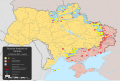
English: Krievijas 2022. gada iebrukums Ukrainā – bruņots konflikts, kas sākās 2022. gada 24. februārī, kad Krievijas bruņotie spēki iegāja Ukrainā [labot šo lapu] |
||||
| Datums | 2022. gada 24. februāris (first version) | ||||
| Avots |
Own work based on: Russo-Ukrainian conflict (2014-2022).svg by Rr016 & Ukraine adm location map improved.svg by Yakiv Gluck
|
||||
| Autors | Viewsridge | ||||
| Citas versijas |
|
||||
| SVG veidošana InfoField | This map is translated using SVG switch elements: all translations are stored in the same file.
|


.gif)

.gif)


_en.png)
_vi.png)
_ru.png)
.svg)
This file is translated using SVG <switch> elements. All translations are stored in the same file! Learn more.
For most Wikipedia projects, you can embed the file normally (without a To translate the text into your language, you can use the SVG Translate tool. Alternatively, you can download the file to your computer, add your translations using whatever software you're familiar with, and re-upload it with the same name. You will find help in Graphics Lab if you're not sure how to do this. |
Licence
- Jūs varat brīvi:
- koplietot – kopēt, izplatīt un pārraidīt darbu
- remiksēt – pielāgot darbu
- Saskaņā ar šādiem nosacījumiem:
- atsaucoties – Tev ir jānorāda autors, saite uz licenci un to, vai veiktas kādas izmaiņas. To var darīt jebkādā saprātīgā veidā, bet ne tādā, kas norādītu, ka licencētājs atbalsta tevi vai veidu, kā tu izmanto šo darbu.
- nemainot licenci – Ja tu miksē, pārveido vai izmanto materiālu, tev savs devums jāpublicē ar to pašu vai saderīgu licenci kā oriģināls.
Captions
Šajā failā attēlotais
attēlo
26 februāris 2022
image/svg+xml
checksum angļu
45b753073ad169247792b2d65d0ff8708bd8afeb
data size angļu
2 514 177 Baits
1 478 pikselis
2 199 pikselis
Faila hronoloģija
Uzklikšķini uz datums/laiks kolonnā esošās saites, lai apskatītos, kā šis fails izskatījās tad.
| Datums/Laiks | Attēls | Izmēri | Dalībnieks | Komentārs | |
|---|---|---|---|---|---|
| tagadējais | 2024. gada 27. maijs, plkst. 10.11 | | 2 199 × 1 478 (3,73 MB) | Physeters | clean up; for future reference, only the red shaded areas on the ISW map are shown as Russian controlled on this map |
| 2024. gada 26. maijs, plkst. 12.14 |  | 2 199 × 1 478 (3,72 MB) | Hoben7599 | Per ISW | |
| 2024. gada 22. maijs, plkst. 14.16 |  | 2 199 × 1 478 (3,32 MB) | Hoben7599 | File uploaded using svgtranslate tool (https://svgtranslate.toolforge.org/). Added translation for zh-hant. | |
| 2024. gada 21. maijs, plkst. 08.49 |  | 2 199 × 1 478 (3,72 MB) | Physeters | Updates per the ISW, update Staromaiorske, Klishshchiivka, and Robotyne per the detailed map | |
| 2024. gada 18. maijs, plkst. 07.00 |  | 2 199 × 1 478 (3,72 MB) | Physeters | Fix Bohudukhiv | |
| 2024. gada 16. maijs, plkst. 23.47 |  | 2 199 × 1 478 (3,72 MB) | Physeters | Updates in Kharkiv Oblast per the ISW | |
| 2024. gada 14. maijs, plkst. 07.40 |  | 2 199 × 1 478 (3,72 MB) | Physeters | fix Derhachi | |
| 2024. gada 13. maijs, plkst. 08.36 |  | 2 199 × 1 478 (3,72 MB) | Alexiscoutinho | Updated Vovchansk per detailed map | |
| 2024. gada 13. maijs, plkst. 05.49 |  | 2 199 × 1 478 (3,72 MB) | Physeters | Updates per the ISW; for future reference, sources (like SuriyakMaps) must first have their reliability vetted on the talk page before they can be used to update the map; at the moment, the only two verified sources are the ISW and the Detailed Map on Wikipedia | |
| 2024. gada 12. maijs, plkst. 13.34 |  | 2 199 × 1 478 (3,31 MB) | BlackShadowG | File uploaded using svgtranslate tool (https://svgtranslate.toolforge.org/). Added translation for zh-tw. |
Faila lietojums
Šo failu izmanto šajās 7 lapās:
Globālais faila lietojums
Šīs Vikipēdijas izmanto šo failu:
- Izmantojums af.wikipedia.org
- Izmantojums als.wikipedia.org
- Izmantojums am.wikipedia.org
- Izmantojums ang.wikipedia.org
- Izmantojums an.wikipedia.org
- Izmantojums ar.wikipedia.org
- Izmantojums ary.wikipedia.org
- Izmantojums arz.wikipedia.org
- Izmantojums ast.wikipedia.org
- Izmantojums azb.wikipedia.org
- Izmantojums az.wikipedia.org
- Izmantojums bar.wikipedia.org
- Izmantojums bat-smg.wikipedia.org
- Izmantojums bcl.wikipedia.org
- Izmantojums be-tarask.wikipedia.org
- Izmantojums be.wikipedia.org
- Izmantojums bg.wikipedia.org
- Izmantojums bh.wikipedia.org
- Izmantojums bn.wikipedia.org
- Izmantojums br.wikipedia.org
- Izmantojums bs.wikipedia.org
- Izmantojums bxr.wikipedia.org
Skatīt šī faila pilno globālo izmantojumu.
Metadati
Šis fails satur papildu informāciju, kuru, visticamāk, ir pievienojis digitālais fotoaparāts vai skeneris, ar ko veidots fails. Ja šis fails pēc tam ir ticis modificēts, šie dati var neatbilst izmaiņām (var būt novecojuši).
| Īsais nosaukums | 2022 Russian invasion of Ukraine |
|---|---|
| Attēla nosaukums | This file uses CSS to set the fill color, stroke color, and stroke width of circles. To change which side controls a city represented by a circle, change the circle's class attribute to "cityru" or "cityuk" or "cityww". This file uses CSS to select the font for place names (class="place") and dates (class="date"). Also map legend headers (class="lhead") and body (class="lhead"). |
| platums | 2199.2 |
| augstums | 1477.6 |