Attēls:Crimean_Khanate_1600.gif
From Wikipedia, the free encyclopedia
Augstāka izšķirtspēja nav pieejama.
Crimean_Khanate_1600.gif (447 × 368 pikseļi, faila izmērs: 23 KB, MIME tips: image/gif)
| Šis fails ir no Vikikrātuves. Tā apraksts no attēla lapas Vikikrātuvē ir parādīts zemāk. Vikikrātuve ir brīvi licencēta failu krātuve. Tu vari tai palīdzēt. |
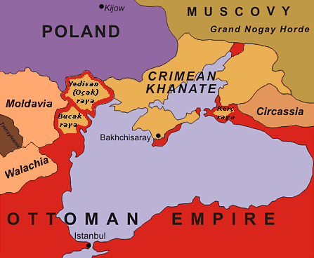
| AprakstsCrimean Khanate 1600.gif | original description: "Black Sea Region in 1600". No reference is given for the data shown in the map. |
| Datums | 13 February 2005 (uploaded to en-wiki as 1600.gif) |
| Avots | NezināmsUnknown source |
| Autors | Oleksa Haiworonski |
| Citas versijas | No labels, Turkish, Norwegian, Russian |

|
This historical map image could be re-created using vector graphics as an SVG file. This has several advantages; see Commons:Media for cleanup for more information. If an SVG form of this image is available, please upload it and afterwards replace this template with
{{vector version available|new image name}}.
It is recommended to name the SVG file “Crimean Khanate 1600.svg”—then the template Vector version available (or Vva) does not need the new image name parameter. |

|
The copyright holder of this work allows anyone to use it for any purpose including unrestricted redistribution, commercial use, and modification.
Usage notes:
Copyrighted free use //commons.wikimedia.org/wiki/File:Crimean_Khanate_1600.gif |
Captions
Pievieno vienas rindiņas aprakstu, ko šis fails attēlo
Šajā failā attēlotais
attēlo
image/gif
checksum angļu
fe1688269a687478a6c26be6e9c4cfb3751413e4
data size angļu
23 722 Baits
368 pikselis
447 pikselis
Faila hronoloģija
Uzklikšķini uz datums/laiks kolonnā esošās saites, lai apskatītos, kā šis fails izskatījās tad.
| Datums/Laiks | Attēls | Izmēri | Dalībnieks | Komentārs | |
|---|---|---|---|---|---|
| tagadējais | 2015. gada 4. jūlijs, plkst. 21.07 | | 447 × 368 (23 KB) | Spiridon Ion Cepleanu | Yedisan, Budzak & Kertch : ottoman territories with tatar autonomous settlements. |
| 2010. gada 20. oktobris, plkst. 18.56 |  | 447 × 368 (26 KB) | Liandrei | Removed watermark and border | |
| 2008. gada 5. maijs, plkst. 16.11 |  | 450 × 371 (27 KB) | Kjetil r | Removing "Ulus of Gazi", I can't find any reference to this nation, it seems like this area was part of the Crimean Khanate | |
| 2006. gada 22. janvāris, plkst. 21.21 |  | 450 × 371 (28 KB) | Hardscarf | Crimean Khanate around 1600 From [http://en.wikipedia.org/wiki/Image:1600.gif english wikipedia] by [http://en.wikipedia.org/wiki/User_talk:Oleksa Oleksa] Original discription: Black Sea Region in 1600 Definition licence: ''Created: Oleksa Haiworon |
Faila lietojums
Šo failu izmanto šajās 2 lapās:
Globālais faila lietojums
Šīs Vikipēdijas izmanto šo failu:
- Izmantojums ar.wikipedia.org
- Izmantojums azb.wikipedia.org
- Izmantojums bn.wikipedia.org
- Izmantojums br.wikipedia.org
- Izmantojums bs.wikipedia.org
- Izmantojums ca.wikipedia.org
- Izmantojums ckb.wikipedia.org
- Izmantojums cs.wikipedia.org
- Izmantojums da.wikipedia.org
- Izmantojums de.wikipedia.org
- Izmantojums el.wikipedia.org
- Izmantojums en.wikipedia.org
- Izmantojums en.wiktionary.org
- Izmantojums eo.wikipedia.org
- Izmantojums es.wikipedia.org
- Izmantojums et.wikipedia.org
- Izmantojums eu.wikipedia.org
- Izmantojums fa.wikipedia.org
- Izmantojums fr.wikipedia.org
- Izmantojums gl.wikipedia.org
- Izmantojums hi.wikipedia.org
- Izmantojums hu.wikipedia.org
Skatīt šī faila pilno globālo izmantojumu.
Saturs iegūts no "https://lv.wikipedia.org/wiki/Attēls:Crimean_Khanate_1600.gif"