Attēls:Yeniseirivermap.png
From Wikipedia, the free encyclopedia
Šī priekšskata izmērs: 601 × 600 pikseļi. Citi izmēri: 240 × 240 pikseļi | 481 × 480 pikseļi | 988 × 986 pikseļi.
Sākotnējais fails (988 × 986 pikseļi, faila izmērs: 325 KB, MIME tips: image/png)
| Šis fails ir no Vikikrātuves. Tā apraksts no attēla lapas Vikikrātuvē ir parādīts zemāk. Vikikrātuve ir brīvi licencēta failu krātuve. Tu vari tai palīdzēt. |

|
This map image could be re-created using vector graphics as an SVG file. This has several advantages; see Commons:Media for cleanup for more information. If an SVG form of this image is available, please upload it and afterwards replace this template with
{{vector version available|new image name}}.
It is recommended to name the SVG file “Yeniseirivermap.svg”—then the template Vector version available (or Vva) does not need the new image name parameter. |
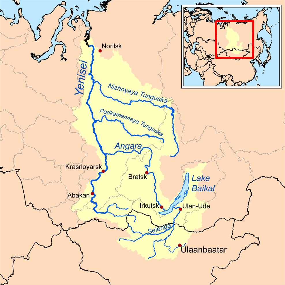
| AprakstsYeniseirivermap.png | This is a map of the Yenisei River drainage basin, with national borders added. |
| Datums | |
| Avots | Own work using Digital Chart of the World and GTOPO data. |
| Autors | Kmusser |
|
|
This map image could be re-created using vector graphics as an SVG file. This has several advantages; see Commons:Media for cleanup for more information. If an SVG form of this image is available, please upload it and afterwards replace this template with
{{vector version available|new image name}}.
It is recommended to name the SVG file “Yeniseirivermap.svg”—then the template Vector version available (or Vva) does not need the new image name parameter. |
Es, šī darba autortiesību īpašnieks, publicēju to saskaņā ar šo licenci:
Šis fails tiek izplatīts saskaņā ar licences Creative Commons Atsauce-Līdzīgi Noteikumi 3.0 Vispārējiem noteikumiem.
- Jūs varat brīvi:
- koplietot – kopēt, izplatīt un pārraidīt darbu
- remiksēt – pielāgot darbu
- Saskaņā ar šādiem nosacījumiem:
- atsaucoties – Tev ir jānorāda autors, saite uz licenci un to, vai veiktas kādas izmaiņas. To var darīt jebkādā saprātīgā veidā, bet ne tādā, kas norādītu, ka licencētājs atbalsta tevi vai veidu, kā tu izmanto šo darbu.
- nemainot licenci – Ja tu miksē, pārveido vai izmanto materiālu, tev savs devums jāpublicē ar to pašu vai saderīgu licenci kā oriģināls.
See also
Captions
Pievieno vienas rindiņas aprakstu, ko šis fails attēlo
Šajā failā attēlotais
attēlo
Šai īpašībai ir vērtība, bet tā ir nezināma
15 septembris 2008
image/png
Faila hronoloģija
Uzklikšķini uz datums/laiks kolonnā esošās saites, lai apskatītos, kā šis fails izskatījās tad.
| Datums/Laiks | Attēls | Izmēri | Dalībnieks | Komentārs | |
|---|---|---|---|---|---|
| tagadējais | 2013. gada 26. oktobris, plkst. 16.32 | | 988 × 986 (325 KB) | Ras67 | cropped, opt. |
| 2008. gada 15. septembris, plkst. 21.10 |  | 1 000 × 1 000 (414 KB) | Kmusser | {{Information |Description=This is a map of the Yenisei River drainage basin. |Source=Own work using http://www.maproom.psu.edu/dcw/ Digital Chart of the World and [[http://edc.usgs.gov/products/elevation/gtopo30/gtopo30.html GTO |
Faila lietojums
Šo failu izmanto šajās 2 lapās:
Globālais faila lietojums
Šīs Vikipēdijas izmanto šo failu:
- Izmantojums af.wikipedia.org
- Izmantojums am.wikipedia.org
- Izmantojums ar.wikipedia.org
- Izmantojums arz.wikipedia.org
- Izmantojums ast.wikipedia.org
- Izmantojums azb.wikipedia.org
- Izmantojums be.wikipedia.org
- Izmantojums bh.wikipedia.org
- Izmantojums bn.wikipedia.org
- Izmantojums bs.wikipedia.org
- Izmantojums ca.wikipedia.org
- Izmantojums cs.wikipedia.org
- Izmantojums cy.wikipedia.org
- Izmantojums da.wikipedia.org
- Izmantojums de.wikipedia.org
- Izmantojums en.wikipedia.org
- Lake Baikal
- Angara
- Yenisey
- Nizhnyaya Tunguska
- New Order (Nazism)
- Soyot
- User:Kmusser/Images
- Tungusic peoples
- Dené–Yeniseian languages
- List of Russian explorers
- Demid Pyanda
- Wikipedia:Graphics Lab/Illustration workshop/Archive/Jan 2011
- Axis powers negotiations on the division of Asia
- Physochlaina
- Yenisei Inscriptions
- Izmantojums eo.wikipedia.org
Skatīt šī faila pilno globālo izmantojumu.
Saturs iegūts no "https://lv.wikipedia.org/wiki/Attēls:Yeniseirivermap.png"