File:1911_EB_Map_Fig_16.png
From Wikipedia, the free encyclopedia
Sākotnējais fails (2 445 × 1 020 pikseļi, faila izmērs: 1,42 MB, MIME tips: image/png)
| Šis fails ir no Vikikrātuves. Tā apraksts no attēla lapas Vikikrātuvē ir parādīts zemāk. Vikikrātuve ir brīvi licencēta failu krātuve. Tu vari tai palīdzēt. |
Kopsavilkums
| Apraksts1911 EB Map Fig 16.png |
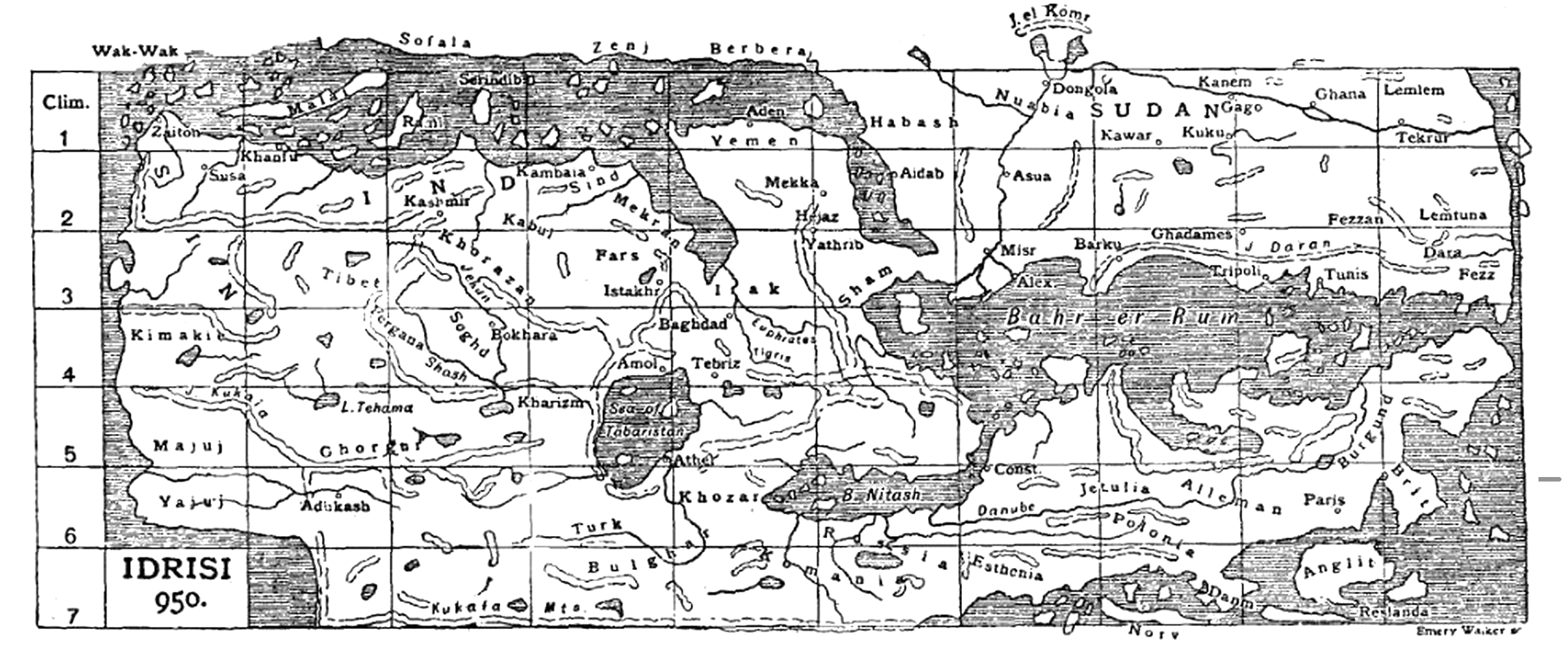
English: Caption: "Fig. 16.—Idrisi (1154)." A simplified black-and-white English, Latin, and Arabic version of the map of the known world composed by al-Idrisi for King Roger II of Sicily. South at top. |
| Datums |
circa 1911. gada date QS:P,+1911-00-00T00:00:00Z/9,P1480,Q5727902 |
| Avots | Map" in the Encyclopaedia Britannica, 11th ed., Vol. XVII, p. 635 ff. |
| Autors | Emery Walker. |
| Atļauja: (Šī faila izmantošana citur) |
PD-US; PD-Britannica |
| Citas versijas |
|


Licence
| Public domainPublic domainfalsefalse |
This media file is in the public domain in the United States. This applies to U.S. works where the copyright has expired, often because its first publication occurred prior to January 1, 1929, and if not then due to lack of notice or renewal. See this page for further explanation.
|
 | |
 |
This image might not be in the public domain outside of the United States; this especially applies in the countries and areas that do not apply the rule of the shorter term for US works, such as Canada, Mainland China (not Hong Kong or Macao), Germany, Mexico, and Switzerland. The creator and year of publication are essential information and must be provided. See Wikipedia:Public domain and Wikipedia:Copyrights for more details.
|
| Public domainPublic domainfalsefalse |
| This image comes from the 13th edition of the Encyclopædia Britannica or earlier. The copyrights for that book have expired in the United States because the book was first published in the US with the publication occurring before January 1, 1929. As such, this image is in the public domain in the United States. |  |
| Annotations InfoField | This image is annotated: View the annotations at Commons |
Clim. or Climata (Climate Zone)
Zaiton
Wak-Wak
Sofala
Zenj
Yemen
Mekka (Mecca)
Hijaz
Berbera
Yathrib (Medina)
Sham (Syria)
Irak (Iraq)
Dongola (Old Dongola)
Misr (Cairo)
Aidab (Adab)
Nuabia (Nubia)
Habash (Abyssinia: Ethiopia)
Norv (Norway)
Yajuj (Gog)
Majuj (Magog)
Tibet
IND (INDIA)
Khanfu
Const. (Constantinople: Istanbul)
Polonia (Poland)
Brit (Britain)
Anglit (England)
Emery Walker sc.
Bulghar (the Volga Bulgars)
Turk (i.e., Kazakhstan)
Khozar (Khazaria)
Athel (Itel)
Sea of Tabaristan (The Caspian Sea)
Alex. (Alexandria)
B. Nitash (The Black Sea)
Esthenia (Estonia)
Rossia (Russia)
Bahr-er-Rum (The Roman Sea: the Mediterranean)
SIN (CHINA)
SUDAN (SAHARAN AFRICA)
Alleman (Germany)
Paris
Burgund (Burgundy)
Kashmir
Asua (Aswan)
Danm (Denmark)
Captions
Šajā failā attēlotais
attēlo
image/png
checksum angļu
43a20a2210224d14b177d24bac826568f9a855b2
data size angļu
1 490 261 Baits
1 020 pikselis
2 445 pikselis
Faila hronoloģija
Uzklikšķini uz datums/laiks kolonnā esošās saites, lai apskatītos, kā šis fails izskatījās tad.
| Datums/Laiks | Attēls | Izmēri | Dalībnieks | Komentārs | |
|---|---|---|---|---|---|
| tagadējais | 2015. gada 4. aprīlis, plkst. 14.58 | | 2 445 × 1 020 (1,42 MB) | LlywelynII | User created page with UploadWizard |
Faila lietojums
Šo failu neizmanto nevienā lapā.
Globālais faila lietojums
Šīs Vikipēdijas izmanto šo failu:
- Izmantojums en.wikisource.org
- Izmantojums fr.wikipedia.org