File:Italy_1494_AD.png
From Wikipedia, the free encyclopedia

Šī priekšskata izmērs: 419 × 600 pikseļi. Citi izmēri: 168 × 240 pikseļi | 335 × 480 pikseļi | 536 × 768 pikseļi | 1 261 × 1 805 pikseļi.
Sākotnējais fails (1 261 × 1 805 pikseļi, faila izmērs: 144 KB, MIME tips: image/png)
| Šis fails ir no Vikikrātuves. Tā apraksts no attēla lapas Vikikrātuvē ir parādīts zemāk. Vikikrātuve ir brīvi licencēta failu krātuve. Tu vari tai palīdzēt. |
The factual accuracy of this map or the file name is disputed.
Reason: Do not use this map until SVG is corrected and PNG updated, as it is mostly based on the Shepherd's map which shows innacurate history of Venetian Republic on Eastern Adriatic, specifically of Dalmatia. It is showing seriouly erroneous and misleading Venetian control over whole region of modern Dalmatia - which became in full extent only in the late 17th and 18th century. It was never the case in the 15th and 16th century, as then most part of Dalmatian hinterland was under Hungarian-Croatian Kingdom and then Ottoman Empire. Venetian Dalmatia at the time included only the very coastal part of Dalmatia with very near hinterland of the Dalmatian city-states, the majority of the hinterland was not Venetian at all. The borders of the Ottoman conquest are also significantly erroneous for the time period as in the map look like modern borders of Bosnia and Herzegovina which became the case only many centuries later.
The map omits a lot of Venice, both islands such as Crete, and coastal areas such as Kotor. |  |

|
File:Italy 1494 AD-it.svg is a vector version of this file. It should be used in place of this PNG file when not inferior.
File:Italy 1494 AD.png → File:Italy 1494 AD-it.svg
For more information, see Help:SVG.
|
 |
Satura rādītājs
Kopsavilkums
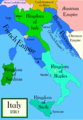
Political map of Italy in early 1494, before the invasion of Italy by Charles VIII of France, created by MapMaster.
Part of a series of maps on the history of Italy:
-
 1000 AD
 -
 1084 AD
 -
 1796 AD
 -
 1810 AD


Versions
PNG:
-
 arābu
arābu -
 angļu
angļu -
 grieķu


SVG:
-
 franču
 -
 itāļu
itāļu -
 ungāru


References
- Bjorklund, Oddvar; Holmboe, Haakon; Rohr, Anders (1970) Historical Atlas of the World, Barnes & Noble, NY, SBN: 389-00253-4.
- Matthew, Donald, (1983), Atlas of Medieval Europe, Checkmark Books, New York.
- Online maps, including this 1882 map from Shepherd (the University of Texas)
- this one from A B Longman, textbook publisher.
Licence
Es, šī darba autortiesību īpašnieks, publicēju to saskaņā ar šīm licencēm:

|
Ir dota atļauja kopēt, izplatīt un/vai pārveidot šo dokumentu saskaņā ar GNU brīvās dokumentācijas licences, versijas 1.2 vai jebkuras vēlākas versijas, ko publiskojis Brīvās programmatūras fonds nosacījumiem; bez nemainīgajām sadaļā, priekšējā un aizmugurēja'vāka tekstiem. Licences kopija ir iekļauta sadaļā ar nosaukumu GNU brīvās dokumentācijas licence.http://www.gnu.org/copyleft/fdl.htmlGFDLGNU Free Documentation Licensetruetrue |
| Šis fails tiek izplatīts saskaņā ar licences Creative Commons Atsauce-Līdzīgi Noteikumi 3.0 Vispārējiem noteikumiem. | ||
| ||
| This licensing tag was added to this file as part of the GFDL licensing update.http://creativecommons.org/licenses/by-sa/3.0/CC BY-SA 3.0Creative Commons Attribution-Share Alike 3.0truetrue |
Jūs varat izvēlēties licenci pēc jūsu vēlmes.
derivative works
Derivative works of this file: Italy 1494 AD-ar.png
Captions
Pievieno vienas rindiņas aprakstu, ko šis fails attēlo
A political map of the Italian Peninsula circa 1494
Faila hronoloģija
Uzklikšķini uz datums/laiks kolonnā esošās saites, lai apskatītos, kā šis fails izskatījās tad.
| Datums/Laiks | Attēls | Izmēri | Dalībnieks | Komentārs | |
|---|---|---|---|---|---|
| tagadējais | 2009. gada 21. aprīlis, plkst. 04.15 | | 1 261 × 1 805 (144 KB) | Capmo | palette reduction to 256 colours |
| 2007. gada 15. aprīlis, plkst. 01.04 |  | 1 261 × 1 805 (539 KB) | MapMaster | Minor modifications | |
| 2007. gada 27. februāris, plkst. 19.07 |  | 1 167 × 1 642 (471 KB) | MapMaster | Modification suggested by User:Paolo da Reggio | |
| 2007. gada 9. janvāris, plkst. 02.52 |  | 1 135 × 1 625 (472 KB) | MapMaster | Political map of Italy in early 1494, before the invasion of Italy by Charles VIII of France, created by MapMaster. |
Faila lietojums
Šo failu neizmanto nevienā lapā.
Globālais faila lietojums
Šīs Vikipēdijas izmanto šo failu:
- Izmantojums af.wikipedia.org
- Izmantojums azb.wikipedia.org
- Izmantojums az.wikipedia.org
- Izmantojums bg.wikipedia.org
- Izmantojums br.wikipedia.org
- Izmantojums bxr.wikipedia.org
- Izmantojums ca.wikipedia.org
- Izmantojums cs.wikipedia.org
- Izmantojums de.wikipedia.org
- Izmantojums el.wikipedia.org
- Izmantojums en.wikipedia.org
- Pope Alexander VI
- Renaissance
- Italian Wars
- Gonzalo Fernández de Córdoba
- Duke of Ferrara and of Modena
- Italian War of 1494–1495
- List of rulers of Montferrat
- User:MapMaster
- Military history of Italy
- User:Juanpdp/Italy
- User:Bolonium/Renaissance
- Marquisate of Incisa
- Timeline of Niccolò Machiavelli
- Italic League
- User:Falcaorib
- Izmantojums eo.wikipedia.org
- Izmantojums es.wikipedia.org
- Izmantojums et.wikipedia.org
Skatīt šī faila pilno globālo izmantojumu.
Metadati
Šis fails satur papildu informāciju, kuru, visticamāk, ir pievienojis digitālais fotoaparāts vai skeneris, ar ko veidots fails. Ja šis fails pēc tam ir ticis modificēts, šie dati var neatbilst izmaiņām (var būt novecojuši).
| Horizontālā izšķirtspēja | 78,74 dpc |
|---|---|
| Vertikālā izšķirtspēja | 78,74 dpc |
Saturs iegūts no "https://lv.wikipedia.org/wiki/Attēls:Italy_1494_AD.png"