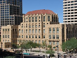
മാരികോപ്പ കൗണ്ടി, അരിസോണ
From Wikipedia, the free encyclopedia
Remove ads
അമേരിക്കൻ ഐക്യനാടുകളിലെ അരിസോണ സംസ്ഥാനത്തിലെ തെക്കൻ കേന്ദ്രത്തിൽ സ്ഥിതി ചെയ്യുന്ന ഒരു രാജ്യമാണ് മാരികോപ്പ കൗണ്ടി (/ˌmærɪˈkoʊpə/ MARR-i-KOH-pə).2010 ലെ സെൻസസ് പ്രകാരം ഇവിടുത്തെ ജനസംഖ്യ 3,817,117 ആണ്.[2] സംസ്ഥാനത്തെ ഏറ്റവും ജനസംഖ്യയുള്ള കൗണ്ടിയും, അമേരിക്കയിലെ നാലാമത്തെ ഏറ്റവും ജനസംഖ്യയുള്ള രാജ്യവുമാണ് ഇത്. 23 സംസ്ഥാനങ്ങളെ അപേക്ഷിച്ച് ഇവിടെ ജനസംഖ്യ വളരെ കൂടുതലാണ്. ഫീനിക്സ് കൗണ്ടി സീറ്റ് സംസ്ഥാന തലസ്ഥാനവും ഐക്യനാടുകളിലെ ഏറ്റവും ജനസംഖ്യയുള്ള അഞ്ചാമത്തെ നഗരവും ആണ്.[3]മാരികോപ്പ കൗണ്ടി സംസ്ഥാന തലസ്ഥാനവും രാജ്യത്തെ അഞ്ചാമത്തെ ഏറ്റവും ജനസംഖ്യയുള്ള നഗരവുമാണ്.
Remove ads
Politics
United States Congress
Board of Supervisors
Elected county officials
†Member was originally appointed to the office.
Remove ads
Education
- Maricopa County Library District operates the county libraries in Maricopa County.
Transportation
Major Highways
Air
The major primary commercial airport of the county is Sky Harbor International Airport (PHX).
Other airports located in the county include:
- Phoenix-Mesa Gateway Airport in Mesa (AZA)
- Scottsdale Municipal Airport in Scottsdale (SCF)
- Deer Valley Airport in Deer Valley Village in Phoenix (DVT)
- Chandler Municipal Airport in Chandler (CHD)
- Phoenix Goodyear Airport in Goodyear (GYR)
- Glendale Municipal Airport in Glendale (GEU)
- Buckeye Municipal Airport in Buckeye (BXK)
- Falcon Field (Arizona) in Mesa (MSC)
- Gila Bend Municipal Airport in Gila Bend (E63)
- Wickenburg Municipal Airport in Wickenburg (E25)
Rail
In terms of freight rail, the Union Pacific Railroad and the Burlington Northern Santa Fe Railroad serve the county.
In terms of passenger rail, greater Phoenix is served by a light rail system. The county has no other passenger rail transport as Amtrak's Sunset Limited, which once served Phoenix until June 2, 1996, has its closest stop in Maricopa in neighboring Pinal County. The train connects Maricopa to Tucson, Los Angeles, and New Orleans three times a week. However it does not stop in Phoenix itself.
Communities
Cities
- Avondale
- Buckeye
- Chandler
- El Mirage
- Glendale
- Goodyear
- Litchfield Park
- Mesa
- Peoria (partly in Yavapai County)
- Phoenix (county seat)
- Scottsdale
- Surprise
- Tempe
- Tolleson
Towns
- Carefree
- Cave Creek
- Fountain Hills
- Gila Bend
- Gilbert
- Guadalupe
- Paradise Valley
- Queen Creek (partly in Pinal County)
- Wickenburg (partly in Yavapai County)
- Youngtown
Census-designated places
- Aguila
- Anthem
- Arlington
- Citrus Park
- Gila Crossing
- Kaka
- Komatke
- Maricopa Colony
- Morristown
- New River
- Rio Verde
- St. Johns
- Sun City
- Sun City West
- Sun Lakes
- Theba
- Tonopah
- Wintersburg
- Wittmann
Unincorporated communities
- Ahwatukee
- Chandler Heights
- Circle City
- Co-op Village
- Desert Hills
- Fort McDowell
- Higley
- Laveen
- Liberty
- Mobile
- Palo Verde
- Rainbow Valley
- Sunflower
- Tortilla Flat
- Waddell
Indian communities
- Fort McDowell Yavapai Nation
- Gila River Indian Community
- Salt River Pima–Maricopa Indian Community
- Tohono O'odham Indian Reservation
County population ranking
The population ranking of the following table is based on the 2010 census of Maricopa County.[8][9]
† county seat
Remove ads
ഇതും കാണുക
- History of Phoenix, Arizona
- Maricopa County Sheriff's Office
- National Register of Historic Places listings in Maricopa County, Arizona
- USS Maricopa County (LST-938)
- White Tank Mountain Regional Park
അവലംബം
കൂടുതൽ വായനയ്ക്ക്
പുറത്തേക്കുള്ള കണ്ണികൾ
Wikiwand - on
Seamless Wikipedia browsing. On steroids.
Remove ads


