Файл:Muscovy_1390_1525.png
From Wikipedia, the free encyclopedia
Үүнээс илүү чанартай хувилбар байхгүй байна.
Muscovy_1390_1525.png (440 × 425 пиксел, файлын хэмжээ: 135 КБ, MIME төрөл: image/png)
Энэ файл нь Wikimedia Commons-нх бөгөөд бусад төслүүд үүнийг хэрэглэх боломжтой. Доор файлын тайлбарын хуудсан дээрх тайлбарыг оруулсан байгаа:
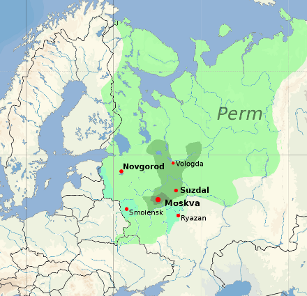
| ТайлбарMuscovy 1390 1525.png |
English: Territorial expansion of the Grand Duchy of Moscow, 1300–1547
|
|||
| Огноо | ||||
| Эх үүсвэр |
blank map: File:Europe location POR.png. Territorial boundaries based on File:Moscow1500.png, File:Kievan-rus-1015-1113-(en).png, File:Muscovy 1300-1462.png. See also File:Russia 1533-1896.gif. See talkpage for discussion of the sources used. Information on historical territory relies on maps uploaded by ru:Участник:Koryakov Yuri (2008). |
|||
| Зохиогч | Dbachmann | |||
| Зөвшөөрөл (Энэ файлыг дахин ашиглах) |
derivative work based on the blank map by David Liuzzo.
|

.png)

|
This historical map image could be re-created using vector graphics as an SVG file. This has several advantages; see Commons:Media for cleanup for more information. If an SVG form of this image is available, please upload it and afterwards replace this template with
{{vector version available|new image name}}.
It is recommended to name the SVG file “Muscovy 1390 1525.svg”—then the template Vector version available (or Vva) does not need the new image name parameter. |
Captions
Add a one-line explanation of what this file represents
Территориальное расширение Великого княжества Московского, 1300–1547 гг. Основная территория Московии, 1300 г.
Items portrayed in this file
depicts англи
copyright status англи
copyrighted англи
copyright license англи
attribution only license англи
media type англи
image/png
Файлын түүх
Огноо/цаг дээр дарж тухайн үеийнх нь файлын байдлыг харна уу.
| Огноо/Цаг | Жижиг зураг | Хэмжээ | Хэрэглэгч | Тайлбар | |
|---|---|---|---|---|---|
| одоогийн | 16:20, 23 Нэгдүгээр сар 2022 | | 440 × 425 (135 КБ) | Ориенталист | Reverted to version as of 16:40, 5 October 2020 (UTC) See File:Russo–Lithuanian Wars-1500 campaign-rus0.2.svg This territories became part of Russia during Ivan III |
| 10:09, 2 Арванхоёрдугаар сар 2021 |  | 440 × 425 (170 КБ) | Dbachmann | Reverted to version as of 13:12, 17 April 2011 (UTC) -- I am sorry, please explain the change, you cannot just say "more accurate" without changing the references to the sources this is based on. | |
| 16:40, 5 Аравдугаар сар 2020 |  | 440 × 425 (135 КБ) | Ориенталист | More accurate | |
| 13:12, 17 Дөрөвдүгээр сар 2011 |  | 440 × 425 (170 КБ) | Dbachmann | update | |
| 12:42, 17 Дөрөвдүгээр сар 2011 |  | 450 × 438 (212 КБ) | Dbachmann | {{Information |Description ={{en|1=Grand Duchy of Moscow (Muscovy) between 1390 and 1547}} |Source =blank map: File:Europe location POR.png |Author =Dbachmann |Date =2011 |Permission = {{Copyrighted free use provided |
Холбоос
Дараахь хуудсууд уг файлтай холбогдсон байна:
Файлын хэрэглээ (бүх төсөл)
Дараах бусад вики энэ файлыг ашигладаг:
- af.wikipedia.org дахь хэрэглээ
- arz.wikipedia.org дахь хэрэглээ
- ast.wikipedia.org дахь хэрэглээ
- ba.wikipedia.org дахь хэрэглээ
- be-tarask.wikipedia.org дахь хэрэглээ
- be.wikipedia.org дахь хэрэглээ
- bn.wikipedia.org дахь хэрэглээ
- bn.wikibooks.org дахь хэрэглээ
- ca.wikipedia.org дахь хэрэглээ
- ce.wikipedia.org дахь хэрэглээ
- cs.wikipedia.org дахь хэрэглээ
- cy.wikipedia.org дахь хэрэглээ
- da.wikipedia.org дахь хэрэглээ
- de.wikipedia.org дахь хэрэглээ
- el.wikipedia.org дахь хэрэглээ
- en.wikipedia.org дахь хэрэглээ
- en.wikibooks.org дахь хэрэглээ
- en.wiktionary.org дахь хэрэглээ
- eo.wikipedia.org дахь хэрэглээ
- es.wikipedia.org дахь хэрэглээ
- et.wikipedia.org дахь хэрэглээ
- eu.wikipedia.org дахь хэрэглээ
Энэ файлын дэлхийн хэрэглээг харах.