चित्र:Balearic_Sea_map.png
From Wikipedia, the free encyclopedia
या झलकेचा आकार: ८०० × ५११ पिक्सेल पिक्सेल. इतर resolutions: ३२० × २०४ पिक्सेल | ६४० × ४०९ पिक्सेल | १,००० × ६३९ पिक्सेल.
मूळ संचिका (१,००० × ६३९ पिक्सेल, संचिकेचा आकार: ७७ कि.बा., MIME प्रकार: image/png)
ही संचिका Wikimedia Commons येथील असून ती इतर प्रकल्पात वापरलेली असू शकते. तिचे तेथील संचिका वर्णन पान खाली दाखवले आहे.
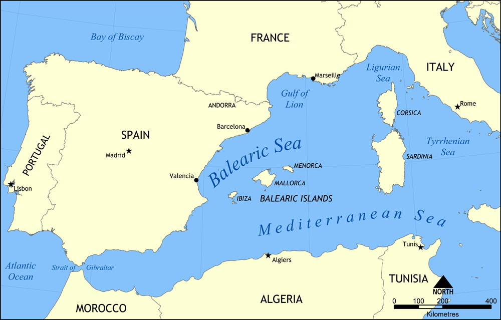
Map showing the location of the Balearic Sea, part of the Mediterranean Sea.
Created by NormanEinstein, May 26, 2006.
I, the copyright holder of this work, hereby publish it under the following license:

|
फ्री सॉफ्टवेअर फाऊंडेशन द्वारे प्रकाशित जीएनयू मुक्त दस्ताऐवजीकरण परवाना, आवृत्ती १.२ किंवा त्यानंतरची,या अंतर्गत; या दस्तावेजास, नकलविण्याची, वितरणाची व/किंवा फेरबदलाची परवानगी दिल्या जाते या अटींसह कि त्यात कोणतेही निश्चलित(Invariant) विभाग नकोत,पृष्टपान मजकूर नको व मलपान मजकूर नको. GNU Free Documentation License हा मथळा असलेल्या विभागात,या परवान्याची प्रत अंतर्भूत केलेली आहे.http://www.gnu.org/copyleft/fdl.htmlGFDLGNU Free Documentation Licensetruetrue |
| ही संचिका खालील परवान्याअंतर्गत आहे - क्रीएटिव्ह कॉमन्स Attribution-Share Alike 3.0 Unported. | ||
| ||
| GFDL चा भाग म्हणून परवाना अपडेट हि परवाना खूण या संचिकेस जोडलेली होती. (संचिका म्हणजे File)http://creativecommons.org/licenses/by-sa/3.0/CC BY-SA 3.0Creative Commons Attribution-Share Alike 3.0truetrue |
Captions
Add a one-line explanation of what this file represents
Map showing Western Mediterranean coastline
Items portrayed in this file
depicts इंग्रजी
copyright status इंग्रजी
copyrighted इंग्रजी
image/png
checksum इंग्रजी
a49ade01600650f2cd98584c735cdf04010e1eec
data size इंग्रजी
७९,३४१ byte
६३९ चित्रपेशी
१,००० चित्रपेशी
संचिकेचा इतिहास
संचिकेची त्यावेळची आवृत्ती बघण्यासाठी त्या दिनांक/वेळेवर टिचकी द्या.
| दिनांक/वेळ | छोटे चित्र | आकार | सदस्य | प्रतिक्रीया | |
|---|---|---|---|---|---|
| सद्य | २१:०१, २६ मे २००६ | | १,००० × ६३९ (७७ कि.बा.) | NormanEinstein | Map showing the location of the Balearic Sea, part of the Mediterranean Sea. Created by NormanEinstein, May 26, 2006. {{GFDL-self}} Category:Maps of seas |
दुवे
खालील पाने या संचिकेला जोडली आहेत:
जागतिक संचिका उपयोग
संचिकाचे इतर विकिपीडियावरील वापरः
- af.wikipedia.org वरील उपयोग
- an.wikipedia.org वरील उपयोग
- avk.wikipedia.org वरील उपयोग
- az.wikipedia.org वरील उपयोग
- az.wiktionary.org वरील उपयोग
- be.wikipedia.org वरील उपयोग
- bg.wikipedia.org वरील उपयोग
- bn.wikipedia.org वरील उपयोग
- bs.wikipedia.org वरील उपयोग
- ca.wikipedia.org वरील उपयोग
- ce.wikipedia.org वरील उपयोग
- ckb.wikipedia.org वरील उपयोग
- cv.wikipedia.org वरील उपयोग
- da.wikipedia.org वरील उपयोग
- en.wikipedia.org वरील उपयोग
- HMS Nelson (28)
- French battleship Bouvet
- Balearic Sea
- Malta convoys
- User:NormanEinstein/gallery
- French ironclad Dévastation
- French battleship Mirabeau
- French battleship Justice
- French battleship Vérité
- French battleship République
- French battleship Patrie
- French ironclad Magenta (1890)
- French battleship Charles Martel
- French battleship Brennus
- French ironclad Marceau
- French ironclad Neptune
- French cruiser Lavoisier
- French cruiser Troude
- Action of 19 February 1801
- User talk:Keith-264/sandbox5
- French cruiser Milan
- French cruiser Tage
- French cruiser Sfax
- French cruiser Forbin
- French cruiser Lalande
- French cruiser Cosmao
- French cruiser Cassard
- French cruiser Du Chayla
- French cruiser D'Iberville
- French cruiser Casabianca
- es.wikipedia.org वरील उपयोग
या संचिकेचे अधिक वैश्विक उपयोग पहा
"https://mr.wikipedia.org/wiki/चित्र:Balearic_Sea_map.png" पासून हुडकले