Bestand:ALMAs_OSF_An_Oasis_in_the_Desert.jpg
Uit Wikipedia, de vrije encyclopedia
Grootte van deze voorvertoning: 800 × 529 pixels. Andere resoluties: 320 × 212 pixels | 640 × 423 pixels | 1.024 × 677 pixels | 1.280 × 846 pixels | 2.560 × 1.692 pixels | 4.538 × 3.000 pixels.
Oorspronkelijk bestand (4.538 × 3.000 pixels, bestandsgrootte: 3,34 MB, MIME-type: image/jpeg)
| Dit is een bestand van Wikimedia Commons. Onderstaande beschrijving komt van de beschrijving van het bestand daar. |
Beschrijving
| BeschrijvingALMAs OSF An Oasis in the Desert.jpg |
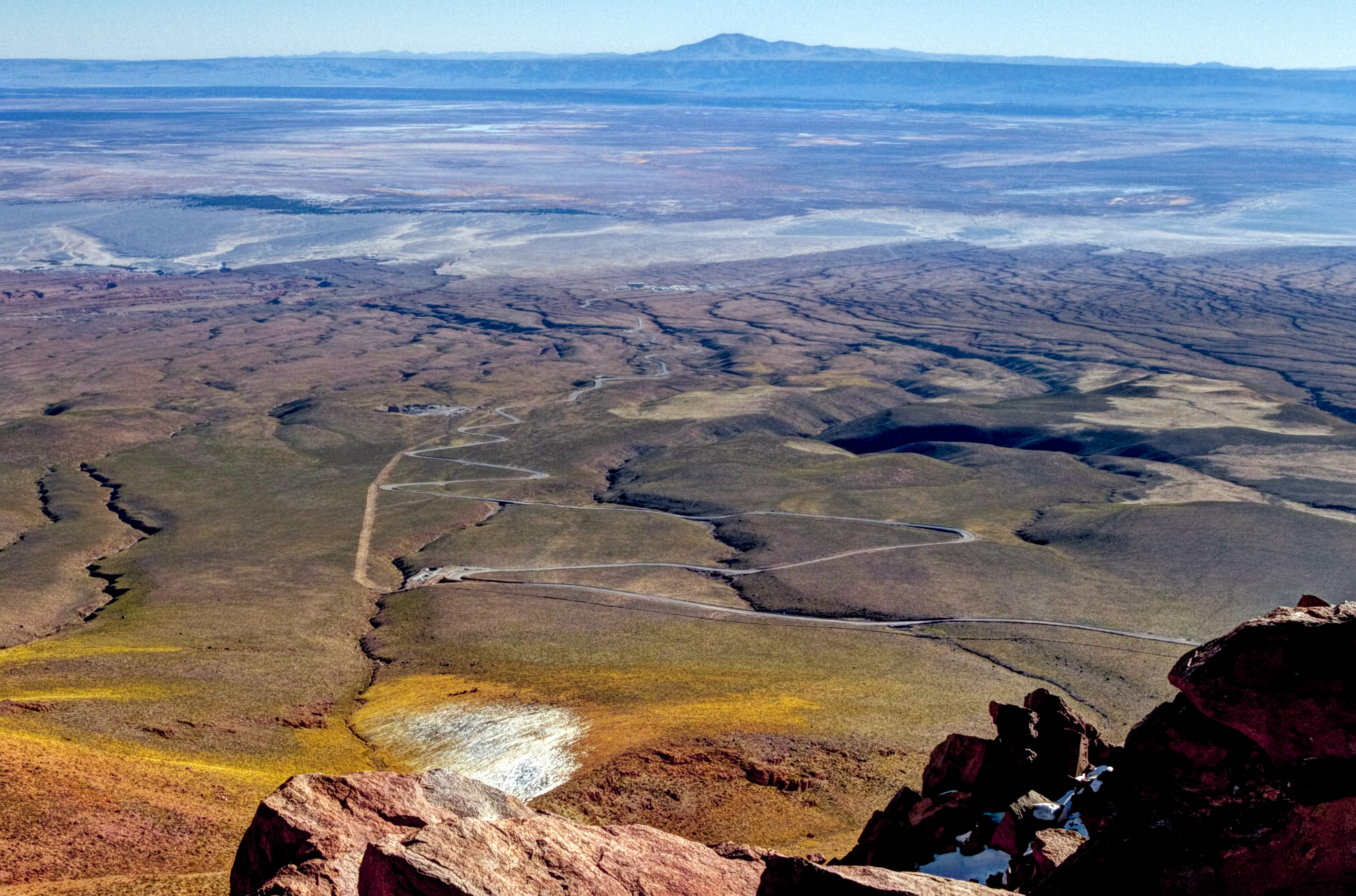
English: At the end of the long, winding road in this image is the Atacama Large Millimeter/submillimeter Array (ALMA)’s Operational Support Facility (OSF). The OSF serves as a base camp for contractors and staff working at ALMA and its facilities are the centre of all scientific activities related to ALMA’s daily operation. Beyond the ALMA camp the white salt flat known as El Salar de Atacama is visible, the largest salt flat in Chile. Towards the horizon is the mountain known as Cerro Quimal. This photograph was taken from 4660 metres above sea level by photographer José Velásquez during a Sunday trek from Cerro de Macón towards the Array Operations Site (AOS). ALMA is the largest astronomical project in existence and is a truly global partnership between Europe, North America and East Asia, in cooperation with the Republic of Chile. Last year, ALMA was inaugurated at an official ceremony, which marked the completion of all the major systems of the array and the formal transition from a construction project to a fully-fledged observatory. Links This photo on Flickr Your ESO Pictures on Flickr José Velásquez’s Flickr stream |
||||
| Datum | |||||
| Bron | http://www.eso.org/public/images/potw1515a/ | ||||
| Auteur | J. Velásquez/ESO | ||||
| Toestemming (Hergebruik van dit bestand) |
|
||||
| Cameralocatie | 23° 04′ ZB, 67° 52′ WL | Deze en andere afbeeldingen in: OpenStreetMap |
|---|
| Aantekeningen InfoField | Deze afbeelding is aangetekend: Bekijk de aantekeningen op Commons |
562
248
134
43
1280
846
.jpg)
598
16
146
51
1280
846

6
233
128
37
1280
846
Zapar
2
101
1277
117
1280
846
Salar de Atacama
2059
890
397
153
4538
3000
Atacama Large Millimeter/submillimeter Array (ALMA)’s Operational Support Facility
2297
74
369
147
4538
3000
Cerro Quimal
17
289
4515
584
4538
3000
El Salar de Atacama
Bijschriften
Beschrijf in één regel wat dit bestand voorstelt
Items getoond in dit bestand
beeldt af
13 apr 2015
23°3'42.998"S, 67°51'56.002"W
image/jpeg
fb14db54ddef5480612dd4229202909253e0e14b
331.879 byte
846 pixel
1.280 pixel
Bestandsgeschiedenis
Klik op een datum/tijd om het bestand te zien zoals het destijds was.
| Datum/tijd | Miniatuur | Afmetingen | Gebruiker | Opmerking | |
|---|---|---|---|---|---|
| huidige versie | 14 feb 2024 12:49 | | 4.538 × 3.000 (3,34 MB) | C messier | full size |
| 14 apr 2015 02:46 |  | 1.280 × 846 (324 kB) | Jmencisom | User created page with UploadWizard |
Bestandsgebruik
Dit bestand wordt op de volgende pagina gebruikt:
Globaal bestandsgebruik
De volgende andere wiki's gebruiken dit bestand:
- Gebruikt op ca.wikipedia.org
- Gebruikt op en.wikipedia.org
- Gebruikt op es.wikipedia.org
Metadata
Dit bestand bevat metadata met EXIF-informatie, die door een fotocamera, scanner of fotobewerkingsprogramma toegevoegd kan zijn.
| Gebruikte software | Adobe Photoshop CC 2014 (Windows) |
|---|---|
| Tijdstip gegevensaanmaak | 13 apr 2015 10:00 |
| Auteursrechtenstatus | Auteursrechtelijke status niet ingesteld |
| Uniek ID van het originele document | 1019406330AEAC2D22AF61AFF5BBCBB3 |
| Credit/Leverancier | J. Velásquez/ESO |
| Bron | European Southern Observatory |
| Gebruiksvoorwaarden |
|
| Contactgegevens |
Karl-Schwarzschild-Strasse 2 Garching bei München, None, D-85748 Germany |
| Korte naam |
|
| Omschrijving afbeelding |
|
| Trefwoorden |
|
| IIM-versie | 4 |