Bestand:BlankMap-World-1970.png
Uit Wikipedia, de vrije encyclopedia
Oorspronkelijk bestand (1.357 × 628 pixels, bestandsgrootte: 48 kB, MIME-type: image/png)
| Dit is een bestand van Wikimedia Commons. Onderstaande beschrijving komt van de beschrijving van het bestand daar. |

|
Deze kaartafbeelding zou opnieuw moeten worden aangemaakt als een SVG-bestand door vectorafbeeldingen te gebruiken. Dit heeft een aantal voordelen; zie Commons:Media for cleanup voor meer informatie. Als er een SVG-formaat van deze afbeelding bestaat, dan deze graag uploaden. Nadat u dit heeft gedaan, gelieve dit sjabloon te vervangen door het sjabloon {{vector version available|nieuwe bestandsnaam.svg}} op deze afbeeldingspagina.
|
Beschrijving
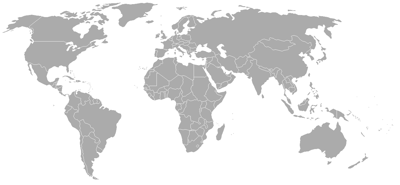
Map of the world with 1970 borders. Differences with 1985 map include: Portuguese Timor separate from Indonesia, Sikkim independent from India, North and South Vietnam separate, Walvis Bay not part of South West Africa.
Should be accurate for the period between January 4, 1969 (Spain hands over Ifni to Morocco), December 18, 1969 (Saudi-Kuwaiti neutral zone partioned between Kuwait and Saudi Arabia), and May 16, 1975 (Sikkim becomes part of India). Further information see: List of national border changes since World War I
| Blank maps of the world for historical use | |
| pre-1800 | |
|
19th century | |
|
20th century | |
|
1902 · 1912 · 1914 · WWI · Aug 1918 · 1920 · 1921 · 1924 · 1926 · 1935 · 1937 · Mar 1938 · Oct 1938 · Mar 1939 · Oct 1939 · WWII · Nov 1942 · May 1945 · 1957 · 1959 · 1962 · 1968 · 1970 · 1985 · 1990 · 1993 | |
|
21st century | |
| (this template: · view · discuss ) | |
.PNG)
Licentie

|
Toestemming wordt verleend voor het kopiëren, verspreiden en/of wijzigen van dit document onder de voorwaarden van de GNU-licentie voor vrije documentatie, versie 1.2 of enige latere versie als gepubliceerd door de Free Software Foundation; zonder Invariant Sections, zonder Front-Cover Texts, en zonder Back-Cover Texts. Een kopie van de licentie is opgenomen in de sectie GNU-licentie voor vrije documentatie.http://www.gnu.org/copyleft/fdl.htmlGFDLGNU Free Documentation Licensetruetrue |
| Dit bestand is gelicenseerd onder de Creative Commons-licentie Naamsvermelding-Gelijk delen 3.0 Unported | ||
| ||
| Deze licentietag is toegevoegd aan dit bestand in verband met de GFDL licentie-update.http://creativecommons.org/licenses/by-sa/3.0/CC BY-SA 3.0Creative Commons Attribution-Share Alike 3.0truetrue |
| Aantekeningen InfoField | Deze afbeelding is aangetekend: Bekijk de aantekeningen op Commons |
Conflict between Argentina - United Kingdom in Falkland Islands / Islas Malvinas.
Bijschriften
Items getoond in dit bestand
beeldt af
image/png
79542df6ee3ef9c534436c48f8cbfe608b37a91a
49.148 byte
628 pixel
1.357 pixel
Bestandsgeschiedenis
Klik op een datum/tijd om het bestand te zien zoals het destijds was.
| Datum/tijd | Miniatuur | Afmetingen | Gebruiker | Opmerking | |
|---|---|---|---|---|---|
| huidige versie | 24 sep 2007 04:50 | | 1.357 × 628 (48 kB) | Hoshie | put the (N/S) Yemen boundary in white due to the fact the boundaries in southern Saudi Arabia have been disputed, undemarcated, or undisclosed over the years. |
| 6 aug 2007 03:22 |  | 1.357 × 628 (48 kB) | Hoshie | added Cabinda, under same lic. as orginal. | |
| 29 jan 2007 04:59 |  | 1.357 × 628 (48 kB) | Hoshie | added the Canal Zone | |
| 28 jan 2007 12:29 |  | 1.357 × 628 (48 kB) | Hoshie | Saudi Arabia-Yemen boundry did not exist during this time. | |
| 5 jan 2007 11:02 |  | 1.357 × 628 (48 kB) | Roke~commonswiki | Blank map of the world in 1970. Differences with 1985 map include: Portugese Timor separate from Indonesia, Sikkim independent from India, North and South Vietnam separate, Walvis Bay not part of South Africa. [[Categor |
Bestandsgebruik
Dit bestand wordt op de volgende 4 pagina's gebruikt:
Globaal bestandsgebruik
De volgende andere wiki's gebruiken dit bestand:
- Gebruikt op ca.wikipedia.org
- Gebruikt op de.wikipedia.org
- Gebruikt op es.wikipedia.org
- Gebruikt op fr.wikipedia.org
- Gebruikt op zh.wikipedia.org