Bestand:Karte_Ennetbirgische_Vogteien.png
Uit Wikipedia, de vrije encyclopedia
Grootte van deze voorvertoning: 593 × 599 pixels. Andere resoluties: 237 × 240 pixels | 475 × 480 pixels | 760 × 768 pixels | 1.013 × 1.024 pixels | 1.500 × 1.516 pixels.
Oorspronkelijk bestand (1.500 × 1.516 pixels, bestandsgrootte: 570 kB, MIME-type: image/png)
| Dit is een bestand van Wikimedia Commons. Onderstaande beschrijving komt van de beschrijving van het bestand daar. |
Beschrijving
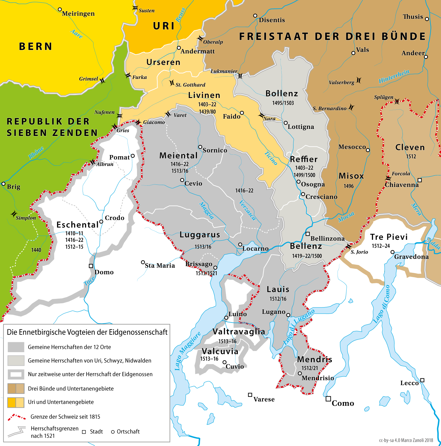
| BeschrijvingKarte Ennetbirgische Vogteien.png | Karte der Ennetbirgischen Vogteien der Eidgenossenschaft bis 1798 |
| Datum | |
| Bron | nach Adolf Gasser / Ernst Keller: Historische Karte zur territorialen Entwicklung der Schweizerischen Eidgenossenschaft 1291–1797, 1932. |
| Auteur | Marco Zanoli (sidonius 09:19, 30 May 2006 (UTC)) |
| Andere versies |
|

Licentie
You may use my work outside wikipedia for free as long as you name me as the author. If you would like to use my work in a print medium, please send me a specimen copy.
Contact me if you have questions regarding the license or if you want individual changes to the map (marco.zanoli at hotmail.ch). Dit bestand is gelicenseerd onder de Creative Commons Naamsvermelding-GelijkDelen 4.0 Internationaal licentie. Naamsvermelding: Marco Zanoli
|
Bijschriften
Beschrijf in één regel wat dit bestand voorstelt
Items getoond in dit bestand
beeldt af
30 mei 2006
Bestandsgeschiedenis
Klik op een datum/tijd om het bestand te zien zoals het destijds was.
| Datum/tijd | Miniatuur | Afmetingen | Gebruiker | Opmerking | |
|---|---|---|---|---|---|
| huidige versie | 16 dec 2018 18:22 | | 1.500 × 1.516 (570 kB) | Sidonius | Revidierte Version, einige Fehler behoben, Ausschnitt verkleinert, |
| 7 jun 2015 23:14 |  | 1.548 × 1.536 (346 kB) | Cmdrjameson | Compressed with pngout. Reduced by 194kB (35% decrease). | |
| 22 okt 2012 22:22 |  | 1.548 × 1.536 (541 kB) | Sidonius | -Fehler in Legende behoben -zusätzliche Pässe eingefügt -Rahmen entfernt -kleinere Anpassungen im Layout und in der Karte | |
| 4 jul 2010 06:51 |  | 1.500 × 1.488 (816 kB) | DcoetzeeBot | Remove watermark, add author and license data to image metadata, decrease filesize with pngcrush | |
| 30 mei 2006 11:19 |  | 1.500 × 1.488 (950 kB) | Sidonius | {{Information| |Description=Karte der Ennetbirgischen Vogteien der Alten Eidgenossenschaft 1403–1798 |Source=nach Adolf Gasser / Ernst Keller: Historische Karte zur territorialen Entwicklung der Schweizerischen Eidgenossenschaft 1291–1797, 1932 |Date= |
Bestandsgebruik
Dit bestand wordt op de volgende 3 pagina's gebruikt:
Globaal bestandsgebruik
De volgende andere wiki's gebruiken dit bestand:
- Gebruikt op als.wikipedia.org
- Gebruikt op bar.wikipedia.org
- Gebruikt op cs.wikipedia.org
- Gebruikt op de.wikipedia.org
- 1403
- Kanton Tessin
- Alte Eidgenossenschaft
- Gemeine Herrschaft
- Schlacht bei Marignano
- Benutzer:Sidonius
- Ennetbergische Vogteien
- Ossolatal
- Geschichte des Kantons Tessin
- Schlacht bei Arbedo
- Ennetbirgische Feldzüge
- Val Travaglia
- Val Cuvia
- Schweizer Truppen in päpstlichen Diensten
- Ewige Richtung mit Frankreich
- Gebruikt op en.wikipedia.org
- Gebruikt op et.wikipedia.org
- Gebruikt op fr.wikipedia.org
- Gebruikt op he.wikivoyage.org
- Gebruikt op hr.wikipedia.org
- Gebruikt op ru.wikipedia.org
Metadata
Dit bestand bevat metadata met EXIF-informatie, die door een fotocamera, scanner of fotobewerkingsprogramma toegevoegd kan zijn.
| Gebruikte software | |
|---|---|
| Auteursrechtenhouder |
|
| Omschrijving afbeelding |
|
Overgenomen van "https://nl.wikipedia.org/wiki/Bestand:Karte_Ennetbirgische_Vogteien.png"