Bestand:Satellite_image_of_Spain_in_January_2003.jpg
Uit Wikipedia, de vrije encyclopedia
Grootte van deze voorvertoning: 714 × 600 pixels. Andere resoluties: 286 × 240 pixels | 571 × 480 pixels | 914 × 768 pixels | 1.219 × 1.024 pixels | 2.437 × 2.048 pixels | 4.175 × 3.508 pixels.
Oorspronkelijk bestand (4.175 × 3.508 pixels, bestandsgrootte: 2,42 MB, MIME-type: image/jpeg)
| Dit is een bestand van Wikimedia Commons. Onderstaande beschrijving komt van de beschrijving van het bestand daar. |
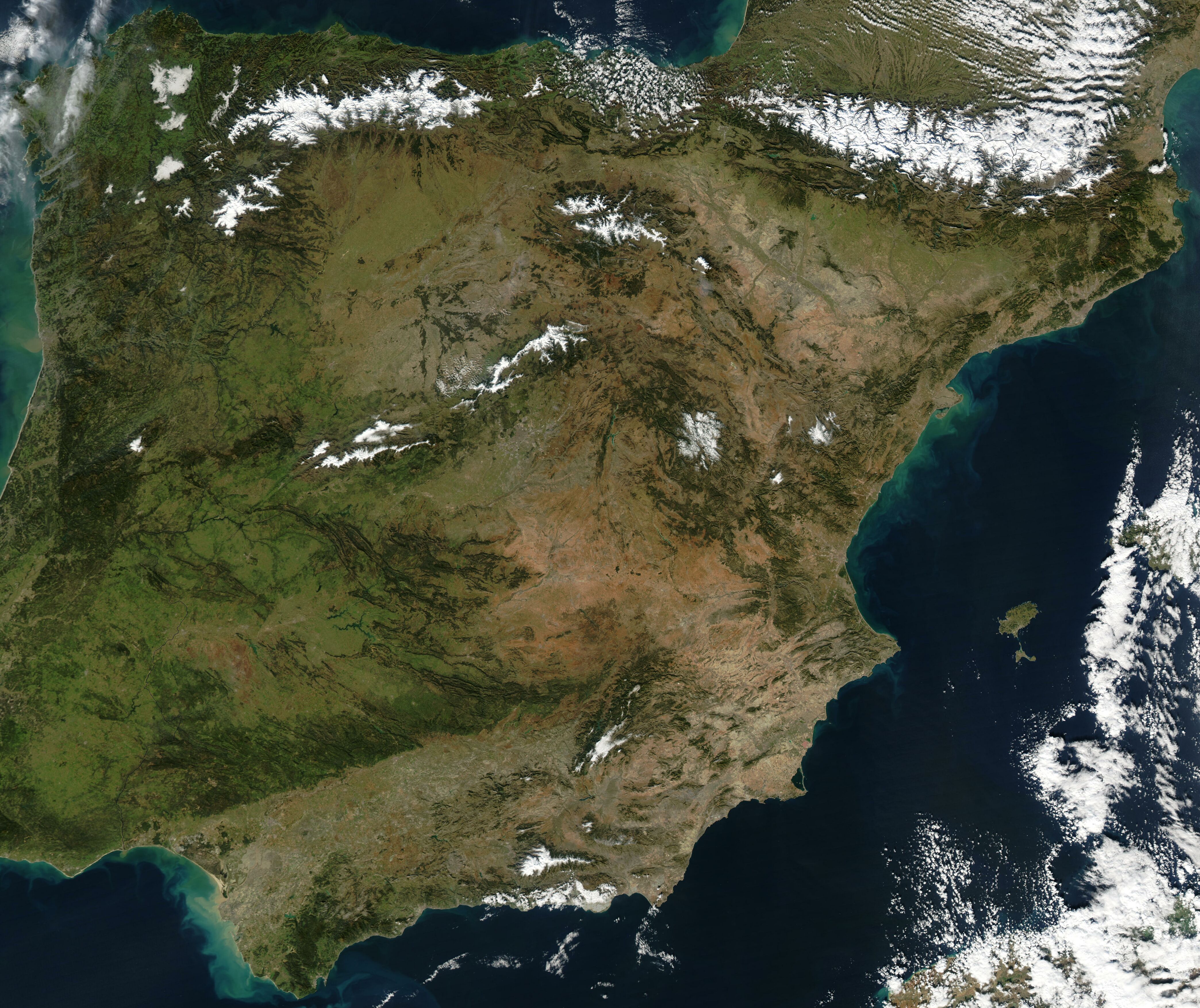
| BeschrijvingSatellite image of Spain in January 2003.jpg |
Satellite image of Spain in January 2003. Slightly cropped image, original taken from NASA's Visible Earth http://visibleearth.nasa.gov/view_rec.php?id=4989. NASA's description: The Iberian Peninsula, home to the countries of Spain and Portugal, stretches toward North Africa in this true-color Aqua MODIS image from January 24, 2003. Portugal sits on the Atlantic side of the peninsula, while Spain takes up the rest and shares a border with France to the northeast. At the bottom of the peninsula is a narrow gap between Europe and North Africa. This gap is the Strait of Gibraltar, which also serves as the buffer between the Atlantic Ocean and the Mediterranean Sea. The northern point of Morocco occupies the other side of the Strait, and farther to the east is northern Algeria. |
| Datum | |
| Bron | http://visibleearth.nasa.gov/view_rec.php?id=4989 |
| Auteur | Jacques Descloitres, MODIS Rapid Response Team, NASA/GSFC |
| Public domainPublic domainfalsefalse |
| Dit bestand bevindt zich in het publiek domein, omdat het gemaakt is door de NASA. In de reproductierichtlijnen van de NASA staat dat "NASA-materiaal niet beschermd wordt door auteursrecht, tenzij anders vermeld". | ||
 |
Waarschuwingen:
|
Bijschriften
Beschrijf in één regel wat dit bestand voorstelt
Items getoond in dit bestand
beeldt af
24 jan 2003
Bestandsgeschiedenis
Klik op een datum/tijd om het bestand te zien zoals het destijds was.
| Datum/tijd | Miniatuur | Afmetingen | Gebruiker | Opmerking | |
|---|---|---|---|---|---|
| huidige versie | 20 dec 2004 14:54 | | 4.175 × 3.508 (2,42 MB) | Hautala | {{PD-USGov-NASA}} Satellite image of Spain in January 2003. Slightly cropped image, original taken from NASA's Visible Earth http://visibleearth.nasa.gov/cgi-bin/viewrecord?24848 . Description: The Iberian Peninsula, home to the countries of Spain and Por |
Bestandsgebruik
Dit bestand wordt op de volgende 2 pagina's gebruikt:
Globaal bestandsgebruik
De volgende andere wiki's gebruiken dit bestand:
- Gebruikt op af.wikipedia.org
- Gebruikt op en.wikipedia.org
- Gebruikt op es.wikipedia.org
- Gebruikt op eu.wikipedia.org
- Gebruikt op he.wikipedia.org
- Gebruikt op ht.wikipedia.org
- Gebruikt op hu.wikipedia.org
- Gebruikt op incubator.wikimedia.org
- Gebruikt op it.wikibooks.org
- Gebruikt op it.wiktionary.org
- Gebruikt op pt.wikipedia.org
- Gebruikt op uk.wikipedia.org
Metadata
Dit bestand bevat metadata met EXIF-informatie, die door een fotocamera, scanner of fotobewerkingsprogramma toegevoegd kan zijn.
| _error | 0 |
|---|