Bestand:Tamis_banat1718_1739.png
Uit Wikipedia, de vrije encyclopedia
Grootte van deze voorvertoning: 465 × 599 pixels. Andere resoluties: 186 × 240 pixels | 373 × 480 pixels | 1.008 × 1.298 pixels.
Oorspronkelijk bestand (1.008 × 1.298 pixels, bestandsgrootte: 146 kB, MIME-type: image/png)
| Dit is een bestand van Wikimedia Commons. Onderstaande beschrijving komt van de beschrijving van het bestand daar. |
Beschrijving
| BeschrijvingTamis banat1718 1739.png |
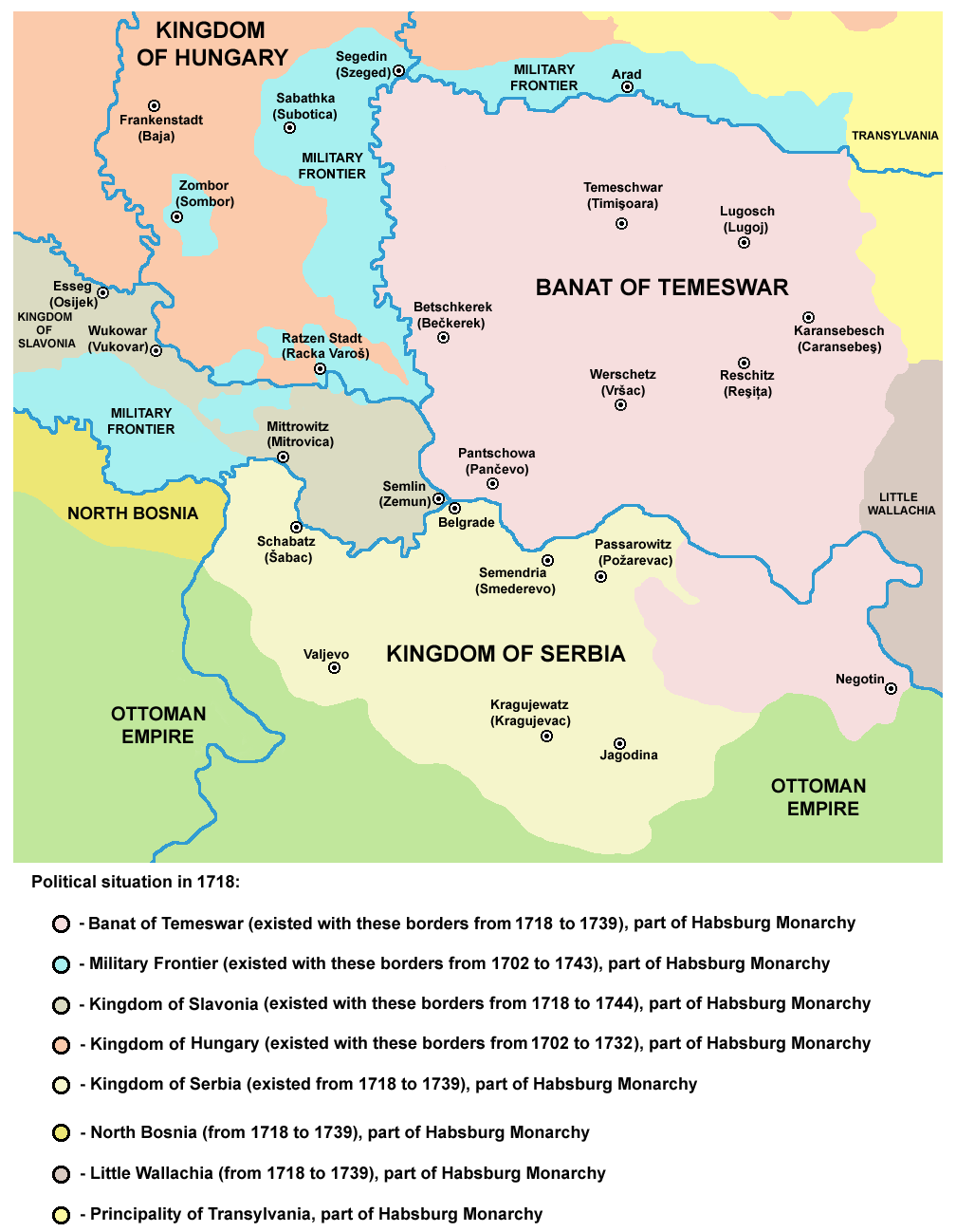
English: Map of the Banat of Temeswar, Kingdom of Serbia and Military Frontier in 1718. Serbian: Мапа Тамишког Баната, Краљевине Србије и војне границе 1718. године. |
| Datum | |
| Bron | Eigen werk |
| Auteur | PANONIAN |
Licentie
| Public domainPublic domainfalsefalse |
| Ik, de auteursrechthebbende van dit werk, geef dit werk vrij in het publieke domein. Dit is wereldwijd van toepassing. In sommige landen is dit wettelijk niet mogelijk; in die gevallen geldt: Ik sta iedereen toe dit werk voor eender welk doel te gebruiken, zonder enige voorwaarden, tenzij zulke voorwaarden door de wet worden voorgeschreven. |
References
- The Times History of Europe, Times Books, London, 2002.
- Istorijski atlas, Zavod za udžbenike i nastavna sredstva - Zavod za kartografiju "Geokarta", Beograd, 1999.
- Školski istorijski atlas, Zavod za izdavanje udžbenika Socijalističke Republike Srbije, Beograd, 1970.
- Denis Šehić - Demir Šehić, Istorijski atlas Sveta, Beograd, 2007.
- Milan Tutorov, Banatska rapsodija - istorika Zrenjanina i Banata, Novi Sad, 2001.
- Peter Rokai - Zoltan Đere - Tibor Pal - Aleksandar Kasaš, Istorija Mađara, Beograd, 2002.
- Dr Dušan J. Popović, Srbi u Vojvodini, knjiga 2, Novi Sad, 1990.
- Dr Milenko Palić, Srbi u Mađarskoj - Ugarskoj do 1918, Novi Sad, 1995.
- J. H. Šviker, Politička istorija Srba u Ugarskoj, Novi Sad - Beograd, 1998.
- Fridrih Vilhelm fon Taube, Istorijski i geografski opis Kraljevine Slavonije i Vojvodstva Srema, Novi Sad, 1998.
- Miodrag Milin, Vekovima zajedno (Iz istorije srpsko-rumunskih odnosa), Temišvar, 1995.
- Suzana Milovanović, Potiska i pomoriška vojna granica (1702-1751), Novi Sad, 2003.
- Dimitrije Boarov, Politička istorija Vojvodine, Novi Sad, 2001.
- Drago Njegovan, Prisajedinjenje Vojvodine Srbiji, Novi Sad, 2004.
- Olga Zirojević, Srbija pod turskom vlašću 1459-1804, Beograd, 2007.
- Vladimir Ćorović, Ilustrovana istorija Srba, knjiga četvrta, Beograd, 2006.
- http://www.conflicts.rem33.com/images/Ungarn/OESTEREICH%20ENTWICKLUNG.jpg
- http://terkepek.adatbank.transindex.ro/kepek/netre/51.gif
- http://upload.wikimedia.org/wikipedia/commons/8/8e/Growth_of_Habsburg_territories.jpg
- http://images.nationmaster.com/images/motw/historical/ward_1912/south_east_europe_1648.jpg archief kopie op de Wayback Machine
- http://dic.academic.ru/pictures/dewiki/80/Passarowitz_1718.JPG
- http://upload.wikimedia.org/wikipedia/commons/7/7c/Temeswarer_Banat.JPG
- http://gettysburg.cdmhost.com/cdm4/item_viewer.php?CISOROOT=/p4016coll7&CISOPTR=429&CISOBOX=1&REC=2
- http://www.garwood-voigt.com/catalogues/H22365SclavoniaeHomann.jpg
Bijschriften
Beschrijf in één regel wat dit bestand voorstelt
Items getoond in dit bestand
beeldt af
Waarde zonder Wikidata-item
image/png
Bestandsgeschiedenis
Klik op een datum/tijd om het bestand te zien zoals het destijds was.
| Datum/tijd | Miniatuur | Afmetingen | Gebruiker | Opmerking | |
|---|---|---|---|---|---|
| huidige versie | 24 jun 2014 00:47 | | 1.008 × 1.298 (146 kB) | PANONIAN | aesthetics |
| 23 jun 2014 13:07 |  | 1.008 × 1.298 (146 kB) | PANONIAN | aesthetics | |
| 12 sep 2013 11:12 |  | 1.008 × 1.298 (149 kB) | PANONIAN | correction | |
| 13 feb 2013 20:34 |  | 1.008 × 1.298 (149 kB) | PANONIAN | correction | |
| 22 dec 2012 15:15 |  | 1.008 × 1.298 (149 kB) | PANONIAN | minor aesthetical improvement | |
| 30 sep 2011 19:07 |  | 998 × 1.294 (149 kB) | PANONIAN | correction | |
| 29 sep 2011 17:47 |  | 998 × 1.294 (149 kB) | PANONIAN | correction | |
| 29 sep 2011 16:07 |  | 998 × 1.294 (149 kB) | PANONIAN | some corrections and improvements | |
| 21 dec 2009 21:52 |  | 998 × 1.206 (144 kB) | PANONIAN | {{Information |Description={{en|1=Map of the Banat of Temeswar and Military Frontier in 1718}} |Source={{own}} |Author=PANONIAN |Date= |Permission= |other_versions= }} |
Bestandsgebruik
Dit bestand wordt op de volgende 3 pagina's gebruikt:
Globaal bestandsgebruik
De volgende andere wiki's gebruiken dit bestand:
- Gebruikt op ar.wikipedia.org
- Gebruikt op az.wikipedia.org
- Gebruikt op be-tarask.wikipedia.org
- Gebruikt op be.wikipedia.org
- Gebruikt op bg.wikipedia.org
- Gebruikt op bs.wikipedia.org
- Gebruikt op ca.wikipedia.org
- Gebruikt op cs.wikipedia.org
- Gebruikt op da.wikipedia.org
- Gebruikt op de.wikipedia.org
- Gebruikt op el.wikipedia.org
- Gebruikt op en.wikipedia.org
- Gebruikt op es.wikipedia.org
- Gebruikt op eu.wikipedia.org
- Gebruikt op fa.wikipedia.org
- Gebruikt op fr.wikipedia.org
- Gebruikt op gl.wikipedia.org
- Gebruikt op he.wikipedia.org
- Gebruikt op hr.wikipedia.org
- Gebruikt op it.wikipedia.org
- Gebruikt op ko.wikipedia.org
- Gebruikt op mk.wikipedia.org
- Gebruikt op mr.wikipedia.org
- Gebruikt op nn.wikipedia.org
- Gebruikt op no.wikipedia.org
- Gebruikt op pl.wikipedia.org
Globaal gebruik van dit bestand bekijken.
Overgenomen van "https://nl.wikipedia.org/wiki/Bestand:Tamis_banat1718_1739.png"