File:WW2_Holocaust_Europe_map-de.png
Uit Wikipedia, de vrije encyclopedia
Grootte van deze voorvertoning: 721 × 600 pixels. Andere resoluties: 289 × 240 pixels | 577 × 480 pixels | 923 × 768 pixels | 1.231 × 1.024 pixels | 2.461 × 2.048 pixels | 2.729 × 2.271 pixels.
Oorspronkelijk bestand (2.729 × 2.271 pixels, bestandsgrootte: 660 kB, MIME-type: image/png)
| Dit is een bestand van Wikimedia Commons. Onderstaande beschrijving komt van de beschrijving van het bestand daar. |
Beschrijving
| BeschrijvingWW2 Holocaust Europe map-de.png |
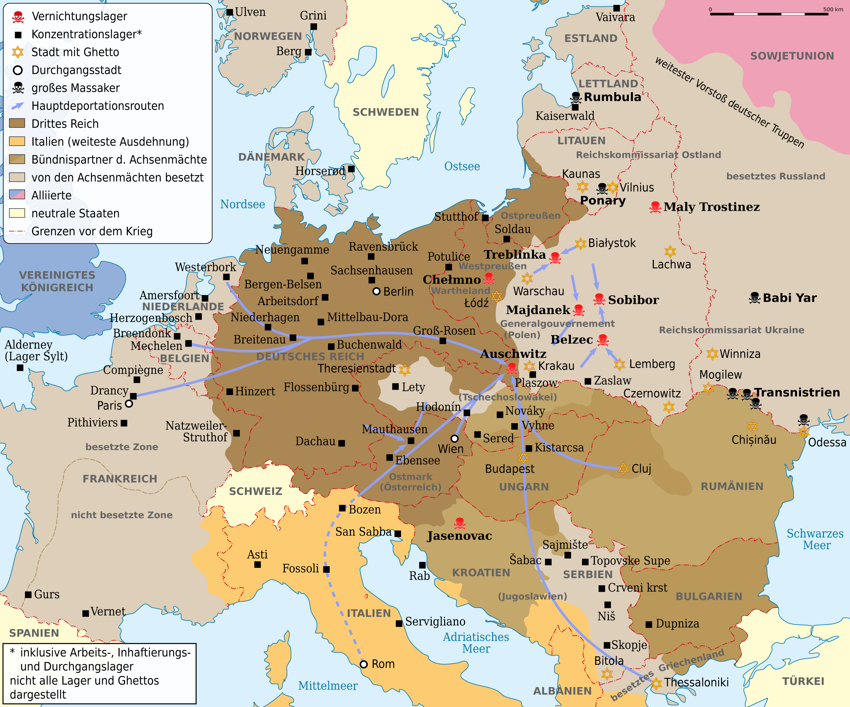
Deutsch: Karte der Vernichtungslager, der meisten großen Konzentrationslager (Arbeits-, Inhaftierungs- und Durchgangslager), der Hauptdeportationsrouten, Ghettos und Orten großer Massaker. Grenzen etwa 1942. Vor- und Nachkriegsstaatennamen in Klammern. English: Map of the extermination camps, most of the major concentration camps (labor, detention and transit camp), the main deportation routes, ghettos and places great massacre. Limits about the 1942nd Pre-and post-conflict states name in parentheses |
| Datum | |
| Bron |
Dit bestand is afgeleid van: WW2 Holocaust Europe map-fr.svg |
| Auteur |
|
| Dit is een geretoucheerde foto, wat betekent dat de originele versie digitaal aangepast is. Aanpassingen: translation. Het origineel kan hier bekeken worden: WW2 Holocaust Europe map-fr.svg. Aanpassingen gedaan door NordNordWest.
|
Licentie
Ik, de auteursrechthebbende van dit werk, maak het hierbij onder de volgende licentie beschikbaar:
| Copyleft: dit kunstwerk is vrij; u mag het heruitgeven en/of wijzigen in overeenkomst met de voorwaarden van de Free Art-licentie.
U kunt een voorbeeld van de licentie vinden op de website van Copyleft Attitude als ook op andere websites. http://artlibre.org/licence/lal/enFALFree Art Licensefalsetrue |
Oorspronkelijk uploadlogboek
This image is a derivative work of the following images:
- File:WW2_Holocaust_Europe_map-fr.svg licensed with FAL
- 2011-09-28T13:32:55Z Sémhur 1310x1090 (502755 Bytes) Location of Varsovie, border between Poland and East Prussia
- 2009-05-11T16:52:07Z Sémhur 1310x1090 (607330 Bytes) {{Information |Description=Map of the Holocaust in Europe during World War II, 1939-1945. This map shows all extermination camps (or ''death camps''), most major concentration camps, labor camps, prison camps, ghettos, major
Bijschriften
Beschrijf in één regel wat dit bestand voorstelt
Karte der Vernichtungslager, der meisten großen Konzentrationslager (Arbeits-, Inhaftierungs- und Durchgangslager), der Hauptdeportationsrouten, Ghettos und Orten großer Massaker. Grenzen etwa 1942.
Items getoond in dit bestand
beeldt af
12 sep 2012
Bestandsgeschiedenis
Klik op een datum/tijd om het bestand te zien zoals het destijds was.
| Datum/tijd | Miniatuur | Afmetingen | Gebruiker | Opmerking | |
|---|---|---|---|---|---|
| huidige versie | 1 mei 2013 10:53 | | 2.729 × 2.271 (660 kB) | NordNordWest | c |
| 14 sep 2012 10:03 |  | 2.729 × 2.271 (660 kB) | NordNordWest | c | |
| 13 sep 2012 22:45 |  | 2.729 × 2.271 (654 kB) | NordNordWest | c | |
| 12 sep 2012 21:07 |  | 2.729 × 2.271 (660 kB) | NordNordWest | == {{int:filedesc}} == {{Information |Description={{de|Karte der Vernichtungslager, der meisten großen Konzentrationslager (Arbeits-, Inhaftierungs- und Durchgangslager), der Hauptdeportationsrouten, Ghettos und Orten großer Massaker. Grenzen etwa 19... |
Bestandsgebruik
Geen enkele pagina gebruikt dit bestand.
Globaal bestandsgebruik
De volgende andere wiki's gebruiken dit bestand:
- Gebruikt op ca.wikipedia.org
- Gebruikt op de.wikipedia.org
- Deportation
- Holocaust
- Durchgangslager Fossoli
- Deutsche Besetzung Polens 1939–1945
- Konzentrationslager
- Durchgangslager Bozen
- Eichmannreferat
- Wikipedia:Kartenwerkstatt/Archiv/2012-09
- Deutsche Besetzung Frankreichs im Zweiten Weltkrieg
- Diskussion:Gesetz über das Institut des Nationalen Gedenkens – Kommission für die Verfolgung von Verbrechen gegen das Polnische Volk
- Gebruikt op ga.wikipedia.org
- Gebruikt op ksh.wikipedia.org
- Gebruikt op no.wikipedia.org
- Gebruikt op stq.wikipedia.org
- Gebruikt op uk.wikipedia.org
- Gebruikt op www.wikidata.org
Metadata
Dit bestand bevat metadata met EXIF-informatie, die door een fotocamera, scanner of fotobewerkingsprogramma toegevoegd kan zijn.
| Gebruikte software | |
|---|---|
| Horizontale resolutie | 59,06 dpc |
| Verticale resolutie | 59,06 dpc |
Overgenomen van "https://nl.wikipedia.org/wiki/Bestand:WW2_Holocaust_Europe_map-de.png"