Fil:Situation_Late_30._April_1863_and_Movements_since_27_April.jpg
From Wikipedia, the free encyclopedia
Opprinnelig fil (909 × 705 piksler, filstørrelse: 116 KB, MIME-type: image/jpeg)
| Denne filen er fra Wikimedia Commons og kan brukes av andre prosjekter. Informasjonen fra filbeskrivelsessiden vises nedenfor. |
Beskrivelse
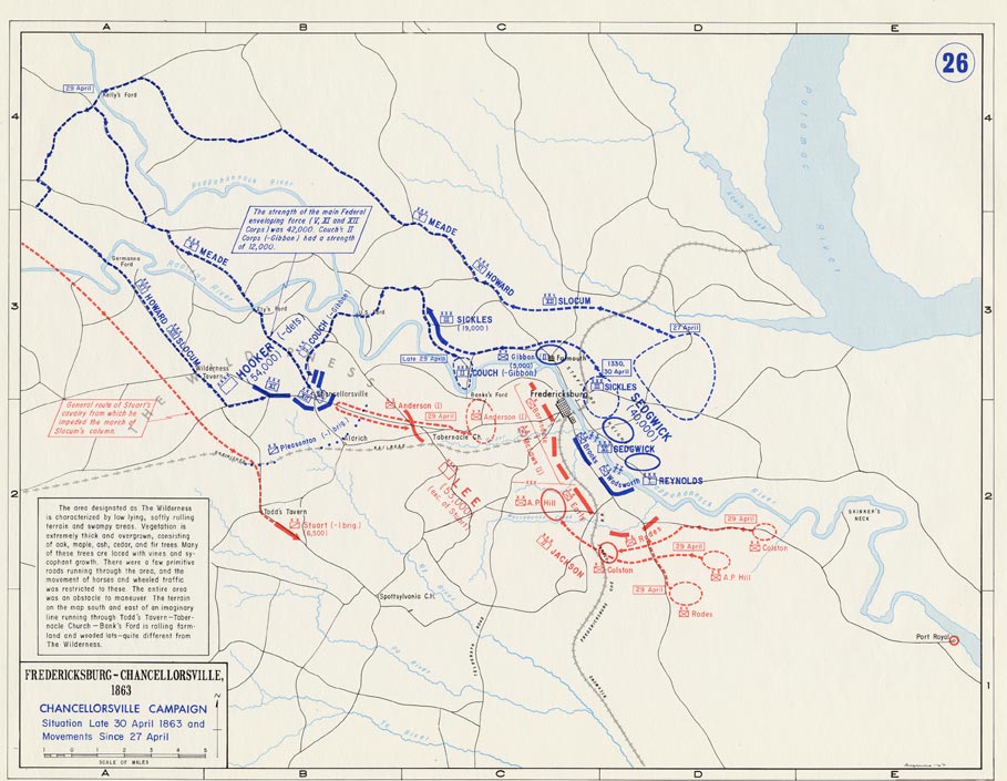
- Description: Battle of Chancellorsville, Situation Late 30. April 1863 and Movements since 27. April
- Source: www.dean.usma.edu
- Background information:
In 1938 the predecessors of what is today The Department of History at the United States Military Academy began developing a series of campaign atlases to aid in teaching cadets a course entitled, "History of the Military Art." Since then, the Department has produced over six atlases and more than one thousand maps, encompassing not only America’s wars but global conflicts as well.
In keeping abreast with today's technology, the Department of History is providing these maps on the internet as part of the department's outreach program. The maps were created by the United States Military Academy’s Department of History and are the digital versions from the atlases printed by the United States Defense Printing Agency. We gratefully acknowledge the accomplishments of the department's former cartographer, Mr. Edward J. Krasnoborski, along with the works of our present cartographer, Mr. Frank Martini.
Please be aware that these maps are large in file size and may require substantial download times.
Lisensiering
| Public domainPublic domainfalsefalse |
This file is a work of a U.S. Army soldier or employee, taken or made as part of that person's official duties. As a work of the U.S. federal government, it is in the public domain in the United States.
العربية ∙ বাংলা ∙ català ∙ čeština ∙ Deutsch ∙ English ∙ español ∙ eesti ∙ فارسی ∙ suomi ∙ français ∙ hrvatski ∙ magyar ∙ Bahasa Indonesia ∙ italiano ∙ 日本語 ∙ 한국어 ∙ lietuvių ∙ македонски ∙ മലയാളം ∙ မြန်မာဘာသာ ∙ Nederlands ∙ polski ∙ português ∙ русский ∙ sicilianu ∙ српски / srpski ∙ Türkçe ∙ українська ∙ Tiếng Việt ∙ 中文(简体) ∙ 中文(繁體) ∙ +/− |
 |
Filhistorikk
Klikk på et tidspunkt for å vise filen slik den var på det tidspunktet.
| Dato/klokkeslett | Miniatyrbilde | Dimensjoner | Bruker | Kommentar | |
|---|---|---|---|---|---|
| nåværende | 5. mai 2016 kl. 18:22 | | 909 × 705 (116 KB) | FDRMRZUSA | Reverted to version as of 19:09, 24 February 2006 (UTC) |
| 5. mai 2016 kl. 18:21 |  | 3 200 × 2 450 (5,9 MB) | FDRMRZUSA | Reverted to version as of 16:10, 5 May 2016 (UTC) | |
| 5. mai 2016 kl. 18:18 |  | 909 × 705 (116 KB) | FDRMRZUSA | Reverted to version as of 19:09, 24 February 2006 (UTC) | |
| 5. mai 2016 kl. 18:10 |  | 3 200 × 2 450 (5,9 MB) | FDRMRZUSA | New map size and design. Same license. | |
| 24. feb. 2006 kl. 21:09 |  | 909 × 705 (116 KB) | Edmund Ferman | == Summary == *Description: '''''Federal Advance, Battle of Cold Harbor, Movement to James River and Siege of Petersburg''''' *Source: [http://www.dean.usma.edu/history/web03/atlases/american%20civil%20war/acw%20pages/acw47.html www.dean.usma.edu] *Back |
Filbruk
Den følgende siden bruker denne filen:
Global filbruk
Følgende andre wikier bruker denne filen:
- Bruk i de.wikipedia.org