Simon's Town (Afrikaans: Simonstad) ke toropo hleng le Cape Town, Afrika Borwa, ke base ya South African Navy.
Quick facts Simon's Town Simonstad, Naga ...
Simon's Town
Simonstad
|
|---|
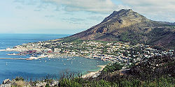 View of Simon's Town |
| Simon's Town laêditšê ka gare Kapa Bodikela
|
Location within Cape Town Lua error in Module:Location_map at line 417: Unable to find the specified location map definition. Neither "Module:Location map/data/Cape Town" nor "Template:Location map Cape Town" exists. |
| Coordinates: 34°11′36″S 18°26′00″E |
| Naga | Afrika Borwa |
|---|
| Porofense | Kapa Bodikela |
|---|
| Mmušôselegae | City of Cape Town Metropolitan Municipality|City of Cape Town |
|---|
| Hlômile | 1680 |
|---|
| Named for | Simon van der Stel |
|---|
|
| • Councillor | Simon Liell-Cock (DA) |
|---|
|
| • Total | 19.81 km2 (7.65 sq mi) |
|---|
|
| • Total | 6,569 |
|---|
| • Phitlaganyo | 330/km2 (860/sq mi) |
|---|
|
| • Bathobaso | 24.5% |
|---|
| • Bammala | 12.7% |
|---|
| • MaIndia | 4.4% |
|---|
| • Makgowa | 56.4% |
|---|
| • Šele | 2.0% |
|---|
|
|
|---|
|
| • Seisimane | 68.0% |
|---|
| • Afrikaans | 18.5% |
|---|
| • Sethosa | 3.6% |
|---|
| • Sezulu | 2.4% |
|---|
| • Šele | 7.5% |
|---|
|
|
|---|
| Nomoro ya poso (Setarata) | 7975 |
|---|
| Nomoro ya poso (Lepokisi) | 7995 |
|---|
Close
It is located on the shores of False Bay, on the eastern side of the Cape Peninsula. For more than two centuries it has been an important naval base and harbour (first for the Royal Navy and now the South African Navy). The town is named after Simon van der Stel, an early governor of the Cape Colony.


