File:Ph_locator_zamboanga_del_sur_zamboanga.png
From Wikipedia, the free encyclopedia
No higher resolution available.
Ph_locator_zamboanga_del_sur_zamboanga.png (300 × 250 pixels, file size: 11 KB, MIME type: image/png)
This file is from Wikimedia Commons and may be used by other projects. The description on its file description page there is shown below.
Sumaryo
| DeskripsionPh locator zamboanga del sur zamboanga.png |
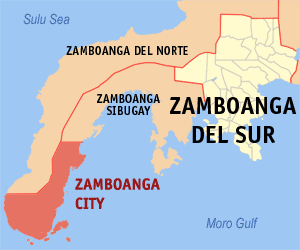
English: Map of Zamboanga Penninsula showing the location of Zamboanga City |
| Agew | |
| Pinanlapuan | English Wikipedia |
| Autor | Mike Gonzalez (TheCoffee) |
Licensing
TheCoffee, the copyright holder of this work, hereby publishes it under the following licenses:
This file is licensed under the Creative Commons Attribution-Share Alike 3.0 Unported license.
Attribution: TheCoffee
- You are free:
- to share – to copy, distribute and transmit the work
- to remix – to adapt the work
- Under the following conditions:
- attribution – You must give appropriate credit, provide a link to the license, and indicate if changes were made. You may do so in any reasonable manner, but not in any way that suggests the licensor endorses you or your use.
- share alike – If you remix, transform, or build upon the material, you must distribute your contributions under the same or compatible license as the original.

|
Permission is granted to copy, distribute and/or modify this document under the terms of the GNU Free Documentation License, Version 1.2 or any later version published by the Free Software Foundation; with no Invariant Sections, no Front-Cover Texts, and no Back-Cover Texts. A copy of the license is included in the section entitled GNU Free Documentation License.http://www.gnu.org/copyleft/fdl.htmlGFDLGNU Free Documentation Licensetruetrue |
You may select the license of your choice.
Captions
Add a one-line explanation of what this file represents
Items portrayed in this file
depicts English
copyright status English
copyrighted English
inception English
2005
media type English
image/png
File history
Click on a date/time to view the file as it appeared at that time.
| Agew/Oras | Thumbnail | Dimensions | Manguusar | Komento | |
|---|---|---|---|---|---|
| kaplesan | 15:29, 6 Nobyembre 2020 | | 300 × 250 (11 KB) | HueMan1 | Reverted to version as of 13:24, 1 January 2006 (UTC) |
| 05:03, 13 Agosto 2006 |  | 300 × 250 (12 KB) | Magalhães | updated version | |
| 13:24, 1 Enero 2006 |  | 300 × 250 (11 KB) | Magalhães | Map of Zamboanga del Sur showing the location of __. Created by TheCoffee. Released under the GNU FDL {{GFDL-en}} Category:Maps of Zamboanga del Sur |
Saray Gawing
The following page uses this file:
Global file usage
The following other wikis use this file:
- Usage on ar.wikipedia.org
- Usage on arz.wikipedia.org
- Usage on bcl.wikipedia.org
- Usage on ca.wikipedia.org
- Usage on cbk-zam.wikipedia.org
- Usage on ceb.wikipedia.org
- Usage on de.wikipedia.org
- Usage on en.wikipedia.org
- Usage on eo.wikipedia.org
- Usage on es.wikipedia.org
- Usage on eu.wikipedia.org
- Usage on fa.wikipedia.org
- Usage on fi.wikipedia.org
- Usage on fr.wikipedia.org
- Usage on gl.wikipedia.org
- Usage on hu.wikipedia.org
- Usage on id.wikipedia.org
- Usage on ilo.wikipedia.org
- Usage on incubator.wikimedia.org
- Usage on it.wikipedia.org
- Usage on ja.wikipedia.org
- Usage on ko.wikipedia.org
- Usage on la.wikipedia.org
- Usage on ms.wikipedia.org
- Usage on nl.wikipedia.org
- Usage on no.wikipedia.org
- Usage on pam.wikipedia.org
- Usage on simple.wikipedia.org
- Usage on sv.wikipedia.org
- Usage on th.wikipedia.org
View more global usage of this file.
Metadata
This file contains additional information, probably added from the digital camera or scanner used to create or digitize it.
If the file has been modified from its original state, some details may not fully reflect the modified file.
| Software used |
|
|---|