File:Iran_antique_sites.PNG
From Wikipedia, the free encyclopedia
اڃان سنھو تحلل ميسر ناھي.
Iran_antique_sites.PNG (672 × 600 عڪسلون، فائيل سائيز: 121 KB، MIME ٽائيپ: image/png)
ھي فائيل وڪيميڊيا العام مان آھي ۽ ٻين رٿائن پاران پڻ استعمال ٿي سگهي ٿو. تشريح انجي [فائيل جي تشريحي صفحي] ھيٺان ڏنل آھي.
| تشريحIran antique sites.PNG |
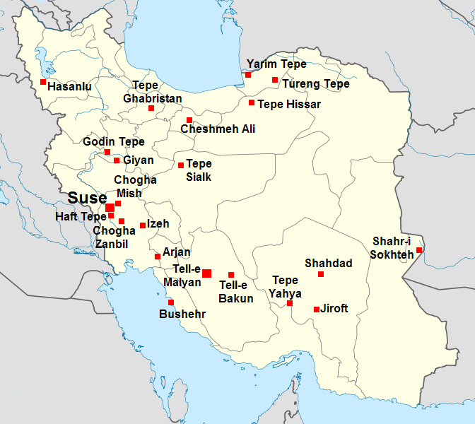
English: Map locating the major archaeological sites of Iran during the 3rd to 2d millennium B.C.
Français : Carte localisant les principaux sites archéologiques de l'Iran des IIIe-IIe millénaires av. J.-C. |
| تاريخ | (UTC) |
| ذريعو | |
| ليکڪ |
|
| This is a retouched picture, which means that it has been digitally altered from its original version. Modifications: Ajout des sites archéologiques.. The original can be viewed here: Iran location map.svg:
|
I, the copyright holder of this work, hereby publish it under the following licenses:
ھي فائيل ڪريئيٽو ڪامنز انتساب-ھڪجھڙي ڀاڱيداري 3.0 انپورٽڊ اجازتنامي ھيٺ اجازتنامو ڏنل آھي.
- توھان آزاد آھيو:
- ونڊڻ لاءِ – اھو ڪم نقل ڪرڻ، ورڇڻ، ۽ پارمڪارڻ
- جڳلبندي ڪرڻ – ڪم اختيار ڪرڻ لاءِ
- ھيٺين شرطن تي:
- انتساب – توهان لازماً مناسب انتساب ڏيو، اجازتنامي ڏانھن ڳنڍڻو مھيا ڪريو، ۽ جيڪڏھن ڪي تبديليون ڪيون ويون ھجن تہ انھن جي نشاندھي ڪريو. توهان اهو ڪري سگهو ٿا ڪنھن بہ معقول طريقي سان، پر ڪنھن بہ اھڙي طريقي سان نہ جيڪو ڏسي تہ اجازتنامو ڏيندڙ توهان جي يا توهان جي استعمال جي توثيق ڪري ٿو.
- ھڪجھڙي ڀاڱيداري – جيڪڏھن توھان ٻيھر ملاوٽ، بدلاءُ، يا مواد تي اڏاوت ڪريو ٿا، توھان کي لازماً پنھنجون ڀاڱيداريون ساڳي يا موافق اجازتنامي جھڙو اصل جو ھيو، ھيٺ ٻيھر-ورھائڻ گهرجن.

|
ھن دستاويز کي جي.اين.يو مفت دستاويزسازي اجازتنامي ، مفت سافٽويئر فائونڊيشن پاران ڇاپيل ورزن 1.2 يا ٻي ڪنھن بعد واري ورزن؛ جنھن ۾ نہ انويريئينٽ ڀاڱا، ۽ نہ فونٽ-ڪور متنَ، ۽ نہ بيڪ-ڪور متنَ شامل آھن، جي شرطن ھيٺ نقل ڪرڻ، ورھائن ۽/يا بدلائڻ جي اجازت ڏني وئي آھي. اجازتنامي جو نقل [[c:Commons:GNU Free Documentation License, version 1.2 | جي.اين.يو مفت دستاويزسازي اجازتنامو]] نالي ڀاڱي ۾ ڏنل آھي.http://www.gnu.org/copyleft/fdl.htmlGFDLGNU Free Documentation Licensetruetrue |
توھان پنھنجي پسند جو اجازتنامو چونڊي سگهو ٿا.
Original upload log
This image is a derivative work of the following images:
- File:Iran_location_map.svg licensed with Cc-by-sa-3.0, GFDL
- 2010-07-11T20:08:23Z Uwe Dedering 1200x1071 (655114 Bytes) 31. province Alborz
- 2010-02-18T17:44:29Z Uwe Dedering 1200x1071 (721726 Bytes) Bahrain above water, no disputed countries
- 2010-02-18T13:00:48Z Uwe Dedering 1200x1071 (725716 Bytes) {{Information |Description={{en|1=Location map of Iran. Equirectangular projection. Strechted by 118.0%. Geographic limits of the map: * N: 40.0° N * S: 24.5° N * W: 43.5° E * E: 64.0° E Made with Natural Earth. Fre
Uploaded with derivativeFX
عنوان
ھڪ-سٽي وضاحت ڏيو تہ ھي فائيل ڇاکي ٿو ظاھر ڪري
Items portrayed in this file
depicts انگريزي
copyright status انگريزي
copyrighted انگريزي
inception انگريزي
5 سيپٽمبر 2010
فائيل جي سوانح
ڪنھن بہ تاريخ/وقت تي ٽڙڪ ڪري ڏسندا تہ ان وقت اهو فائيل ڪيئن هو.
| تاريخ/وقت | آڱوٺي ننھن | ماپَ | واپرائيندڙ | راءِ | |
|---|---|---|---|---|---|
| موجود نسخو | 20:33, 5 سيپٽمبر 2010 | | 672 × 600 (121 KB) | Zunkir | Ajout d'un nouveau site (Shahdad). |
| 20:31, 5 سيپٽمبر 2010 |  | 672 × 600 (121 KB) | Zunkir | {{Information |Description={{en|Map locating the major archaeological sites of Iran during the 3rd to 2d millennium B.C.}} {{fr|Carte localisant les principaux sites archéologiques de l'Iran des {{IIIe}}-{{IIe}} millénaires av. J.-C.}} |Source=*[[:File |
ڳنڍڻا
ڪي بہ صفحا ناھن جيڪي ھن فائيل کي استعمال ڪندا ھجن.
گلوبل فائيل جو استعمال
ھيٺيون وڪيز بہ ھيءُ فائيل استعمال ڪن ٿيون:
- de.wikipedia.org تي استعمال
- fr.wikipedia.org تي استعمال
- lt.wikipedia.org تي استعمال
- sl.wikipedia.org تي استعمال