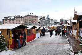
Einsiedeln
municipality in the canton of Schwyz in Switzerland From Wikipedia, the free encyclopedia
Einsiedeln is a municipality and district in the canton of Schwyz in Switzerland. It is known for its monastery, the Benedictine Einsiedeln Abbey, founded in the 10th century.
Einsiedeln | |
|---|---|
 | |
| Coordinates: 47°7′N 8°44′E | |
| Country | Switzerland |
| Canton | Schwyz |
| District | Einsiedeln |
| Area | |
| • Total | 110.40 km2 (42.63 sq mi) |
| Elevation | 882 m (2,894 ft) |
| Population (31 December 2018)[2] | |
| • Total | 15,867 |
| • Density | 140/km2 (370/sq mi) |
| Time zone | UTC+01:00 (Central European Time) |
| • Summer (DST) | UTC+02:00 (Central European Summer Time) |
| Postal code(s) | 8840 |
| SFOS number | 1301 |
| Localities | Bennau, Egg, Euthal, Gross, Trachslau, Willerzell and Biberbrugg (shared with the municipality Feusisberg) |
| Surrounded by | Alpthal, Altendorf, Feusisberg, Freienbach, Innerthal, Oberägeri (ZG), Oberiberg, Rothenthurm, Unteriberg, Vorderthal |
| Website | www SFSO statistics |
Villages
The municipality has six villages: Bennau, Egg, Willerzell, Euthal, Gross and Trachslau. The village of Biberbrugg is shared with the municipality of Feusisberg.
References
Other websites
Wikiwand in your browser!
Seamless Wikipedia browsing. On steroids.
Every time you click a link to Wikipedia, Wiktionary or Wikiquote in your browser's search results, it will show the modern Wikiwand interface.
Wikiwand extension is a five stars, simple, with minimum permission required to keep your browsing private, safe and transparent.


