File:7_zones_dels_ciclons_tropicals.jpg
From Wikipedia, the free encyclopedia
Size of this preview: 800 × 332 pixels. Other resolutions: 320 × 133 pixels | 640 × 265 pixels | 1,780 × 738 pixels.
Original file (1,780 × 738 pixels, file size: 273 KB, MIME type: image/jpeg)
| This is a file from the Wikimedia Commons. Information from its description page there is shown below. Commons is a freely licensed media file repository. You can help. |
| Description7 zones dels ciclons tropicals.jpg |
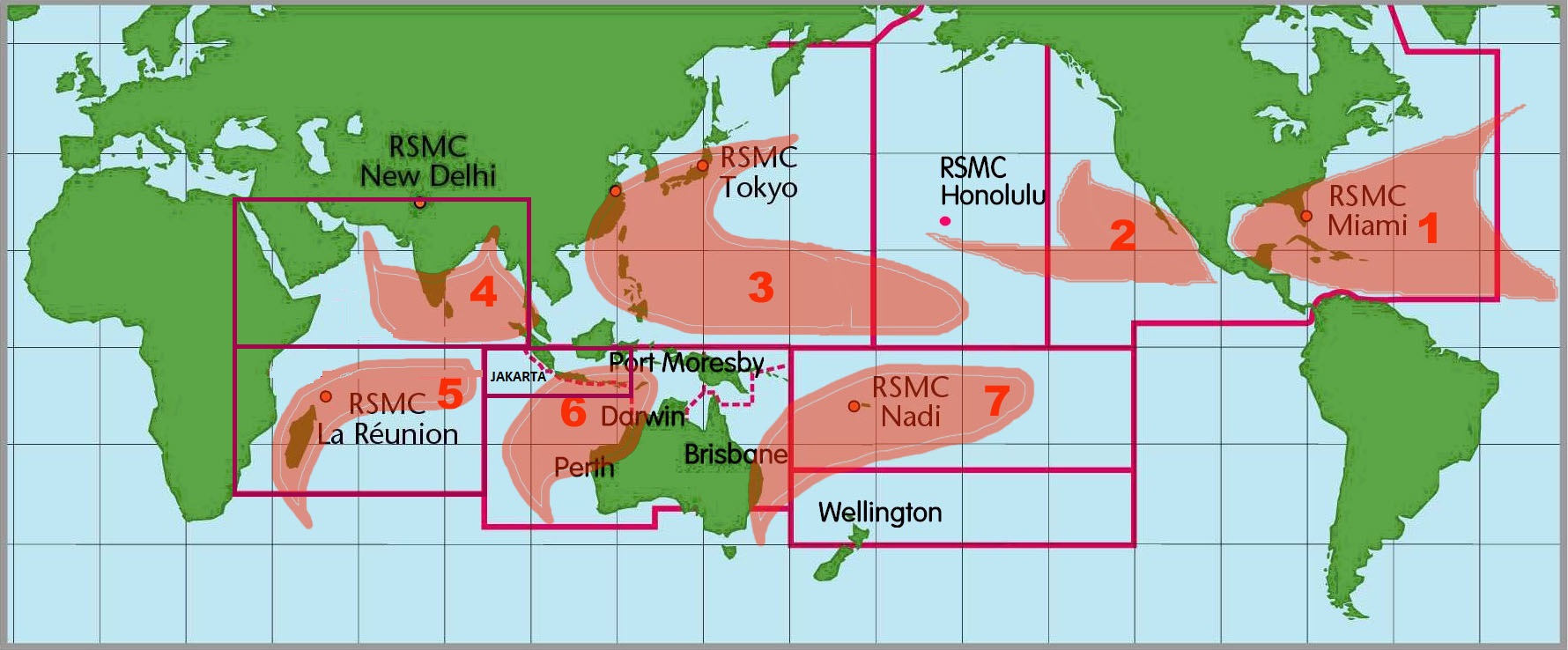
English: Images of the seven tropical cyclone basins where storms occur on a regular basis around the world and the corresponding Regional Specialized Meteorological Center.
Català: Mapamundi amb les 7 àrees on s'originen ciclons tropicals. |
||||
| Date | (UTC) | ||||
| Source | Atlantic Oceanographic and Meteorological laboratory | ||||
| Author | National Oceanic and Atmospheric Administration | ||||
| Permission (Reusing this file) |
|
||||
| Other versions | Image:6RSMCs.jpg |

|
This meteorology image could be re-created using vector graphics as an SVG file. This has several advantages; see Commons:Media for cleanup for more information. If an SVG form of this image is available, please upload it and afterwards replace this template with
{{vector version available|new image name}}.
It is recommended to name the SVG file “7 zones dels ciclons tropicals.svg”—then the template Vector version available (or Vva) does not need the new image name parameter. |
 | This meteorology image was uploaded in the JPEG format even though it consists of non-photographic data. This information could be stored more efficiently or accurately in the PNG or SVG format. If possible, please upload a PNG or SVG version of this image without compression artifacts, derived from a non-JPEG source (or with existing artifacts removed). After doing so, please tag the JPEG version with {{Superseded|NewImage.ext}} and remove this tag. This tag should not be applied to photographs or scans. If this image is a diagram or other image suitable for vectorisation, please tag this image with {{Convert to SVG}} instead of {{BadJPEG}}. If not suitable for vectorisation, use {{Convert to PNG}}. For more information, see {{BadJPEG}}. |  |
Captions
Add a one-line explanation of what this file represents
Items portrayed in this file
depicts
22 October 2005
image/jpeg
56c685f2c6f5bf05cf72937b04a758dc866d2a33
279,321 byte
738 pixel
1,780 pixel
File history
Click on a date/time to view the file as it appeared at that time.
| Date/Time | Thumbnail | Dimensions | User | Comment | |
|---|---|---|---|---|---|
| current | 02:34, 6 June 2010 | | 1,780 × 738 (273 KB) | Jason Rees | Updated the basin boundaries Added Jakarta and updated RSMC New Delhi's Perth and Reunions boundaries. |
| 00:08, 22 October 2005 |  | 1,780 × 738 (211 KB) | Xadaga | {{DP-NOAA}} Mapamundi amb les 7 àrees on s'originen ciclons tropicals. Imatge extreta de la NOAA. [http://www.aoml.noaa.gov/hrd/tcfaq/F1.html] |
File usage
The following page uses this file:
Global file usage
The following other wikis use this file:
- Usage on ca.wikipedia.org
- Usage on de.wikipedia.org
- Usage on en.wikivoyage.org
- Usage on es.wikipedia.org
- Usage on es.wikivoyage.org
- Usage on fr.wikipedia.org
- Usage on he.wikivoyage.org
- Usage on ja.wikipedia.org
- Usage on ko.wikipedia.org
- Usage on ms.wikipedia.org
- Usage on no.wikipedia.org
- Usage on pt.wikipedia.org
- Usage on ru.wikipedia.org
- Usage on sh.wikipedia.org
- Usage on sr.wikipedia.org
- Usage on th.wikipedia.org
- Usage on uk.wikipedia.org
- Usage on zh-yue.wikipedia.org
- Usage on zh.wikipedia.org