Auvergne-Rhône-Alpes
French administrative region From Wikipedia, the free encyclopedia

Remove ads
Auvergne-Rhône-Alpes (Franco-Provençal: Ôvèrgne-Rôno-Ârpes; Occitan: Auvèrnhe Ròse Aups) is an administrative region of France that was created on 1 January 2016 from the former French regions Auvergne and Rhône-Alpes. It is in the central and eastern parts of southern France.
.jpg)


Remove ads
Geography
The Auvergne-Rhône-Alpes region is the third largest region of Metropolitan France, after Nouvelle-Aquitaine and Occitanie, with an area of 69,711.2 km2 (26,916 sq mi). It borders five French administrative regions: Bourgogne-Franche-Comté to the north, Centre-Val de Loire to the northwest, Nouvelle-Aquitaine to the west, Occitanie to the southwest and Provence-Alpes-Côte d'Azur to the southeast. It also borders two countries: Italy to the east and Switzerland to the northeast.
The region has the Massif Central to the east and the Alps to the east, with the valley of the Rhône river between them. Half of the Ain department is occupied by the Jura Mountains.
The extreme points for the region are in the communes:
- North : Château-sur-Allier, Allier (46.804272°N 2.959629°E)
- East : Bonneval-sur-Arc, Savoie (45.403287°N 7.185578°E)
- South : Ferrassières, Drôme (44.115494°N 5.494467°E)
- West : Siran, Cantal (44.976621°N 2.062885°E)
Its capital, Lyon, is at 465 km (289 mi) to the southwest of Paris, the national capital, at 315 km (196 mi) to the northwest of Marseille and at 554 km (344 mi) to the west of Bordeaux.
The distances from the different departmental capitals to Lyon, the regional capital, are:
- Bourg-en-Bresse (Ain) - 81 km (50 mi)
- Moulins (Allier) - 204 km (127 mi)
- Privas (Ardèche) - 142 km (88 mi)
- Aurillac (Cantal) - 314 km (195 mi)
- Valence (Drôme) - 102 km (63 mi)
- Grenoble (Isère) - 106 km (66 mi)
- Saint-Étienne (Loire) - 63 km (39 mi)
- Le Puy-en-Velay (Haute-Loire) - 134 km (83 mi)
- Clermont-Ferrand (Puy-de-Dôme) - 164 km (102 mi)
- Chambéry (Savoie) - 99 km (62 mi)
- Annecy (Haute-Savoie) - 101 km (63 mi)
Rivers
There are two main drainage basin in the region; some rivers in those basins are:
Mountains
The Mont Blanc (42°46′26″N 0°8′51″E), at 4,810 m (15,780 ft), is the highest mountain of the Auvergne-Rhône-Alpes region, France, Italy and of Western Europe.[3]
The highest points in the different departments of the Auvergne-Rhône-Alpes region are:[4]
Remove ads
Departments
The Auvergne-Rhône-Alpes region is formed by 13 departments and one territorial collectivity with the same powers as a department.
Arr. = Arrondissements Cant. = Cantons Comm. = Communes
Remove ads
Demographics
The Auvergne-Rhône-Alpes region had a population, in 2014, of 7,820,966,[6] for a population density of 112.2 inhabitants/km2. The department with more people living in it is Rhône with 1,801,885 inhabitants.
The main cities in the region are:
Gallery
 The valley of the Rhône river.
 South side of the Mont Blanc.
 Fourvière Basilica (Lyon) viewed from the Saône river.
 Overview on Lyon during Fête des Lumières.
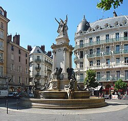 Fountain of the Three Orders, Grenoble


.jpg)


Related pages
References
Other websites
Wikiwand - on
Seamless Wikipedia browsing. On steroids.
Remove ads