The Dnieper River is one of the major rivers in Europe. It flows from Russia, through Belarus and Ukraine, to the Black Sea. It is fourth largest by length in Europe. Its total length is 2,285 kilometres (1,420 mi). 485 km (301 mi) is in Russia, 595 km (370 mi) is in Belarus, and 1,095 km (680 mi) is in Ukraine. Its basin covers 504,000 square kilometres (195,000 sq mi). 289,000 km2 (112,000 sq mi) is in Ukraine. In antiquity, it was known to the Greeks as the Borysthenes.
Quick facts Location, Country ...
Dnipro
Russian: Днепр (Dnepr)
Belarusian: Дняпро (Dnyapro)
Ukrainian: Дніпро (Dnipro) |
|---|
 |
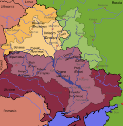 Dnieper River drainage basin |
|
| Country | Russia, Belarus, Ukraine |
|---|
| Cities | Dorogobuzh, Smolensk, Mogilev, Kyiv, Cherkasy, Dnipro, Zaporizhia |
|---|
|
|
| Source | |
|---|
| - location | Valdai Hills, Russia |
|---|
| - coordinates | 55°52′00″N 33°41′00″E |
|---|
| - elevation | 220 m (720 ft) |
|---|
|
|
| Mouth | Dnipro Delta |
|---|
| - location | Ukraine |
|---|
| - coordinates | 46°30′00″N 32°20′00″E |
|---|
| - elevation | 0 m (0 ft) |
|---|
| Length | 2,201 km (1,368 mi) |
|---|
| Basin size | 504,000 km2 (195,000 sq mi) |
|---|
|
| Discharge | |
|---|
| - location | Kherson |
|---|
| - average | 1,670 m3/s (59,000 cu ft/s) |
|---|
|
|
|
| Tributaries | |
|---|
| - left | Sozh, Desna, Trubizh, Supiy, Sula, Psel, Vorskla, Samara, Konka, Bilozerka |
|---|
| - right | Drut, Berezina, Prypiat, Teteriv, Irpin, Stuhna, Ros, Tiasmyn, Bazavluk, Inhulets |
|---|
| Protection status | |
|---|
|
| Official name | Dnieper River Floodplain |
|---|
| Designated | 29 May 2014 |
|---|
| Reference no. | 2244[1] |
|---|
|
|
|---|
|
|
Close
Settlements next to the Dnieper
Towns/villages
blank spaces indicate as place above (") |
|
|
|
Bocharovo |
|
|
Verkhnedneprovsky |
|
|
Dorogobuzh |
|
|
Smolensk |
| Russia-Belarus border |
|
|
|
|
Dubroŭna |
|
|
Orsha |
|
|
Kopys |
|
|
Shkloŭ |
|
|
Mogilev |
|
|
Bykhaw |
|
|
Rahachow |
|
|
Žlobin |
|
|
Streshin |
|
|
Rečyca |
|
|
Loyew |
|
|
Komarin |
| Belarus-Ukraine border |
|
|
|
|
Radul |
|
|
Liubech |
|
|
Vyshhorod |
|
|
Kyiv Hydroelectric Power Plant |
|
|
Kyiv |
|
|
Kozyn |
|
|
Ukrainka |
|
|
Rzhyshchiv |
|
|
Pereiaslav-Khmelnytskyi |
| Kaniv |
|
Kaniv Hydroelectric Power Plant |
|
|
Cherkasy |
|
|
Svitlovodsk |
| Kremenchuk |
|
Kremenchuk Hydroelectric Power Plant |
|
|
Horishni Plavni |
|
|
Verkhnodniprovsk |
| Kamianske |
|
Middle Dnieper Hydroelectric Power Plant |
|
|
Dnipro |
| Zaporizhia |
|
Dnieper Hydroelectric Station |
|
|
Vasylivka |
|
|
Dniprorudne |
|
|
Enerhodar |
|
|
Nikopol |
|
|
Kamianka-Dniprovska |
|
|
Novovorontsovka |
|
|
Velyka Lepetyha |
|
|
Hornostayivka |
|
|
Beryslav |
| Kakhovka |
|
Kakhovka Hydroelectric Power Plant |
|
|
Nova Kakhovka |
|
|
Dnipriany |
|
|
Oleshky |
|
|
Kherson |
|
|
Bilozerka |
|
|
Hola Prystan |
|
|
Ochakiv |
End of Dnieper Estuary — Black Sea
(the few settlements further along the debatable estuary
to the two points mentioned in the routemap are on inlets or far inland) |
|
|
|
The river is part of the Quagga mussel's native range.


