Súbor:Gulf_of_Saint_Lawrence.jpg
From Wikipedia, the free encyclopedia
Nie je dostupné vyššie rozlíšenie.
Gulf_of_Saint_Lawrence.jpg (734 × 456 pixelov, veľkosť súboru: 99 KB, MIME typ: image/jpeg)
Tento zdieľaný súbor je z Wikimedia Commons a je možné ho používať na iných projektoch. Nižšie sú zobrazené informácie z popisnej stránky súboru.
Zhrnutie
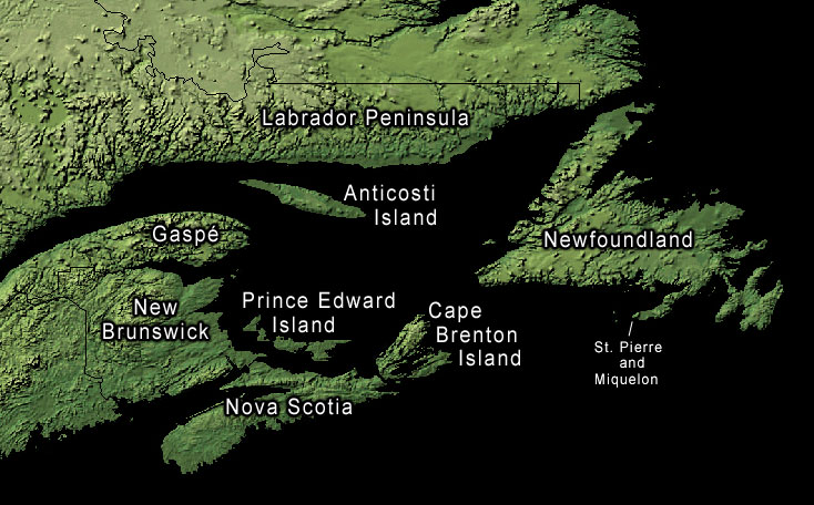
Land-cover imagery from USGS's National Map Server archive copy at the Wayback Machine. Photoshop file with layers is located here in case any modifications or translations are needed.
Licencovanie
| Public domainPublic domainfalsefalse |
Toto dílo je ve Spojených státech volným dílem, protože jde o dílo úřadů americké federální vlády podle ustanovení Hlavy 17, Kapitoly 1, Sekce 105 amerického právního řádu. Viz Autorské právo.
Upozornění: uvedené se vztahuje pouze na díla úřadů federální vlády, nikoliv na úřady jednotlivých států, okresů, či nižších územně správních jednotek.
|
 | |
| Tento súbor bol identifikovaný, že nemá žiadne známe obmedzenia vyplývajúce z autorského zákona vrátane všetkých súvisiacich a susedných práv. | ||
https://creativecommons.org/publicdomain/mark/1.0/PDMCreative Commons Public Domain Mark 1.0falsefalse
Pôvodný záznam nahrávaní
The original description page was here. All following user names refer to en.wikipedia.
- 2006-01-30 20:43 Kelisi 734×456× (74652 bytes) same, with spelling correction
- 2005-10-23 17:10 Interiot 734×456× (101750 bytes) inc font size of "Gaspé"
- 2005-10-23 15:38 Interiot 734×456× (101801 bytes) more font tweaks
- 2005-10-23 15:32 Interiot 734×457× (101689 bytes) larger font
- 2005-10-23 15:26 Interiot 781×481× (111492 bytes) Map of the [[Gulf of Saint Lawrence]]. Land-cover imagery from [[USGS]]'s [http://nmviewogc.cr.usgs.gov/viewer.htm National Map Server].
História súboru
Po kliknutí na dátum/čas uvidíte ako súbor vyzeral vtedy.
| Dátum/Čas | Náhľad | Rozmery | Používateľ | Komentár | |
|---|---|---|---|---|---|
| aktuálna | 22:23, 17. september 2012 | | 734 × 456 (99 KB) | OgreBot | (BOT): Reverting to most recent version before archival |
| 22:23, 17. september 2012 |  | 734 × 456 (73 KB) | OgreBot | (BOT): Uploading old version of file from en.wikipedia; originally uploaded on 2006-01-30 20:43:20 by Kelisi | |
| 22:23, 17. september 2012 |  | 734 × 456 (99 KB) | OgreBot | (BOT): Uploading old version of file from en.wikipedia; originally uploaded on 2005-10-23 15:38:39 by Interiot | |
| 22:23, 17. september 2012 |  | 734 × 457 (99 KB) | OgreBot | (BOT): Uploading old version of file from en.wikipedia; originally uploaded on 2005-10-23 15:32:33 by Interiot | |
| 22:23, 17. september 2012 |  | 781 × 481 (109 KB) | OgreBot | (BOT): Uploading old version of file from en.wikipedia; originally uploaded on 2005-10-23 15:26:46 by Interiot | |
| 08:05, 29. január 2006 |  | 734 × 456 (99 KB) | Kpjas | Land-cover imagery from USGS's [http://nmviewogc.cr.usgs.gov/viewer.htm National Map Server]. Photoshop file with layers is located [http://paperlined.org/apps/wikipedia/src_data/Gulf_of_Saint_Lawrence.psd here] in case any modifications or trans |
Použitie súboru
Na tento súbor odkazuje nasledujúca stránka:
Globálne využitie súborov
Nasledovné ďalšie wiki používajú tento súbor:
- Použitie na af.wikipedia.org
- Použitie na az.wikipedia.org
- Použitie na ba.wikipedia.org
- Použitie na be.wikipedia.org
- Použitie na bs.wikipedia.org
- Použitie na ce.wikipedia.org
- Použitie na cs.wikipedia.org
- Použitie na el.wikipedia.org
- Použitie na en.wikipedia.org
- Použitie na fa.wikipedia.org
- Použitie na fr.wikipedia.org
- Použitie na he.wikipedia.org
- Použitie na id.wikipedia.org
- Použitie na it.wikipedia.org
- Použitie na ko.wikipedia.org
- Použitie na lv.wikipedia.org
- Použitie na pl.wikipedia.org
- Použitie na ro.wikipedia.org
- Použitie na ru.wikipedia.org
- Použitie na sh.wikipedia.org
- Použitie na sr.wikipedia.org
- Použitie na uk.wikipedia.org
- Použitie na zh.wikipedia.org