Súbor:Roman_expansion_264_BC_Shepherd.jpg
From Wikipedia, the free encyclopedia
Pôvodný súbor (2 302 × 1 812 pixelov, veľkosť súboru: 873 KB, MIME typ: image/jpeg)
Tento zdieľaný súbor je z Wikimedia Commons a je možné ho používať na iných projektoch. Nižšie sú zobrazené informácie z popisnej stránky súboru.
This image was copied from wikipedia:de. The original description was:
| PopisRoman expansion 264 BC Shepherd.jpg |
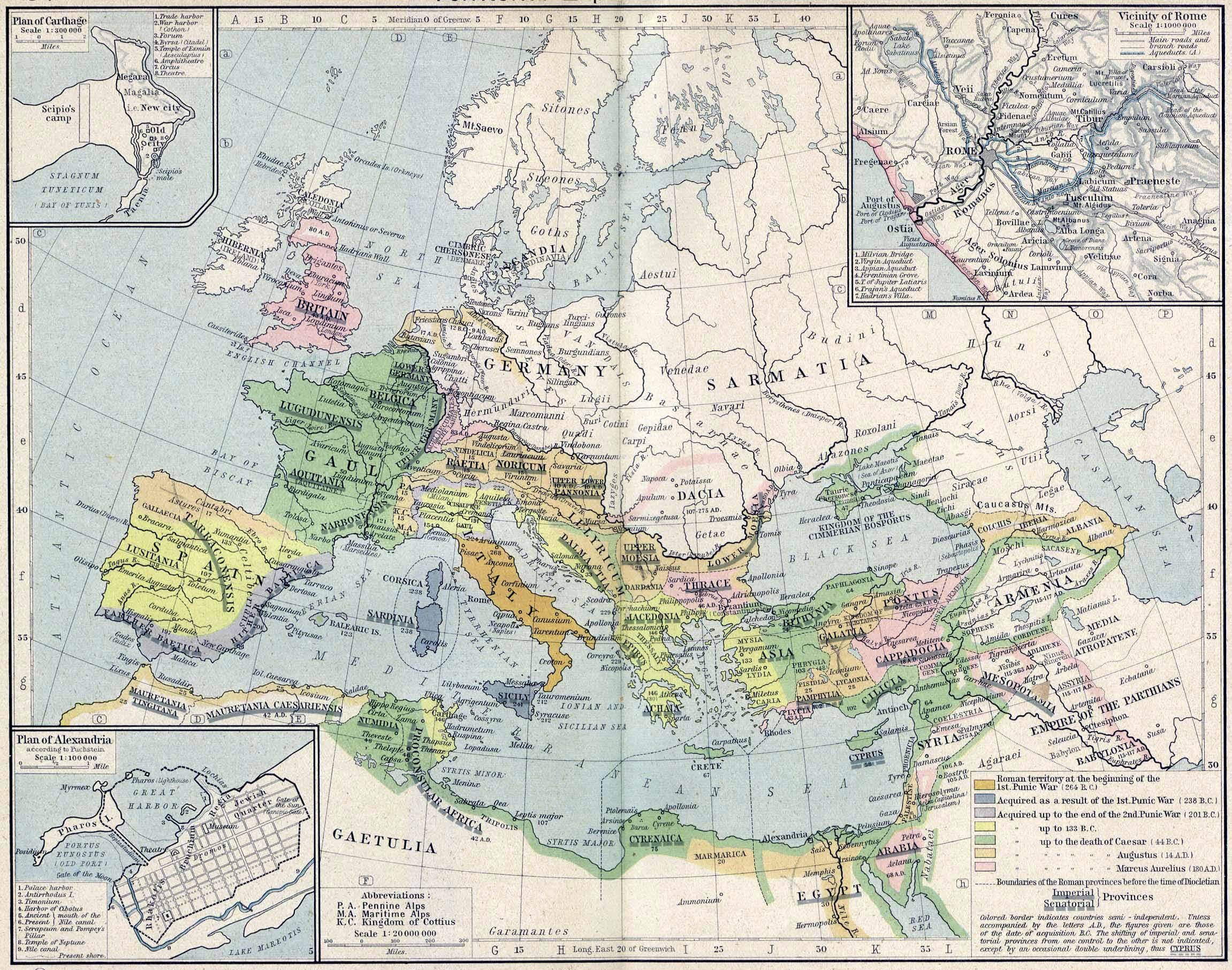
English: Roman territory, from the beginning of the 1st punic war (264 B.C.) to the death of Diocletian
Deutsch: Römisches Reich vom Beginn des 1. Punischen Kriegs (264 v.Chr.) bis zum Tod von Diokletian (312) im Historischen Atlas von William R. Shepherd (1923) |
|||
| Dátum | 1923 | |||
| Zdroj | "Historical Atlas" by William R. Shepherd, New York, Henry Holt and Company | |||
| Autor | William R. Shepherd | |||
| Ďalšie verzie |
|
| Public domainPublic domainfalsefalse |
|
Toto dílo je volné také v zemích, jejichž právní řád chrání majetková autorská práva po dobu života autora a 70 let po jeho smrti.
| |
| Tento súbor bol identifikovaný, že nemá žiadne známe obmedzenia vyplývajúce z autorského zákona vrátane všetkých súvisiacich a susedných práv. | |
https://creativecommons.org/publicdomain/mark/1.0/PDMCreative Commons Public Domain Mark 1.0falsefalse
| date/time | username | edit summary |
|---|---|---|
| 18:08, 21. Feb 2005 | Benowar | ("Historical Atlas" by William R. Shepherd, New York, Henry Holt and Company, 1923 PUBLIC DOMAIN) |
Štítky
Položky prezentované týmto súborom
motív
image/jpeg
História súboru
Po kliknutí na dátum/čas uvidíte ako súbor vyzeral vtedy.
| Dátum/Čas | Náhľad | Rozmery | Používateľ | Komentár | |
|---|---|---|---|---|---|
| aktuálna | 17:08, 18. apríl 2006 | | 2 302 × 1 812 (873 KB) | Crux | verbesserte Version |
| 16:53, 18. apríl 2006 |  | 2 302 × 1 812 (767 KB) | Crux | This image was copied from wikipedia:de. The original description was: {{Information| |Description=Roman territory at the beginning of the 1st punic war (264 B.C.) |Source="Historical Atlas" by William R. Shepherd, New York, Henry Holt and Company |Date= |
Použitie súboru
Na tento súbor odkazuje nasledujúca stránka:
Globálne využitie súborov
Nasledovné ďalšie wiki používajú tento súbor:
- Použitie na ast.wikipedia.org
- Použitie na ba.wikipedia.org
- Použitie na bn.wikipedia.org
- Použitie na br.wikipedia.org
- Použitie na ca.wikipedia.org
- Použitie na de.wikipedia.org
- Použitie na de.wikibooks.org
- Použitie na en.wikipedia.org
- Použitie na es.wikipedia.org
- Použitie na fr.wikipedia.org
- Použitie na fy.wikipedia.org
- Použitie na it.wikipedia.org
- Použitie na it.wikibooks.org
- Použitie na lv.wikipedia.org
- Použitie na mk.wikipedia.org
- Použitie na mwl.wikipedia.org
- Použitie na pnb.wikipedia.org
- Použitie na pt.wikipedia.org
- Použitie na ru.wikipedia.org
- Použitie na sa.wikipedia.org
- Použitie na skr.wikipedia.org
- Použitie na sl.wikipedia.org
- Použitie na sq.wikipedia.org
- Použitie na ur.wikipedia.org
- Použitie na vi.wikipedia.org
- Použitie na zh.wikipedia.org
Metadáta
Tento súbor obsahuje ďalšie informácie, pravdepodobne pochádzajúce z digitálneho fotoaparátu či skenera, ktorý ho vytvoril alebo digitalizoval. Ak bol súbor zmenený, niektoré podrobnosti sa nemusia plne zhodovať so zmeneným súborom.
| _error | 0 |
|---|