Fil:Europe20000ya.png
From Wikipedia, the free encyclopedia
Storlek på förhandsvisningen: 800 × 532 pixlar. Andra upplösningar: 320 × 213 pixlar | 640 × 426 pixlar | 1 024 × 681 pixlar | 1 280 × 852 pixlar | 1 900 × 1 264 pixlar.
Originalfil (1 900 × 1 264 pixlar, filstorlek: 98 kbyte, MIME-typ: image/png)
| Denna fil tillhandahålls av Wikimedia Commons. Informationen nedan är kopierad från dess filbeskrivningssida. |
Sammanfattning
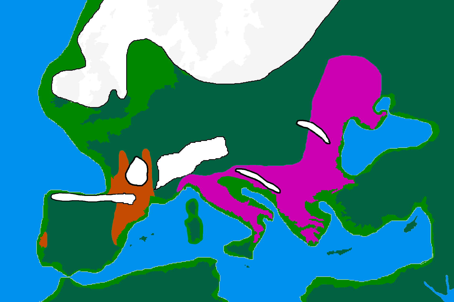
| BeskrivningEurope20000ya.png | map of Europe 20,000 years ago. |
| Datum | |
| Källa |
made by me from Image:BlankMap-Europe-v3.png, which is GFDL v1.2, outline of ancient coast and extent of ice added by me from information from "After the Ice: A Global History" by Steve Mithen. Information about human refugia from "Origins of the British" by Stephen Oppenheimer and "Out of Eden by Stephen Oppenheimer. These were sketched in by me from information supplied by these books. Coloured areas are the furthest extent of the cultures between 15 kya and 20 kya. |
| Skapare | User:Wobble |
| Tillstånd (Återanvändning av denna fil) |
GFDL |
Licensiering

|
Tillstånd ges att kopiera, distribuera och/eller modifiera detta dokument under villkoren i GNU Free Documentation License, Version 1.2 eller senare version publicerad av Free Software Foundation, utan oföränderliga avsnitt, framsidestexter eller baksidestexter. En kopia av licensen ingår i avsnittet GNU Free Documentation License.http://www.gnu.org/copyleft/fdl.htmlGFDLGNU Free Documentation Licensetruetrue |
| Denna fil har gjorts tillgänglig under licensen Creative Commons Erkännande-Dela Lika 3.0 Unported | ||
| ||
| Detta licenstillägg lades till till denna fil som en del av GFDL:s licensuppdatering.http://creativecommons.org/licenses/by-sa/3.0/CC BY-SA 3.0Creative Commons Attribution-Share Alike 3.0truetrue |
Bildtexter
Ingen bildtext har definierats
Objekt som porträtteras i den här filen
motiv
25 februari 2007
image/png
Filhistorik
Klicka på ett datum/klockslag för att se filen som den såg ut då.
| Datum/Tid | Miniatyrbild | Dimensioner | Användare | Kommentar | |
|---|---|---|---|---|---|
| nuvarande | 12 april 2007 kl. 18.00 | | 1 900 × 1 264 (98 kbyte) | Wobble | Reverted to earlier revision |
| 12 april 2007 kl. 17.59 |  | 1 000 × 665 (106 kbyte) | Wobble | Reverted to earlier revision | |
| 12 april 2007 kl. 17.50 |  | 1 900 × 1 264 (98 kbyte) | Wobble | better version, shows refugia better, from Oppenheimer, Out of Eden | |
| 28 mars 2007 kl. 10.13 |  | 1 000 × 665 (106 kbyte) | Dbachmann | shrunk; accounting for Black Sea flood. | |
| 25 februari 2007 kl. 20.59 |  | 1 900 × 1 264 (129 kbyte) | Wobble | {{Information |Description=map of Europe 20,000 years ago. |Source=made from Image:BlankMap-Europe-v3.png, which is GFDL v1.2 by me, outline of coast and extent of ice added by me from information from "After the Ice: A GLoba History" by Steve Mithen. |
Filanvändning
Följande 2 sidor använder den här filen:
Global filanvändning
Följande andra wikier använder denna fil:
- Användande på ar.wikipedia.org
- Användande på bs.wikipedia.org
- Användande på ca.wikipedia.org
- Användande på cs.wikipedia.org
- Användande på de.wikipedia.org
- Användande på en.wikipedia.org
- Europe
- River Thames
- Upper Paleolithic
- Last Glacial Maximum
- Refugium (population biology)
- User:Swid/Sandbox
- Haplogroup I-M170
- Genetic history of Europe
- Last Glacial Maximum refugia
- User:Hans Adler/Sandbox
- User:Wobble/images
- Cro-Magnon
- Epigravettian
- User:Bongan/genetic history of the human race
- Western Hunter-Gatherer
- User:Baum019/Last Glacial Maximum refugia
- Användande på en.wikiversity.org
- Användande på eo.wikipedia.org
- Användande på es.wikipedia.org
- Användande på eu.wikipedia.org
- Användande på fa.wikipedia.org
- Användande på fi.wikipedia.org
- Användande på fr.wikipedia.org
Visa mer globalt användande av denna fil.
Hämtad från ”https://sv.wikipedia.org/wiki/Fil:Europe20000ya.png”