ไฟล์:Cryosphere_Fuller_Projection.png
From Wikipedia, the free encyclopedia
ดูภาพที่มีความละเอียดสูงกว่า (2,703 × 1,079 พิกเซล, ขนาดไฟล์: 1.03 เมกะไบต์, ชนิดไมม์: image/png)
| รูปภาพหรือไฟล์เสียงนี้ ต้นฉบับอยู่ที่ คอมมอนส์ รายละเอียดด้านล่าง เป็นข้อความที่แสดงผลจาก ไฟล์ต้นฉบับในคอมมอนส์
|
ความย่อ
| คำอธิบายCryosphere Fuller Projection.png |
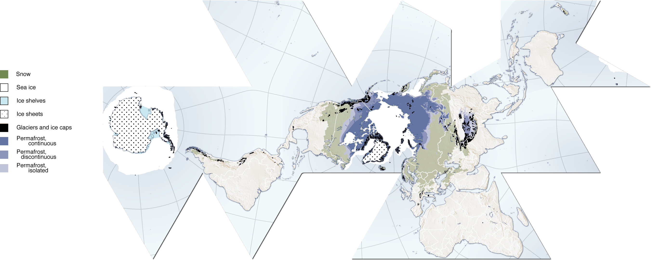
(Cryosphere) English: Author, Hugo Ahlenius, UNEP/GRID-Arendal. Full graphic, including sources, referencing etc are available here: http://maps.grida.no/go/graphic/cryosphere
.Image donated by author, no restrictions on use. Notes: Snow cover extent for Northern Hemisphere is represented by the 1966-2005 February average, for Southern Hemisphere by the 1987-2003 August average. Sea ice extent for Northern Hemisphere is represented by the 1979-2003 March average, for Southern Hemisphere by the 1979-2002 September average. Permafrost data for mountain areas and for the Southern Hemisphere are not represented in this map, neither are river and lake ice. Data sources: Armstrong, R.L. and Brodzik, M.J. (2005). Northern Hemisphere EASE-Grid weekly snow cover and sea ice extent version 3. (Digital media). National Snow and Ice Data Center, Boulder Armstrong, R.L., Brodzik, M.J., Knowles, K. and Savoie, M. (2005). Global monthly EASE-Grid snow water equivalent climatology. (Digital media). National Snow and Ice Data Center, Boulder Brown, J., Ferrians Jr., O.J., Heginbottom, J.A. and Melnikov, E.S. (1998 revised February 2001). Circum-Arctic map of permafrost and ground-ice conditions. (Digital media). National Snow and Ice Data Center/World Data Center for Glaciology, Boulder NGA (2000). Vector Map Level 0. National Geospatial-Intelligence Agency. http://geoengine.nima.mil/ftpdir/archive/vpf_ data/v0soa.tar.gz [Accessed 1 September 2006] Stroeve, J. and Meier, W. (1999, updated 2005). Sea Ice Trends and Climatologies from SMMR and SSM/I. National Snow and Ice Data Center. http://nsidc.org/data/smmr_ssmi_ ancillary/monthly_means.html [Accessed 20 April 2007] |
| วันที่ | 12 มิถุนายน พ.ศ. 2550 (original upload date) |
| แหล่งที่มา |
http://www.grida.no/graphicslib/detail/the-cryosphere-world-map_e290 นำเข้าจาก en.wikipedia มายังคอมมอนส์ โดย Pixeltoo โดยใช้ CommonsHelper |
| ผู้สร้างสรรค์ | Fraxen ที่ วิกิพีเดียภาษาอังกฤษ |
การอนุญาตใช้สิทธิ

|
อนุญาตให้คัดลอก แจกจ่ายและ/หรือดัดแปรเอกสารนี้ภายใต้เงื่อนไขของสัญญาอนุญาตเอกสารเสรีของกนู รุ่น 1.2 หรือรุ่นใด ๆ นับจากนี้ที่ออกโดยมูลนิธิซอฟต์แวร์เสรี โดยไม่มีส่วนใดห้ามแก้ไข ไม่มีข้อความปกหน้าและปกหลัง สำเนาของสัญญาอนุญาตรวมอยู่ในส่วนชื่อ สัญญาอนุญาตเอกสารเสรีของกนูhttp://www.gnu.org/copyleft/fdl.htmlGFDLGNU Free Documentation Licensetruetrue |
| ไฟล์นี้อยู่ภายใต้สัญญาอนุญาต ครีเอทีฟคอมมอนส์ แบบแสดงที่มา-อนุญาตแบบเดียวกัน 3.0 ต้นฉบับ | ||
| การแสดงที่มา: Fraxen ที่ วิกิพีเดียภาษาอังกฤษ | ||
| ||
| ป้ายแสดงสถานะลิขสิทธิ์นี้ถูกเพิ่มเพื่อให้เป็นไปตามการเปลี่ยนแปลงสัญญาอนุญาตของมูลนิธิวิกิมีเดีย จาก GFDL ไปยัง GFDL ควบคู่กับ CC-BY-SA 3.0http://creativecommons.org/licenses/by-sa/3.0/CC BY-SA 3.0Creative Commons Attribution-Share Alike 3.0truetrue |
- คุณสามารถ:
- ที่จะแบ่งปัน – ที่จะทำสำเนา แจกจ่าย และส่งงานดังกล่าวต่อไป
- ที่จะเรียบเรียงใหม่ – ที่จะดัดแปลงงานดังกล่าว
- ภายใต้เงื่อนไขต่อไปนี้:
- แสดงที่มา – คุณต้องให้เกียรติเจ้าของงานอย่างเหมาะสม โดยเพิ่มลิงก์ไปยังสัญญาอนุญาต และระบุหากมีการเปลี่ยนแปลง คุณอาจทำเช่นนี้ได้ในรูปแบบใดก็ได้ตามควร แต่ต้องไม่ใช่ในลักษณะที่แนะว่าผู้ให้อนุญาตสนับสนุนคุณหรือการใช้งานของคุณ
- อนุญาตแบบเดียวกัน – หากคุณดัดแปลง เปลี่ยนรูป หรือต่อเติมงานนี้ คุณต้องใช้สัญญาอนุญาตแบบเดียวกันหรือแบบที่เหมือนกับสัญญาอนุญาตที่ใช้กับงานนี้เท่านั้น
ปูมการอัปโหลดต้นฉบับ
- 2007-06-12 08:06 Fraxen 2703×1079× (1080674 bytes)
- 2007-06-12 08:04 Fraxen 500×200× (73656 bytes)
- 2007-06-12 08:00 Fraxen 2703×1079× (1080674 bytes) Author, Hugo Ahlenius, UNEP/GRID-Arendal. Full graphic, including sources, referencing etc are available here: http://maps.grida.no/go/graphic/cryosphere Image donated by author, no restrictions on use. Notes: Snow cover extent for Northern Hemisphere is
คำบรรยายโดยย่อ
ไอเทมที่แสดงอยู่ในไฟล์นี้
ประกอบด้วย
12 มิถุนายน 2007
media type อังกฤษ
image/png
checksum อังกฤษ
7be9b55074ffbbb08dc7843d16b86e2bc818f6aa
data size อังกฤษ
1,075,432 ไบต์
1,079 พิกเซล
2,703 พิกเซล
ประวัติไฟล์
คลิกวันที่/เวลาเพื่อดูไฟล์ที่ปรากฏในขณะนั้น
| วันที่/เวลา | รูปย่อ | ขนาด | ผู้ใช้ | ความเห็น | |
|---|---|---|---|---|---|
| ปัจจุบัน | 23:48, 3 ธันวาคม 2557 | 2,703 × 1,079 (1.03 เมกะไบต์) | Gabrielsanz | Added the areas of glaciers and ice sheet in Sierra Nevada de Mérida (see Pico Bolívar, Pico Humboldt and [[Category:Glaciers of Venezuela|Glacier... | |
| 22:57, 3 ธันวาคม 2557 | 2,703 × 1,079 (1.03 เมกะไบต์) | Gabrielsanz | Added the area of glaciers and ice cap located in Sierra Nevada de Mérida (see Pico Bolívar and Pico Humboldt) | ||
| 17:56, 23 พฤศจิกายน 2551 | 2,703 × 1,079 (1.03 เมกะไบต์) | File Upload Bot (Magnus Manske) | {{BotMoveToCommons|en.wikipedia}} {{Information |Description={{en|Author, Hugo Ahlenius, UNEP/GRID-Arendal. Full graphic, including sources, referencing etc are available here: http://maps.grida.no/go/graphic/cryosphere Image donated by author, no restri |
หน้าที่มีภาพนี้
หน้าต่อไปนี้ โยงมาที่ภาพนี้:
การใช้ไฟล์ข้ามโครงการ
วิกิอื่นต่อไปนี้ใช้ไฟล์นี้:
- การใช้บน ar.wikipedia.org
- การใช้บน ast.wikipedia.org
- การใช้บน az.wikipedia.org
- การใช้บน ca.wikipedia.org
- การใช้บน el.wikipedia.org
- การใช้บน en.wikipedia.org
- การใช้บน en.wikiversity.org
- User:Marshallsumter/Rocks/Glaciers/Astroglaciology
- User:Marshallsumter/Rocks/Glaciers/Astroglaciology/Quiz
- Callisto/Quiz
- User:Marshallsumter/Rocks/Ice sheets/Europa/Quiz
- User:Marshallsumter/Rocks/Rocky objects/Ganymede/Quiz
- Stars/Solar systems/Quiz
- User:Marshallsumter/Rocks/Rocky objects/Earth
- Minerals/Ices/Brittle ices/Quiz
- User:Marshallsumter/Rocks/Glaciers/Quiz
- User:Marshallsumter/Rocks/Glaciers/Glaciology/Quiz
- User:Marshallsumter/Rocks/Ice sheets/Enceladus/Quiz
- Minerals/Ices/Black ices/Quiz
- Ice sheets/Quiz
- User:Marshallsumter/Radiation astronomy/Earth
- การใช้บน es.wikipedia.org
- การใช้บน et.wikipedia.org
- การใช้บน eu.wikipedia.org
- การใช้บน fa.wikipedia.org
- การใช้บน fr.wikipedia.org
- การใช้บน id.wikipedia.org
- การใช้บน it.wikipedia.org
- การใช้บน ja.wikipedia.org
- การใช้บน ka.wikipedia.org
- การใช้บน la.wikipedia.org
- การใช้บน nn.wikipedia.org
- การใช้บน om.wikipedia.org
- การใช้บน ro.wikipedia.org
- การใช้บน si.wikipedia.org
- การใช้บน sr.wikipedia.org
- การใช้บน tr.wikipedia.org
- การใช้บน uk.wikipedia.org
- การใช้บน ur.wikipedia.org
- การใช้บน vi.wikipedia.org
- การใช้บน zh.wikipedia.org
- การใช้บน zu.wikipedia.org
ข้อมูลเกี่ยวกับภาพ
ภาพนี้มีข้อมูลเพิ่มเติม ซึ่งส่วนใหญ่มาจากกล้องดิจิตอลหรือสแกนเนอร์ที่สามารถเก็บข้อมูลดังกล่าวไว้รวมกับภาพได้ ถ้าภาพนี้ถูกปรับปรุงแก้ไขหรือเปลี่ยนแปลงจากเดิม ข้อมูลบางอย่างจะยังคงไม่เปลี่ยนแปลงเหมือนภาพที่ถูกปรับปรุงแก้ไขนั้น
| ความละเอียดแนวนอน | 28.35 dpc |
|---|---|
| ความละเอียดแนวตั้ง | 28.35 dpc |