Faýl:AYool_topography_15min.png
From Wikipedia, the free encyclopedia
Bu synlawyň ölçegi: 800 × 561 piksel. Other resolutions: 320 × 224 piksel | 640 × 448 piksel | 1 024 × 717 piksel | 1 280 × 897 piksel | 1 617 × 1 133 piksel.
Original faýl (1 617 × 1 133 piksel, faýlyň ölçegi: 1,15 MB, MIME tipli: image/png)
Bu faýl Wikimedia Commons toplaýjysyndan, özem başga taslamalarda ulanylýan bolmagy mümkin. Onuň faýl düşündiriş sahypasyndaky maglumatlar aşakda görkezilýär.
Gysgaça düşündiriş
| DüşündirişAYool topography 15min.png |
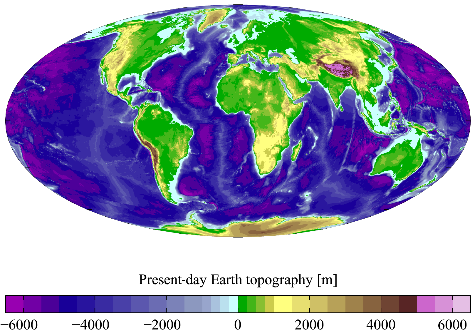
English: Present-day Earth topography and bathymetry at 15-minute horizontal resolution. Derived from the National Geophysical Data Center's TerrainBase Digital Terrain Model (v1.0). The original dataset is at 5-minute resolution, and this has been averaged down to 15-minute resolution. It is plotted here using a Mollweide projection (using MATLAB and the M_Map package). |
| Sene | |
| Çeşme | English Wikipedia |
| Awtor | Plumbago |
| Beýleki wersiýalar |
Derivative works of this file: |
Lisenzirleme
I, the copyright holder of this work, hereby publish it under the following licenses:

|
Permission is granted to copy, distribute and/or modify this document under the terms of the GNU Free Documentation License, Version 1.2 or any later version published by the Free Software Foundation; with no Invariant Sections, no Front-Cover Texts, and no Back-Cover Texts. A copy of the license is included in the section entitled GNU Free Documentation License.http://www.gnu.org/copyleft/fdl.htmlGFDLGNU Free Documentation Licensetruetrue |
| Bu faýl Creative Commons Attribution-Share Alike 3.0 Unported lisenziýasyna laýyklykda lisenzirlenendir. | ||
| ||
| This licensing tag was added to this file as part of the GFDL licensing update.http://creativecommons.org/licenses/by-sa/3.0/CC BY-SA 3.0Creative Commons Attribution-Share Alike 3.0truetrue |
Bu faýl Creative Commons Attribution 2.5 Generic lisenziýasyna laýyklykda lisenzirlenendir.
- Siz erkin:
- paýlaşyň – iş göçüriň, paýlaň we gowşuryň
- goşuşdyryp dörediň – iş adaptirläň
- Aşakdaky şertlere laýyklykda:
- salgylanma – Esere awtor ýa-da lisenziýa eýesi tarapyndan görkezilen (ýöne sizi ýa-da eseri ulanmaklygyňyzy goldaýandyklaryny öňe sürmeýän) görnüşde salgylanmalydyr.
Islän lisenziýaňyzy saýlap bilersiňiz.
Captions
Add a one-line explanation of what this file represents
Summer Earth 2023 Log
Items portrayed in this file
depicts iňlis dili
copyright status iňlis dili
copyrighted iňlis dili
copyright license iňlis dili
inception iňlis dili
7 mart 2007
media type iňlis dili
image/png
checksum iňlis dili
713475ce2ce7f77875407450fddbcb7f68925a1a
data size iňlis dili
1207885 byte
height iňlis dili
1133 pixel
width iňlis dili
1617 pixel
Faýlyň taryhy
Faýlyň geçmişini görmek üçin Sene/Wagt bölümündäki senelere tyklaň.
| Sene/Wagt | Miniatýura | Ölçegler | Ulanyjy | Teswir | |
|---|---|---|---|---|---|
| häzirki | 18:18, 10 noýabr 2011 | | 1 617 × 1 133 (1,15 MB) | JorisvS | added missing hyphen |
| 02:52, 27 ýanwar 2008 |  | 1 617 × 1 133 (1,05 MB) | Sswelm | == Summary == Present day Earth altimetry and bathymetry at 15 minute horizontal resolution. Derived from the National Geophysical Data Center's [http://www.ngdc.noaa.gov/seg/fliers/se-1104.shtml TerrainBase Digi |
Faýlyň ulanylyşy
Bu faýla çykgydy bar bolan sahypa:
Global faýl ulanyşy
Bu faýl aşakdaky beýleki wikiler tarapyndan ulanylýar:
- an.wikipedia.org sahypasynda ulanyş
- ast.wikipedia.org sahypasynda ulanyş
- ba.wikipedia.org sahypasynda ulanyş
- be.wikipedia.org sahypasynda ulanyş
- bg.wikipedia.org sahypasynda ulanyş
- bh.wikipedia.org sahypasynda ulanyş
- bn.wikipedia.org sahypasynda ulanyş
- bo.wikipedia.org sahypasynda ulanyş
- bs.wikipedia.org sahypasynda ulanyş
- ca.wikipedia.org sahypasynda ulanyş
- ceb.wikipedia.org sahypasynda ulanyş
- crh.wikipedia.org sahypasynda ulanyş
- cs.wikipedia.org sahypasynda ulanyş
- da.wikipedia.org sahypasynda ulanyş
- el.wikipedia.org sahypasynda ulanyş
- en.wikipedia.org sahypasynda ulanyş
- Earth
- Physical oceanography
- Bathymetric chart
- Terrain
- Bathymetry
- User:Plumbago/Images
- Geology of solar terrestrial planets
- User:Plumbago/Science
- User:Mitternacht90/EarthandSpace
- Talk:Continent/Archive 5
- User:AvionArchon/sandbox
- User:Darth Tacker/TWA/Earth
- User:CheChe/Spoken Script
- User:Zanygenius/TWA/Earth
- User:Zanygenius/TWA/Earth/2
- User:GeoVenturing/FOCCPAC
- User:Google7722/TWA/Earth
- User:Xultsch
- Portal:World
- User:FreshYoMama/TWA/Earth
- User:FreshYoMama/TWA/Earth/2
- en.wikiversity.org sahypasynda ulanyş
- es.wikipedia.org sahypasynda ulanyş
- eu.wikipedia.org sahypasynda ulanyş
- fa.wikipedia.org sahypasynda ulanyş
Bu faýlyň global ulanyşyny görkez.
Meta-maglumat
Bu faýlda, ähtimal, dijital fotoapparat ýa-da skaner tarapyndan goşulan goşmaça maglumatlar bardyr. Eger faýl soňradan redaktirlenen bolsa, onda käbir maglumatlar häzirki redaktirlenen faýly görä köneligine galan bolup biler.
| Kese ölçeg | 37,79 dpc |
|---|---|
| Dik ölçeg | 37,79 dpc |
| Faýl özgerdiş senesi we wagty | 10:08, 7 mart 2007 |