File:East-Hem_323bc.jpg
З Вікіпедії, безкоштовно encyclopedia
Повна роздільність (3240 × 1903 пікселів, розмір файлу: 712 КБ, MIME-тип: image/jpeg)
| Відомості про цей файл містяться на Вікісховищі — централізованому сховищі вільних файлів мультимедіа для використання у проектах Фонду Вікімедіа. |

|
Це зображення невідомого типу «historical map» має бути конвертоване у векторний формат SVG. Це дає декілька переваг, докладніше про які Ви можете прочитати на сторінці Commons:Media for cleanup. Якщо Вам вже зараз доступна векторна версія даного зображення, завантажте її, будь ласка. Після завантаження замініть цей шаблон на такий: {{vector version available|Назва_завантаженого_файлу.svg}}.
|
 | Цей файл був завантажений у форматі JPEG, навіть не зважаючи на те, що він складається з не фотографічних даних. Ця інформація може бути збережена ефективніше або точніше у форматі PNG або форматі SVG. Якщо можливо, будь ласка, завантажте PNG або SVG версію цього зображення без артефактів стиснення, що походить з не-JPEG джерела (або із видаленням наявних артефактів). Після цього, будь ласка, позначте JPEG версію наступним чином {{Superseded|Нове зображення.ext}} та вилучіть цю мітку. Ця мітка не повинна застосовуватись до фотографій та сканів. Задля подробиць, див. {{BadJPEG}}. |  |
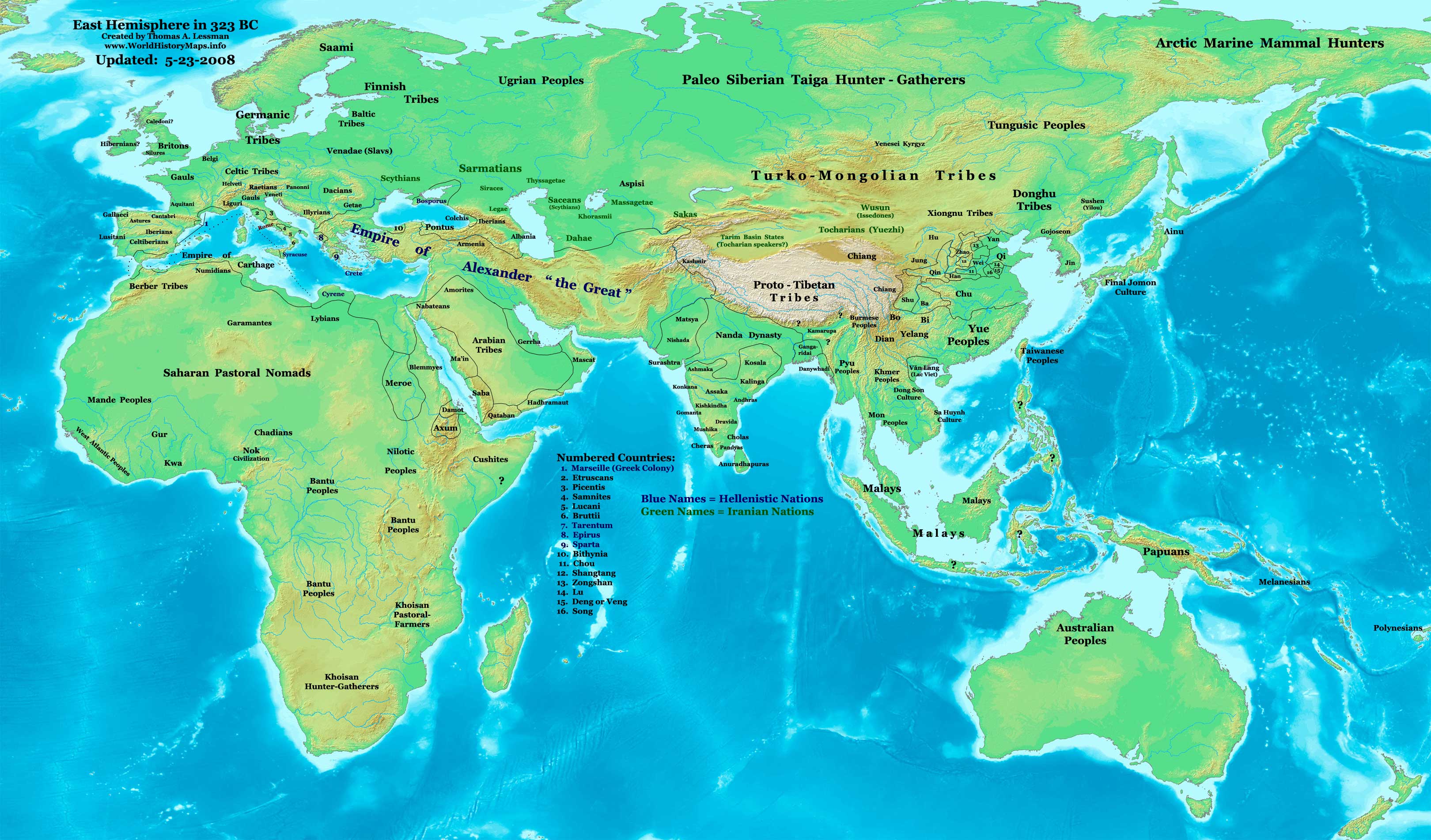
| ОписEast-Hem 323bc.jpg |
English: Eastern Hemisphere in 323 BC, at the death of Alexander the Great. |
| Джерело | Власна робота (For reference information, see below) |
| Автор | Thomas Lessman (Contact!) |
| Ліцензія (Повторне використання цього файлу) |
Я, власник авторських прав на цей твір, добровільно публікую його на умовах такої ліцензії: Цей файл ліцензований на умовах ліцензії Creative Commons Attribution-Share Alike 3.0 Unported
|
Зміст
Map Summary
Original Source URL: http://www.thomaslessman.com/History/images/East-Hem_323bc.jpg.
This map of the Eastern Hemisphere in 323 BC was created by Thomas Lessman, based on information from the sources listed below. This map is free for educational use (see Permission info above). When using this map, please mention that it is available for free at www.WorldHistoryMaps.info.
Map Source References
- Remember, sources often conflict with each other. This map is only as accurate as the information that is available to me.
- To report any errors or to help further this work, please use the Corrections page, or email Thomas Lessman at talessman@yis.us
References for information contained in this map:
Empire of Alexander the Great information is derived from:
- The DK Atlas of World History, 2000 Edition; map of Alexander's Empire and successors; (Pg. 224)
- Wikimedia's map of The Empire of Alexander the Great uploaded by User talk:Captain Blood
- Wikipedia's article about Alexander the Great
I - European Information:
- Roman Republic borders are derived from The DK Atlas of World History, 2000 Edition; Pg. 178; Map of Italy in 240 BCE (also shows Roman borders in 300 BCE).
II - Asian Information:
- Chinese Area borders are derived from this map of The Contending States Boundries c. 350 BC, available on Huhai.net.
- Indian Kingdoms locations are derived from Wikimedia's map of Epic India.
- Gangaridai Note: the borders depicted for Gangaridai are not shown on any maps I've seen, they are described rather vaguely in the sources below:
- This article about The Origins of the Ganga Dynasty - A New Insight archive copy at the Wayback Machine by Dr. Harihar Kanungo; (Pg 25, section a).
- This article from Missouri Southern State University about Gangaridae in Megasthenes' Indica archive copy at the Wayback Machine; (Section 37).
- The History of Bengal website, which contains extensive information on an archeological site called Chandraketugarh, which may be the lost city of Ganga (the capital of Gangaridai).
- Nanda Dynasty borders are derived from:
- The DK Atlas of World History, 2000 Edition; Map of The Nanda and Mauryan Empires 365-181 BCE; (Pg. 241)
- Văn Lang borders are derived from:
- Wikimedia's map of Van Lang, created by User:Briangotts.
- Wikipedia's articles about Văn Lang and the Hồng Bàng Dynasty.
III - African Information and info for fringe areas like Africa, Australia, Siberia, etc. derive from:
- The DK Atlas of World History, 2000 Edition; map of The development of complex societies in Africa; (Page 160)
- Wikimedia's map of the World 323 BCE, created by User:Briangotts, and
- Wikimedia's map of the World in 300 BCE, created by User:Javierfv1212.
Note: Much of the information in this map was cross-checked with Bruce Gordon's Regnal Chronologies.
Other Maps by Thomas Lessman
| Maps of the eastern hemisphere showing history
Bold dates are available on Wikimedia or Wikipedia. | ||
| Primeval | ||
| Ancient
|
·| 600 BC | 550 BC | 527 BC | 500 BC |
400 BC | ·| 1 AD | 50 AD | 100 AD | 200 AD | 300 AD | | |
| Medieval |
·| 500 AD | 565 AD | 600 AD | 700 AD | | |
| Modern |
·| 1500 AD | · * For historical maps of the whole world, | |
| history links talk edit view | ||
Журнал завантажень локального файлу
- 2007-12-21 15:09 Talessman 3240×1903×8 (717376 bytes) Corrected info for Far eastern peoples, more info for Africa and Europe
- 2007-11-21 19:34 Talessman 3240×1903×8 (697847 bytes) Added info on lesser-known cultures. Also changed text color of Helenistic states to Blue, of Iranian peoples to green, and added names of smaller nations (numbered legend).
- 2007-11-06 22:20 Talessman 3240×1903×8 (689151 bytes) Corrected borders in Sudan (Meroe) and Arabia, added info for Japan, Indonesia, etc.
- 2007-10-02 17:49 Talessman 2880×1692×8 (546378 bytes) Author: Thomas A. Lessman. Source URL: http://www.ThomasLessman.com/History/images/East-Hem_323bc.jpg. Image was created by me (Thomas Lessman) based on historical information located on Wikipedia, as well as information from maps located in Wikipedia and
- 2007-09-12 21:35 Talessman 2880×1692×8 (514268 bytes) Author: Thomas A. Lessman. Source URL: http://www.ThomasLessman.com/History/images/East-Hem_323bc.jpg. Image was created by me (Thomas Lessman) based on historical information located on Wikipedia, as well as information from maps located in Wikipedia and
Підписи
Об'єкти, показані на цьому файлі
зображує
Якесь значення без елемента на сайті Вікідані
image/jpeg
Історія файлу
Клацніть на дату/час, щоб переглянути, як тоді виглядав файл.
| Дата/час | Мініатюра | Розмір об'єкта | Користувач | Коментар | |
|---|---|---|---|---|---|
| поточний | 15:08, 26 лютого 2011 | | 3240 × 1903 (712 КБ) | Martin H. | Reverted to version as of 07:37, 23 May 2008, downscaling |
| 11:59, 24 лютого 2011 |  | 800 × 470 (86 КБ) | Prince of Nothing05 | Armenia wasn't part of Alexander the Greta's Empire | |
| 07:37, 23 травня 2008 |  | 3240 × 1903 (712 КБ) | Talessman | Corrected borders of Rome, Carthage, Alexander's Empire, Nanda Empire, and China. Also corrected placement of Tocharians, added more info for Europe, India, Africa, and East Asia. | |
| 14:53, 9 травня 2008 |  | 3240 × 1903 (708 КБ) | Talessman | {{Information |Description='''Eastern Hemisphere in 500 BC'''. |Source=self-made (For reference information, see below) |Author=Thomas Lessman (Contact!) |Permission={{self|cc-by-sa-3.0}} }} |
Використання файлу
Нема сторінок, що використовують цей файл.
Глобальне використання файлу
Цей файл використовують такі інші вікі:
- Використання в ar.wikipedia.org
- Використання в azb.wikipedia.org
- Використання в de.wikipedia.org
- Використання в el.wikipedia.org
- Використання в en.wikipedia.org
- Використання в en.wikibooks.org
- Використання в es.wikipedia.org
- Використання в fa.wikipedia.org
- Використання в it.wikipedia.org
- Використання в lv.wikipedia.org
- Використання в mk.wikipedia.org
- Використання в ru.wikipedia.org
- Використання в sh.wikipedia.org
- Використання в sl.wikipedia.org
- Використання в sq.wikipedia.org
- Використання в su.wikipedia.org
- Використання в ta.wikipedia.org
- Використання в vi.wikipedia.org
- Використання в zh.wikibooks.org