Tập_tin:Peloponnesos_Map.png
From Wikipedia, the free encyclopedia
Tập tin gốc (808×852 điểm ảnh, kích thước tập tin: 234 kB, kiểu MIME: image/png)
Tập tin này từ Wikimedia Commons. Trang miêu tả nó ở đấy được sao chép dưới đây. Commons là kho lưu trữ tập tin phương tiện có giấy phép tự do. Bạn có thể tham gia. |
| Miêu tảPeloponnesos Map.png |
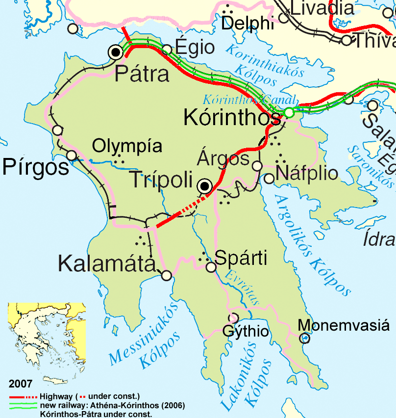
Deutsch: Wichtigste Verkehrsachsen des Peloponnes, Stand 2007.
English: Main traffic lines in the Peloponnese, as of 2007. |
| Ngày | |
| Nguồn gốc | see author |
| Tác giả | ulrichstill |
| Phiên bản khác | Adapted from http://www.un.org/Depts/Cartographic/map/profile/greece.pdf |
- Bạn được phép:
- chia sẻ – sao chép, phân phối và chuyển giao tác phẩm
- pha trộn – để chuyển thể tác phẩm
- Theo các điều kiện sau:
- ghi công – Bạn phải ghi lại tác giả và nguồn, liên kết đến giấy phép, và các thay đổi đã được thực hiện, nếu có. Bạn có thể làm các điều trên bằng bất kỳ cách hợp lý nào, miễn sao không ám chỉ rằng người cho giấy phép ủng hộ bạn hay việc sử dụng của bạn.
- chia sẻ tương tự – Nếu bạn biến tấu, biến đổi, hoặc làm tác phẩm khác dựa trên tác phẩm này, bạn chỉ được phép phân phối tác phẩm mới theo giấy phép y hệt hoặc tương thích với tác phẩm gốc.

| Public domainPublic domainfalsefalse |
| This image is a map derived from a United Nations map.
Unless stated otherwise, UN maps are to be considered in the public domain. This applies worldwide. UN maps are, in principle, open source material and you can use them in your work or for making your own map. UN requests however that you delete the UN name, logo and reference number upon any modification to the map. Content of your map will be your responsibility. You can state in your publication, if you wish, something like: based on UN map … (map name, map number, revision number and date). See: Geospatial Information Section. And: Geospatial, location data for a better world. |
 |
Chú thích
Khoản mục được tả trong tập tin này
mô tả
1 1 2008
Lịch sử tập tin
Nhấn vào ngày/giờ để xem nội dung tập tin tại thời điểm đó.
| Ngày/giờ | Hình xem trước | Kích cỡ | Thành viên | Miêu tả | |
|---|---|---|---|---|---|
| hiện tại | 17:54, ngày 16 tháng 1 năm 2008 | | 808×852 (234 kB) | Ulrichstill | {{Information| |Description= {{de|Wichtigste Verkehrsachsen des Peloponnes, Stand 2007.}} {{en|Main traffic lines in the Peloponnese, as of 2007.}} |Source= see author |Date=01.01.2008 |Author = [[:de:Benutzer:ulrich |
Trang sử dụng tập tin
Sử dụng tập tin toàn cục
Những wiki sau đang sử dụng tập tin này:
- Trang sử dụng tại als.wikipedia.org
- Trang sử dụng tại bg.wikipedia.org
- Trang sử dụng tại cy.wikipedia.org
- Trang sử dụng tại da.wikipedia.org
- Trang sử dụng tại de.wikipedia.org
- Trang sử dụng tại en.wikipedia.org
- Trang sử dụng tại et.wikipedia.org
- Trang sử dụng tại fr.wikipedia.org
- Trang sử dụng tại hr.wikipedia.org
- Trang sử dụng tại hyw.wikipedia.org
- Trang sử dụng tại id.wikipedia.org
- Trang sử dụng tại ja.wikipedia.org
- Trang sử dụng tại la.wikipedia.org
- Trang sử dụng tại lt.wikipedia.org
- Trang sử dụng tại mk.wikipedia.org
- Trang sử dụng tại ms.wikipedia.org
- Trang sử dụng tại nds.wikipedia.org
- Trang sử dụng tại oc.wikipedia.org
- Trang sử dụng tại pnb.wikipedia.org
- Trang sử dụng tại th.wikipedia.org
- Trang sử dụng tại ur.wikipedia.org
- Trang sử dụng tại zh-min-nan.wikipedia.org