File:AYool_topography_15min.png
维基百科,自由的 encyclopedia
本预览的尺寸:800 × 561像素。 其他分辨率:320 × 224像素 | 640 × 448像素 | 1,024 × 717像素 | 1,280 × 897像素 | 1,617 × 1,133像素。
原始文件 (1,617 × 1,133像素,文件大小:1.15 MB,MIME类型:image/png)
摘要
| 描述AYool topography 15min.png |
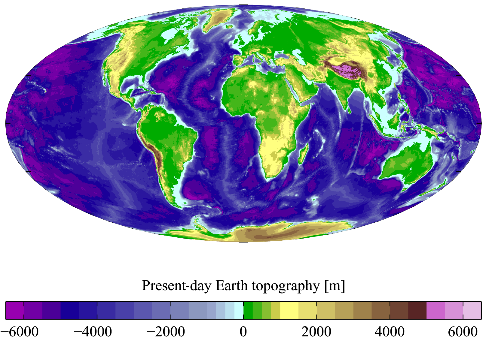
English: Present-day Earth topography and bathymetry at 15-minute horizontal resolution. Derived from the National Geophysical Data Center's TerrainBase Digital Terrain Model (v1.0). The original dataset is at 5-minute resolution, and this has been averaged down to 15-minute resolution. It is plotted here using a Mollweide projection (using MATLAB and the M_Map package). |
| 日期 | |
| 来源 | English Wikipedia |
| 作者 | Plumbago |
| 其他版本 |
Derivative works of this file: |
许可协议
我,本作品著作权人,特此采用以下许可协议发表本作品:

|
已授权您依据自由软件基金会发行的无固定段落及封面封底文字(Invariant Sections, Front-Cover Texts, and Back-Cover Texts)的GNU自由文件许可协议1.2版或任意后续版本的条款,复制、传播和/或修改本文件。该协议的副本请见“GNU Free Documentation License”。http://www.gnu.org/copyleft/fdl.htmlGFDLGNU Free Documentation Licensetruetrue |
| 本文件采用知识共享署名-相同方式共享 3.0 未本地化版本许可协议授权。 | ||
| ||
| 本许可协议标签作为GFDL许可协议更新的组成部分被添加至本文件。http://creativecommons.org/licenses/by-sa/3.0/CC BY-SA 3.0Creative Commons Attribution-Share Alike 3.0truetrue |
您可以选择您需要的许可协议。
说明
添加一行文字以描述该文件所表现的内容
Summer Earth 2023 Log
此文件中描述的项目
描绘内容
7 3 2007
image/png
数据大小 简体中文(已转写)
1,207,885 字节
1,133 像素
1,617 像素
文件历史
点击某个日期/时间查看对应时刻的文件。
| 日期/时间 | 缩略图 | 大小 | 用户 | 备注 | |
|---|---|---|---|---|---|
| 当前 | 2011年11月10日 (四) 18:18 | | 1,617 × 1,133(1.15 MB) | JorisvS | added missing hyphen |
| 2008年1月27日 (日) 02:52 |  | 1,617 × 1,133(1.05 MB) | Sswelm | == Summary == Present day Earth altimetry and bathymetry at 15 minute horizontal resolution. Derived from the National Geophysical Data Center's [http://www.ngdc.noaa.gov/seg/fliers/se-1104.shtml TerrainBase Digi |
文件用途
以下5个页面使用本文件:
全域文件用途
以下其他wiki使用此文件:
- an.wikipedia.org上的用途
- ast.wikipedia.org上的用途
- ba.wikipedia.org上的用途
- be.wikipedia.org上的用途
- bg.wikipedia.org上的用途
- bh.wikipedia.org上的用途
- bn.wikipedia.org上的用途
- bo.wikipedia.org上的用途
- bs.wikipedia.org上的用途
- ca.wikipedia.org上的用途
- ceb.wikipedia.org上的用途
- crh.wikipedia.org上的用途
- cs.wikipedia.org上的用途
- da.wikipedia.org上的用途
- el.wikipedia.org上的用途
- en.wikipedia.org上的用途
- Earth
- Physical oceanography
- Bathymetric chart
- Terrain
- Bathymetry
- User:Plumbago/Images
- Geology of solar terrestrial planets
- User:Plumbago/Science
- User:Mitternacht90/EarthandSpace
- Talk:Continent/Archive 5
- User:AvionArchon/sandbox
- User:Darth Tacker/TWA/Earth
- User:CheChe/Spoken Script
- User:Zanygenius/TWA/Earth
- User:Zanygenius/TWA/Earth/2
- User:GeoVenturing/FOCCPAC
- User:Google7722/TWA/Earth
- User:XanUltra
- Portal:World
- User:FreshYoMama/TWA/Earth
- User:FreshYoMama/TWA/Earth/2
- en.wikiversity.org上的用途
- es.wikipedia.org上的用途
- eu.wikipedia.org上的用途
- fa.wikipedia.org上的用途
查看本文件的更多全域用途。
元数据
此文件中包含有扩展的信息。这些信息可能是由数码相机或扫描仪在创建或数字化过程中所添加。
如果此文件的源文件已经被修改,一些信息在修改后的文件中将不能完全反映出来。
| 水平分辨率 | 37.79 dpc |
|---|---|
| 垂直分辨率 | 37.79 dpc |
| 文件修改日期时间 | 2007年3月7日 (三) 10:08 |