File:Island_regions_of_the_Philippines.png
维基百科,自由的 encyclopedia
没有更高的分辨率。
Island_regions_of_the_Philippines.png (300 × 450像素,文件大小:11 KB,MIME类型:image/png)
摘要
| 描述Island regions of the Philippines.png |
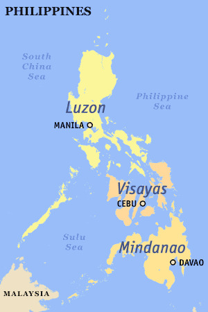
English: The island groups of the Philippines: Luzon (including Luzon proper), the Visayas, and Mindanao (including Mindanao proper).
Also labeled are the metropolitan areas. |
| 日期 | |
| 来源 |
本文件缺少来源信息。
请编辑本文件的说明并提供来源。 |
| 作者 | seav |
| 授权 (二次使用本文件) |
Released under the GFDL. |
许可协议

|
已授权您依据自由软件基金会发行的无固定段落及封面封底文字(Invariant Sections, Front-Cover Texts, and Back-Cover Texts)的GNU自由文件许可协议1.2版或任意后续版本的条款,复制、传播和/或修改本文件。该协议的副本请见“GNU Free Documentation License”。http://www.gnu.org/copyleft/fdl.htmlGFDLGNU Free Documentation Licensetruetrue |
| 本文件采用知识共享署名-相同方式共享 3.0 未本地化版本许可协议授权。 | ||
| 署名: seav | ||
| ||
| 本许可协议标签作为GFDL许可协议更新的组成部分被添加至本文件。http://creativecommons.org/licenses/by-sa/3.0/CC BY-SA 3.0Creative Commons Attribution-Share Alike 3.0truetrue |
说明
添加一行文字以描述该文件所表现的内容
此文件中描述的项目
描绘内容
文件历史
点击某个日期/时间查看对应时刻的文件。
| 日期/时间 | 缩略图 | 大小 | 用户 | 备注 | |
|---|---|---|---|---|---|
| 当前 | 2019年5月15日 (三) 11:39 | | 300 × 450(11 KB) | HueMan1 | Reverted to version as of 11:37, 5 November 2005 (UTC) |
| 2019年5月15日 (三) 11:31 |  | 300 × 450(21 KB) | HueMan1 | Reverted to version as of 09:34, 24 July 2011 (UTC) | |
| 2018年5月23日 (三) 00:39 |  | 300 × 450(33 KB) | Hohum | Cartographic colours | |
| 2011年7月24日 (日) 09:34 |  | 300 × 450(21 KB) | Adikhebat | * | |
| 2011年7月24日 (日) 09:13 |  | 300 × 450(22 KB) | Adikhebat | == {{int:filedesc}} == Map of the Philippines showing Luzon, Visayas, and Mindanao. Created and copyright (2003) by seav. Released under the GFDL. == {{int:license}} == {{GFDL-user|seav|en|migration=relicense}} [[Category:Maps of i | |
| 2011年7月24日 (日) 09:12 |  | 300 × 450(22 KB) | Adikhebat | == {{int:filedesc}} == Map of the Philippines showing Luzon, Visayas, and Mindanao. Created and copyright (2003) by seav. Released under the GFDL. == {{int:license}} == {{GFDL-user|seav|en|migration=relicense}} [[Category:Maps of i | |
| 2011年6月7日 (二) 16:56 |  | 300 × 450(36 KB) | 23prootie~commonswiki | Reverting Palawan. | |
| 2009年10月15日 (四) 03:23 |  | 300 × 450(11 KB) | Brianski | Palawan is part of Visayas according to the english wikipedia entry. | |
| 2005年11月5日 (六) 11:37 |  | 300 × 450(11 KB) | Magalhães | Map of the Philippines showing Luzon, Visayas, and Mindanao. Created and copyright (2003) by seav. Released under the GNU FDL. |
文件用途
以下页面使用本文件:
全域文件用途
以下其他wiki使用此文件:
- ar.wikipedia.org上的用途
- azb.wikipedia.org上的用途
- az.wikipedia.org上的用途
- ba.wikipedia.org上的用途
- bcl.wikipedia.org上的用途
- be-tarask.wikipedia.org上的用途
- bjn.wikipedia.org上的用途
- bs.wikipedia.org上的用途
- ceb.wikipedia.org上的用途
- cs.wikipedia.org上的用途
- da.wikipedia.org上的用途
- de.wikinews.org上的用途
- el.wikipedia.org上的用途
- en.wikipedia.org上的用途
- es.wikipedia.org上的用途
- fa.wikipedia.org上的用途
- fi.wikipedia.org上的用途
- fr.wikipedia.org上的用途
- hi.wikipedia.org上的用途
- hr.wikipedia.org上的用途
- id.wikipedia.org上的用途
- ilo.wikipedia.org上的用途
- it.wikipedia.org上的用途
- ja.wikipedia.org上的用途
- ka.wikipedia.org上的用途
查看本文件的更多全域用途。