File:Bay_Bridge_collapse_2.jpg
維基百科,自由的 encyclopedia
無更高解析度可提供。
Bay_Bridge_collapse_2.jpg (341 × 276 像素,檔案大小:12 KB,MIME 類型:image/jpeg)
摘要
| 描述Bay Bridge collapse 2.jpg |
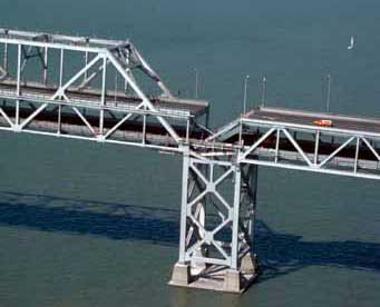
English: Aerial view of roadbed collapse near the interface of the cantil�T truss sections of the San Francisco-Oakland Bay Bridge. View northwestward. Cropped from original version to better fit en:San Francisco–Oakland Bay Bridge article. |
| 日期 | 攝於1989年10月 |
| 來源 |
USGS |
| 作者 | C.E. Meyer |
| 授權許可 (重用此檔案) |
PD-USGov-Interior-USGS |
| 其他版本 |
|


授權條款
| Public domainPublic domainfalsefalse |
|
Bahasa Indonesia ∙ català ∙ čeština ∙ Deutsch ∙ eesti ∙ English ∙ español ∙ français ∙ galego ∙ italiano ∙ Nederlands ∙ português ∙ polski ∙ sicilianu ∙ suomi ∙ Tiếng Việt ∙ Türkçe ∙ български ∙ македонски ∙ русский ∙ മലയാളം ∙ 한국어 ∙ 日本語 ∙ 中文 ∙ 中文(简体) ∙ 中文(繁體) ∙ العربية ∙ فارسی ∙ +/− |
Wikipedia upload log
A Wikipedia description page is/was here. All following user names refer to en.wikipedia.
- 2007-09-04 19:13 Paul.h 341×276×8 (12116 bytes) [http://wrgis.wr.usgs.gov/dds/dds-29/ USGS photo] from 1989 Loma Prieta earthquake. '''Caption''': Aerial view of roadbed collapse near the interface of the cantil�T truss sections of the San Francisco-Oakland Bay Bridge. View northwestward. [C.E. Meyer
說明
添加單行說明來描述出檔案所代表的內容
在此檔案描寫的項目
描繪內容
1989
image/jpeg
12,116 位元組
276 像素
341 像素
檔案歷史
點選日期/時間以檢視該時間的檔案版本。
| 日期/時間 | 縮圖 | 尺寸 | 使用者 | 備註 | |
|---|---|---|---|---|---|
| 目前 | 2008年7月6日 (日) 06:06 | | 341 × 276(12 KB) | Optigan13 | {{Information |Description={{en|Aerial view of roadbed collapse near the interface of the cantil�T truss sections of the San Francisco-Oakland Bay Bridge. View northwestward. Cropped from original version to better fit [[:en:San Francisco–Oakland Bay |
檔案用途
下列頁面有用到此檔案:
全域檔案使用狀況
以下其他 wiki 使用了這個檔案:
- en.wikipedia.org 的使用狀況
- he.wikipedia.org 的使用狀況
- pl.wikipedia.org 的使用狀況
- sl.wikipedia.org 的使用狀況
- th.wikipedia.org 的使用狀況
- tr.wikipedia.org 的使用狀況
詮釋資料
此檔案中包含其他資訊,這些資訊可能是由數位相機或掃描器在建立或數位化過程中所新增的。若檔案自原始狀態已被修改,一些詳細資料可能無法完整反映出已修改的檔案。
| _error | 0 |
|---|