File:Nuclear_plants_map_France.jpg
維基百科,自由的 encyclopedia
預覽大小:626 × 600 像素。 其他解析度:250 × 240 像素 | 501 × 480 像素 | 801 × 768 像素 | 1,200 × 1,150 像素。
原始檔案 (1,200 × 1,150 像素,檔案大小:740 KB,MIME 類型:image/jpeg)
摘要
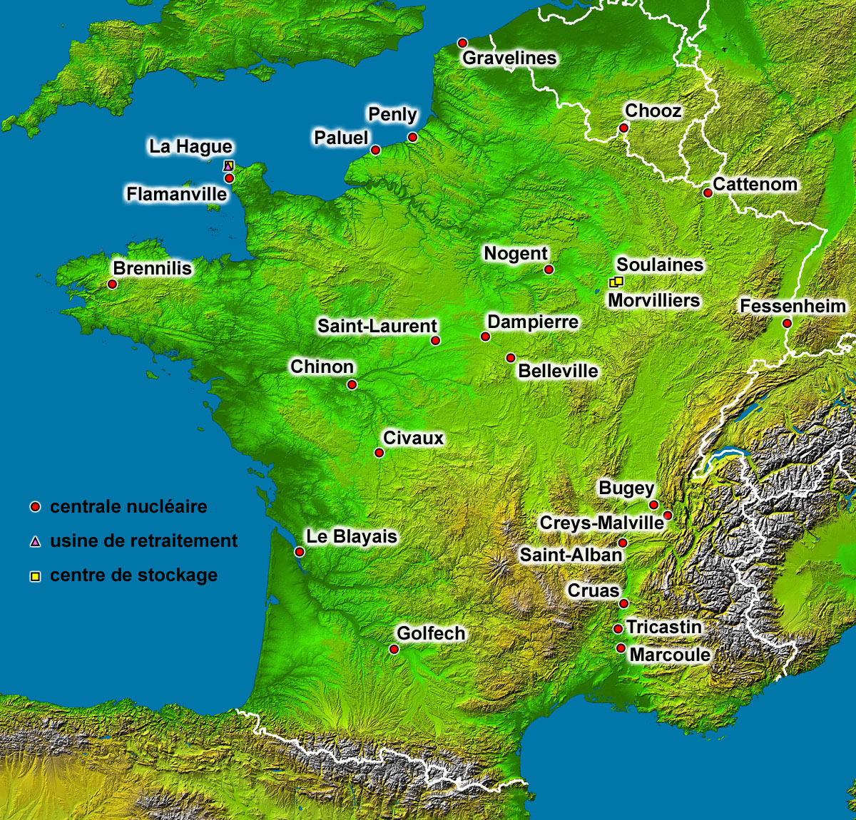
| 描述Nuclear plants map France.jpg |
English: Map of the French nuclear power plants (in French).
Français : Carte en français des centrales nucléaires, usines de retraitement et centres de stockage français. |
| 日期 | |
| 來源 | Background map : Image:France_radar_2.jpg, a modified version from the NASA Earth Observatory |
| 作者 | Eric Gaba (Sting - fr:Sting) |
| 授權許可 (重用此檔案) |
Public domain |
| 其他版本 |
|

授權條款
| Public domainPublic domainfalsefalse |
| 本作品由NASA創作,屬於公有領域。根據NASA的版權政策:“NASA的創作除非另有聲明否則不受版權保護。”(參見:Template:PD-USGov/zh,NASA版權政策或JPL圖像使用政策) | ||
 |
警告:
|
| Public domainPublic domainfalsefalse |
| This work was previously under Public Domain, or a Free License. It has been digitally enhanced and/or modified. This derivative work has been (or is hereby) released into the public domain by its author, Sting at the French Wikipedia project. This applies worldwide. 在一些國家這可能不合法;如果是這樣的話,那麼: |
說明
添加單行說明來描述出檔案所代表的內容
在此檔案描寫的項目
描繪內容
8月 2006
檔案歷史
點選日期/時間以檢視該時間的檔案版本。
| 日期/時間 | 縮圖 | 尺寸 | 使用者 | 備註 | |
|---|---|---|---|---|---|
| 目前 | 2006年9月1日 (五) 14:35 | | 1,200 × 1,150(740 KB) | Sting | Lightning effect around names enhanced |
| 2006年8月30日 (三) 05:49 |  | 1,200 × 1,150(709 KB) | Sting | {{Information |Description=Map of the French nuclear power plants (in French) |Source=Background map : Image:France_radar_2.jpg, a modified version from the [http://earthobservatory.nasa.gov/Newsroom/NewImages/images.php3?img_id=15360 NASA Earth Obse |
檔案用途
下列頁面有用到此檔案:
全域檔案使用狀況
以下其他 wiki 使用了這個檔案:
- es.wikipedia.org 的使用狀況
- fr.wikipedia.org 的使用狀況
詮釋資料
此檔案中包含其他資訊,這些資訊可能是由數位相機或掃描器在建立或數位化過程中所新增的。若檔案自原始狀態已被修改,一些詳細資料可能無法完整反映出已修改的檔案。
| 影像標題 | converted PNM file |
|---|---|
| 方位 | 標準 |
| 水平解析度 | 72 dpi |
| 垂直解析度 | 72 dpi |
| 使用軟體 | Adobe Photoshop 7.0 |
| 檔案修改日期時間 | 2006年9月1日 (五) 11:29 |
| 色彩空間 | 顏色未校準 |