File:Map_of_Taungoo_Empire_(1580).png
維基百科,自由的 encyclopedia
預覽大小:508 × 599 像素。 其他解析度:203 × 240 像素 | 407 × 480 像素 | 950 × 1,121 像素。
原始檔案 (950 × 1,121 像素,檔案大小:1.5 MB,MIME 類型:image/png)
摘要
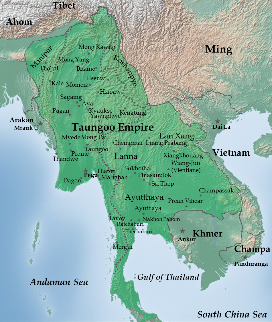
| 描述Map of Taungoo Empire (1580).png |
English: Taungoo Empire at its highest extent during the reign of King Bayinnaung (1551-1581) |
| 日期 | |
| 來源 | 自己的作品. Background map is taken from www.naturalearthdata.com (public domain: Terms of Use). |
| 作者 | Soewinhan |
References

Refer to the
- timemap from University of California, Berkeley archive copy at the Wayback Machine for the extent of Ayutthaya, Lang Xang and Lanna before Bayinnaung's conquest.
- Victor B. Lieberman (2003年) 《 Strange parallels: Southeast Asia in global context, c 800-1830, Volume 1》、pp. 152 ISBN: 0521804965. for the extent of Taungoo Empire as of 1580.
- File:Map of Toungoo Kingdom 1572.jpg and File:Map-of-southeast-asia 900 CE.png for geographic names.
- Baker, Chris. Phongpaichit, Pasuk. A History of Ayutthaya: Siam in the Early Modern World.
Notes
- The borders at that times were not demarcated. As stated in Berkeley timemap: The level of details present in some boundaries should not be interpreted as a result of a precise, detailed understanding of the borders of states during this period.
授權條款
我,本作品的著作權持有者,決定用以下授權條款發佈本作品:
此檔案採用共享創意 姓名標示-相同方式分享 3.0 未在地化版本授權條款。
- 您可以自由:
- 分享 – 複製、發佈和傳播本作品
- 重新修改 – 創作演繹作品
- 惟需遵照下列條件:
- 姓名標示 – 您必須指名出正確的製作者,和提供授權條款的連結,以及表示是否有對內容上做出變更。您可以用任何合理的方式來行動,但不得以任何方式表明授權條款是對您許可或是由您所使用。
- 相同方式分享 – 如果您利用本素材進行再混合、轉換或創作,您必須基於如同原先的相同或兼容的條款,來分布您的貢獻成品。
說明
添加單行說明來描述出檔案所代表的內容
在此檔案描寫的項目
描繪內容
21 12 2011
多媒體型式 繁體中文 (已轉換拼寫)
image/png
檔案歷史
點選日期/時間以檢視該時間的檔案版本。
| 日期/時間 | 縮圖 | 尺寸 | 用戶 | 備註 | |
|---|---|---|---|---|---|
| 目前 | 2023年7月14日 (五) 02:28 | | 950 × 1,121(1.5 MB) | Yourlocallordandsavior | Reverted to version as of 06:37, 14 February 2023 (UTC) |
| 2023年2月14日 (二) 06:42 |  | 950 × 1,121(1.66 MB) | Yourlocallordandsavior | Reverted to version as of 02:30, 12 February 2023 (UTC) | |
| 2023年2月14日 (二) 06:37 |  | 950 × 1,121(1.5 MB) | Yourlocallordandsavior | Reverted to version as of 07:39, 21 February 2013 (UTC) | |
| 2023年2月12日 (日) 02:30 |  | 950 × 1,121(1.66 MB) | Yourlocallordandsavior | Ayutthaya did not exert its influence down the peninsula in the 16th century. | |
| 2013年2月21日 (四) 07:39 |  | 950 × 1,121(1.5 MB) | Super Rad! | Cropped 1-px transparent border on left and blue border on bottom; reduced image size using PNGOUT | |
| 2011年12月22日 (四) 06:25 |  | 951 × 1,124(2.31 MB) | Soewinhan | ||
| 2011年12月20日 (二) 13:33 |  | 951 × 1,118(2.29 MB) | Soewinhan |
檔案用途
全域檔案使用狀況
以下其他 wiki 使用了這個檔案:
- ar.wikipedia.org 的使用狀況
- azb.wikipedia.org 的使用狀況
- ba.wikipedia.org 的使用狀況
- bn.wikipedia.org 的使用狀況
- ca.wikipedia.org 的使用狀況
- cs.wikipedia.org 的使用狀況
- en.wikipedia.org 的使用狀況
- es.wikipedia.org 的使用狀況
- eu.wikipedia.org 的使用狀況
- id.wikipedia.org 的使用狀況
- it.wikipedia.org 的使用狀況
- ja.wikipedia.org 的使用狀況
- km.wikipedia.org 的使用狀況
- ko.wikipedia.org 的使用狀況
- lt.wikipedia.org 的使用狀況
- mni.wikipedia.org 的使用狀況
- my.wikipedia.org 的使用狀況
- no.wikipedia.org 的使用狀況
- pa.wikipedia.org 的使用狀況
- pl.wikipedia.org 的使用狀況
- pt.wikipedia.org 的使用狀況
檢視此檔案的更多全域使用狀況。
.png)
詮釋資料
此檔案中包含擴展的資訊。這些資訊可能是由數位相機或掃描器在建立時或數位化過程中所加入。
如果此檔案的來源檔案已被修改,一些資訊在修改後的檔案中將不能完全反映出來。
| 水平解析度 | 59.05 dpc |
|---|---|
| 垂直解析度 | 59.05 dpc |
.png)