File:České_Slezsko_po_roce_1920_na_mapě_Česka.png
維基百科,自由的 encyclopedia
預覽大小:800 × 460 像素。 其他解析度:320 × 184 像素 | 640 × 368 像素 | 1,024 × 588 像素 | 1,280 × 735 像素 | 2,560 × 1,471 像素 | 3,662 × 2,104 像素。
原始檔案 (3,662 × 2,104 像素,檔案大小:346 KB,MIME 類型:image/png)
摘要
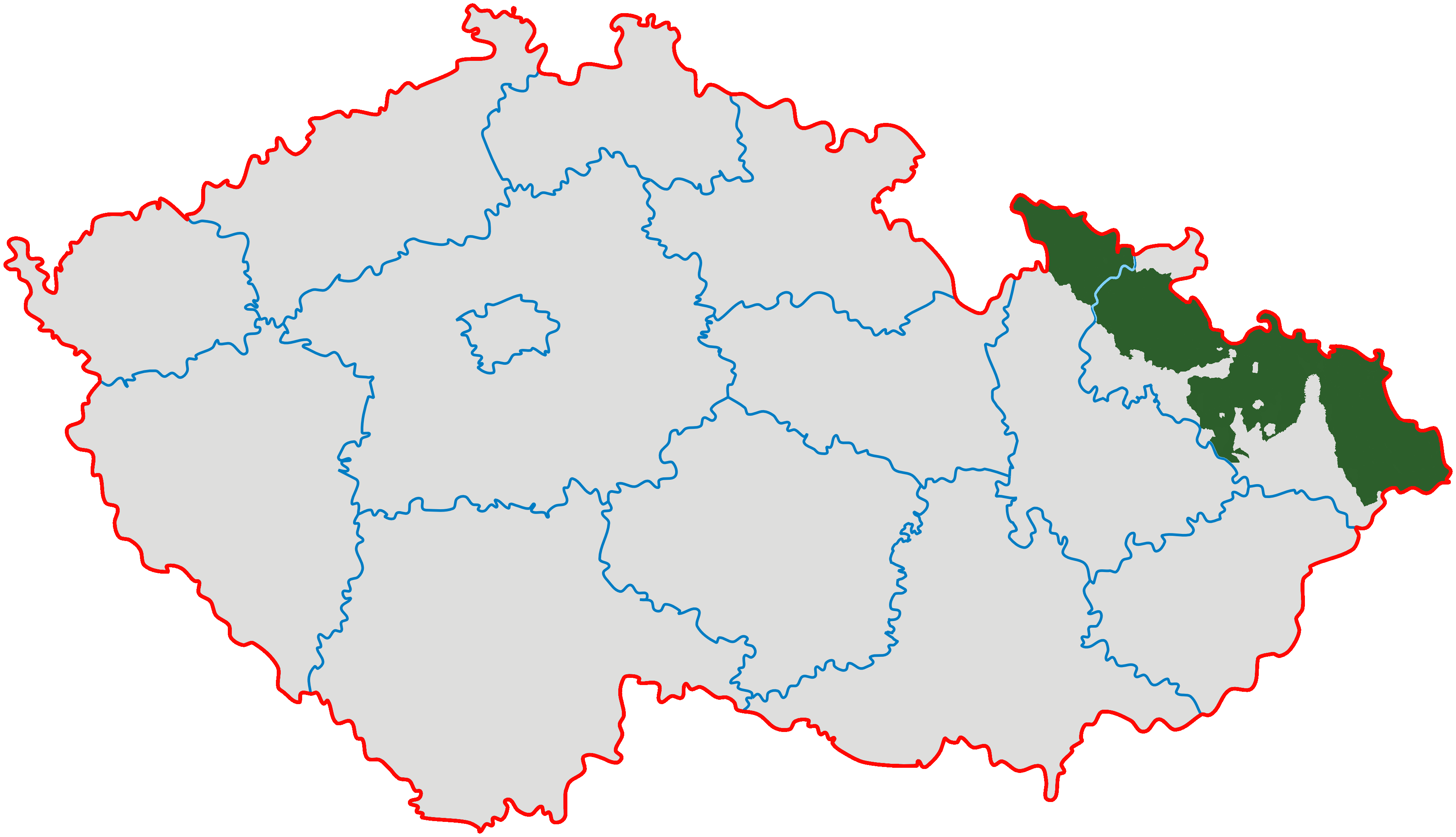
| 描述České Slezsko po roce 1920 na mapě Česka.png |
Čeština: *Zeleně je vyznačeno území vlastního Slezska v hranicích od 10. ledna 1920.
English: Czech Silesia (green); Moravian enclaves in Silesia were governed by Silesian authorities till 1928 (after creation of province of Moravia and Silesia they ceased to exist). |
| 來源 | Modified from Image:Cesko-kraje.svg |
| 作者 | Kirk |
授權條款
我,本作品的著作權持有者,決定用以下授權條款發佈本作品:
此檔案採用共享創意 姓名標示-相同方式分享 3.0 未在地化版本授權條款。
- 您可以自由:
- 分享 – 複製、發佈和傳播本作品
- 重新修改 – 創作演繹作品
- 惟需遵照下列條件:
- 姓名標示 – 您必須指名出正確的製作者,和提供授權條款的連結,以及表示是否有對內容上做出變更。您可以用任何合理的方式來行動,但不得以任何方式表明授權條款是對您許可或是由您所使用。
- 相同方式分享 – 如果您利用本素材進行再混合、轉換或創作,您必須基於如同原先的相同或兼容的條款,來分布您的貢獻成品。

|
已授權您依據自由軟體基金會發行的無固定段落、封面文字和封底文字GNU自由文件授權條款1.2版或任意後續版本,對本檔進行複製、傳播和/或修改。該協議的副本列在GNU自由文件授權條款中。http://www.gnu.org/copyleft/fdl.htmlGFDLGNU Free Documentation Licensetruetrue |
您可以選擇您需要的授權條款。
說明
添加單行說明來描述出檔案所代表的內容
在此檔案描寫的項目
描繪內容
GNU自由文檔許可證1.2或更高版本 繁體中文 (已轉換拼寫)
多媒體型式 繁體中文 (已轉換拼寫)
image/png
檔案歷史
點選日期/時間以檢視該時間的檔案版本。
| 日期/時間 | 縮圖 | 尺寸 | 用戶 | 備註 | |
|---|---|---|---|---|---|
| 目前 | 2022年1月28日 (五) 20:07 | | 3,662 × 2,104(346 KB) | Claude Zygiel | Contested status of some little areas (see discussions with GPinkerton): removed red colour |
| 2022年1月26日 (三) 05:40 |  | 3,662 × 2,104(633 KB) | GPinkerton | Reverted to version as of 22:09, 13 February 2011 (UTC) COM:CROP Incoherent | |
| 2021年12月15日 (三) 15:13 |  | 3,662 × 2,104(446 KB) | Claude Zygiel | An enclave is landlocked | |
| 2021年9月27日 (一) 03:45 |  | 3,662 × 2,104(633 KB) | GPinkerton | Reverted to version as of 22:09, 13 February 2011 (UTC) COM:CROP | |
| 2021年7月7日 (三) 16:00 |  | 3,662 × 2,104(434 KB) | Claude Zygiel | Moravian enclaves/exclaves in Silesia | |
| 2011年2月13日 (日) 22:09 |  | 3,662 × 2,104(633 KB) | Carnby | Reverted to version as of 16:44, 3 December 2009 | |
| 2011年2月13日 (日) 22:09 |  | 3,662 × 2,104(552 KB) | Carnby | Reverted to version as of 12:01, 23 September 2008 | |
| 2009年12月3日 (四) 16:44 |  | 3,662 × 2,104(633 KB) | Kirk979 | corrected map | |
| 2008年9月23日 (二) 12:01 |  | 3,662 × 2,104(552 KB) | Sevela.p | {{Information |Description= {{cs|České Slezsko po roce 1920 na mapě Česka}} |Source= *Modified from Image:Cesko-kraje.svg *Transferred from [http://cs.wikipedia.org cs.wikipedia]; transferred to Commons by User:Sevela.p using [http://tools.wi |
檔案用途
下列頁面有用到此檔案:
全域檔案使用狀況
以下其他 wiki 使用了這個檔案:
- af.wikipedia.org 的使用狀況
- bg.wikipedia.org 的使用狀況
- cs.wikipedia.org 的使用狀況
- en.wikipedia.org 的使用狀況
- eo.wikipedia.org 的使用狀況
- fi.wikipedia.org 的使用狀況
- fr.wikipedia.org 的使用狀況
- id.wikipedia.org 的使用狀況
- ja.wikipedia.org 的使用狀況
- ka.wikipedia.org 的使用狀況
- lt.wikipedia.org 的使用狀況
- lv.wikipedia.org 的使用狀況
- nl.wikipedia.org 的使用狀況
- pl.wikipedia.org 的使用狀況
- pnb.wikipedia.org 的使用狀況
- pt.wikipedia.org 的使用狀況
- ro.wikipedia.org 的使用狀況
- sh.wikipedia.org 的使用狀況
- sk.wikipedia.org 的使用狀況
- sr.wikipedia.org 的使用狀況
- tl.wikipedia.org 的使用狀況
- uk.wikipedia.org 的使用狀況
- ur.wikipedia.org 的使用狀況
檢視此檔案的更多全域使用狀況。
詮釋資料
此檔案中包含擴展的資訊。這些資訊可能是由數位相機或掃描器在建立時或數位化過程中所加入。
如果此檔案的來源檔案已被修改,一些資訊在修改後的檔案中將不能完全反映出來。
| 水平解析度 | 37 dpc |
|---|---|
| 垂直解析度 | 37 dpc |