File:MFDCcontrol.png
維基百科,自由的 encyclopedia
此為最大尺寸。
MFDCcontrol.png (543 × 506 像素,檔案大小:183 KB,MIME 類型:image/png)
摘要
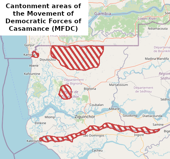
| 描述MFDCcontrol.png | Cantonment areas of the Movement of Democratic Forces of Casamance (MFDC), around 2017 |
| 日期 | |
| 來源 | 自己的作品, based on La frontière Sénégal-Gambie dans le contexte du conflit en Casamance : mobilités, flux transfrontaliers et géopolitique |
| 作者 | User:Borysk5 |
| 描寫MFDCcontrol.png |
本地圖以OpenStreetMap計畫資料建立,由社群收集。 此地圖可能不完整,也可能包含錯誤。別只用它當導航。 |
|||
| 日期 | (參見檔案歷史) | |||
| 來源 | openstreetmap.org | |||
| 創作作者 |
OpenStreetMap 貢獻者 |
|||
| 授權許可 (重用此檔案) |
OpenStreetMap的資料依據開放資料庫授權條款(細節)提供。圖磚採用創用CC姓名標示-相同方式分享 2.0(CC-BY-SA 2.0)條款授權。
此檔案採用共享創意 姓名標示-相同方式分享 2.0 通用版授權條款。
|
|||
| 地理參考 | 地理參考Wikimaps Warper中的地圖 如果不合適,請設定「warp_status = skip」為隱藏。 |
說明
添加單行說明來描述出檔案所代表的內容
在此檔案描寫的項目
描繪內容
10 6 2022
多媒體型式 繁體中文 (已轉換拼寫)
image/png
檔案歷史
點選日期/時間以檢視該時間的檔案版本。
| 日期/時間 | 縮圖 | 尺寸 | 用戶 | 備註 | |
|---|---|---|---|---|---|
| 目前 | 2022年6月10日 (五) 15:03 | | 543 × 506(183 KB) | Borysk5 | {{Information |Description=Cantonment areas of the Movement of Democratic Forces of Casamance (MFDC), around 2017 |Source={{own}}, based on [https://www.researchgate.net/figure/Forets-classees-et-zones-de-cantonnement-du-Mouvement-des-forces-democratiques-de-la_fig2_335528556 La frontière Sénégal-Gambie dans le contexte du conflit en Casamance : mobilités, flux transfrontaliers et géopolitique] |Date=2022-06-10 |Author=User:Borysk5 |Permission= |other_versions= }} {{OSM}} [[Category:Casam... |
檔案用途
沒有使用此檔案的頁面。
全域檔案使用狀況
以下其他 wiki 使用了這個檔案:
- en.wikipedia.org 的使用狀況
- hu.wikipedia.org 的使用狀況