File:Map_of_Sunda_and_Sahul.png
維基百科,自由的 encyclopedia
預覽大小:661 × 599 像素。 其他解析度:265 × 240 像素 | 530 × 480 像素 | 847 × 768 像素 | 1,111 × 1,007 像素。
原始檔案 (1,111 × 1,007 像素,檔案大小:208 KB,MIME 類型:image/png)

|
File:Map of Sunda and Sahul.svg是本檔案的向量版本。 如果品質不低,就應該優先使用該檔案,而非PNG檔案。
File:Map of Sunda and Sahul.png → File:Map of Sunda and Sahul.svg
更多資訊請參閱Help:SVG/zh。
|
 |
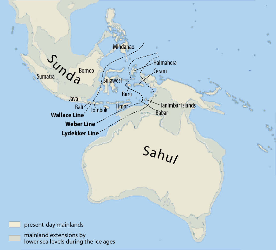
| 描述Map of Sunda and Sahul.png |
Deutsch: Karte von Sunda und Sahul sowie der Wallace-Linie, der Lydekker-Linie und der Weber-Linie.
Français : Carte de Sunda, de Sahul et de la ligne Wallace, de la ligne Lydekker et de la ligne Weber
Español: Mapa de Sunda y Sahul con la línea de Wallace, la línea de Lydekker y la línea de Weber.
|
| 日期 | |
| 來源 | Self made, using this map for the background |
| 作者 | Maximilian Dörrbecker (Chumwa) |
| 授權許可 (重用此檔案) |
我,本作品的著作權持有者,決定用以下授權條款發佈本作品: 此檔案採用共享創意 姓名標示-相同方式分享 3.0 未在地化版本授權條款。
Sie dürfen das Bild zu den folgenden Bedingungen nutzen:
|
| 其他版本 |
|


說明
添加單行說明來描述出檔案所代表的內容
Indonesia
十月 2007
檔案歷史
點選日期/時間以檢視該時間的檔案版本。
| 日期/時間 | 縮圖 | 尺寸 | 用戶 | 備註 | |
|---|---|---|---|---|---|
| 目前 | 2017年3月5日 (日) 08:07 | | 1,111 × 1,007(208 KB) | Chumwa | corr |
| 2009年7月25日 (六) 06:46 |  | 1,111 × 1,007(269 KB) | Chumwa | Inseln -> Islands | |
| 2009年7月25日 (六) 06:13 |  | 1,111 × 1,007(268 KB) | Chumwa | {{Information |Description= {{ de }}Karte von Sunda und Sahul sowie der Wallace-Linie, der Lydekker-Linie und der Weber-Linie. * Als Sahul wird die zusammenhängende Landmasse bezeichnet, die während der letzten Eiszeit aus Australien, der nordöstlich d |
檔案用途
全域檔案使用狀況
以下其他 wiki 使用了這個檔案:
- ar.wikipedia.org 的使用狀況
- ast.wikipedia.org 的使用狀況
- be.wikipedia.org 的使用狀況
- bg.wikipedia.org 的使用狀況
- bn.wikipedia.org 的使用狀況
- ca.wikipedia.org 的使用狀況
- cs.wikipedia.org 的使用狀況
- de.wikipedia.org 的使用狀況
- en.wikipedia.org 的使用狀況
- Dingo
- New Guinea singing dog
- List of lost lands
- Red-naped trogon
- Models of migration to the Philippines
- Denisovan
- Canis lupus dingo
- User:Cruickshanks/Sandbox
- User:Obsidian Soul/sandbox
- Wikipedia:Reference desk/Archives/Science/2011 May 15
- List of butterflies of the Philippines
- Wikipedia:Categories for discussion/Log/2015 June 26
- eo.wikipedia.org 的使用狀況
- es.wikipedia.org 的使用狀況
- fa.wikipedia.org 的使用狀況
- fi.wikipedia.org 的使用狀況
- fr.wikipedia.org 的使用狀況
- gl.wikipedia.org 的使用狀況
檢視此檔案的更多全域使用狀況。
詮釋資料
此檔案中包含擴展的資訊。這些資訊可能是由數位相機或掃描器在建立時或數位化過程中所加入。
如果此檔案的來源檔案已被修改,一些資訊在修改後的檔案中將不能完全反映出來。
| 水平解析度 | 39.37 dpc |
|---|---|
| 垂直解析度 | 39.37 dpc |
| 使用軟體 |