File:Sumatra_Volcanoes.png
維基百科,自由的 encyclopedia
此為最大尺寸。
Sumatra_Volcanoes.png (600 × 527 像素,檔案大小:141 KB,MIME 類型:image/png)
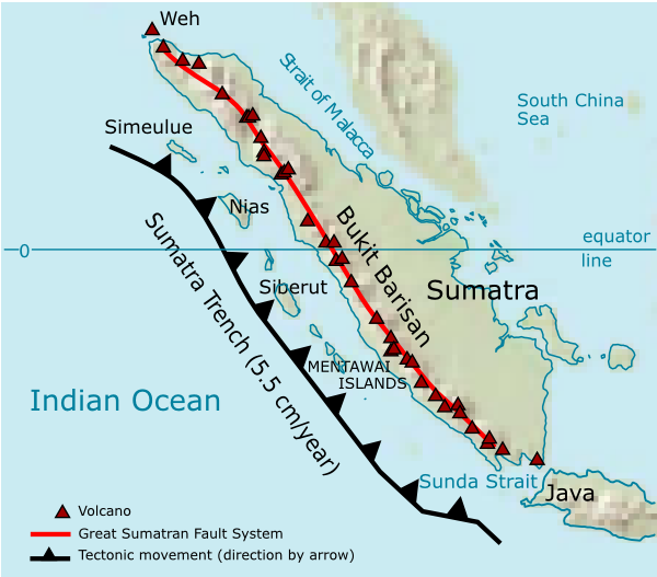
| 描述Sumatra Volcanoes.png | Volcanoes on Sumatra island. See en:List of volcanoes in Indonesia. | ||||||||
| 日期 | |||||||||
| 來源 | 自己的作品 | ||||||||
| 作者 | User:Indon (myself) | ||||||||
| 授權許可 (重用此檔案) |
我,本作品的著作權持有者,決定用以下授權條款發佈本作品:
您可以選擇您需要的授權條款。 |

Source of maps:
- Base map is a truncated public domain image: Image:Southeast asia.svg.
- Geological trench system is taken from Simoes, M., et al. (2004), The Sumatra subduction zone: A case for a locked fault zone extending into the mantle, J. of Geophysical Research, 109. DOI: 10.1029/2003JB002958.
- Volcanoes location was traced from en:Google Earth system.
說明
添加單行說明來描述出檔案所代表的內容
在此檔案描寫的項目
描繪內容
GNU自由文檔許可證1.2或更高版本 繁體中文 (已轉換拼寫)
2006
檔案歷史
點選日期/時間以檢視該時間的檔案版本。
| 日期/時間 | 縮圖 | 尺寸 | 用戶 | 備註 | |
|---|---|---|---|---|---|
| 目前 | 2006年12月28日 (四) 01:35 | | 600 × 527(141 KB) | Indon~commonswiki | {{Information |Description=Volcanoes on Sumatra island. See en:List of volcanoes in Indonesia. |Source=own work |Date=2006 |Author=User:Indon (myself) |Permission={{GFDL-self}} |other_versions= }} Source of maps: # Base map is a truncated public |
檔案用途
下列5個頁面有用到此檔案:
全域檔案使用狀況
以下其他 wiki 使用了這個檔案:
- ar.wikipedia.org 的使用狀況
- arz.wikipedia.org 的使用狀況
- ast.wikipedia.org 的使用狀況
- as.wikipedia.org 的使用狀況
- bg.wikipedia.org 的使用狀況
- bs.wikipedia.org 的使用狀況
- ca.wikipedia.org 的使用狀況
- ceb.wikipedia.org 的使用狀況
- ckb.wikipedia.org 的使用狀況
- cs.wikipedia.org 的使用狀況
- da.wikipedia.org 的使用狀況
- de.wikipedia.org 的使用狀況
- en.wikipedia.org 的使用狀況
- eo.wikipedia.org 的使用狀況
- es.wikipedia.org 的使用狀況
- fa.wikipedia.org 的使用狀況
- fi.wikipedia.org 的使用狀況
- fo.wikipedia.org 的使用狀況
- frr.wikipedia.org 的使用狀況
- fr.wikipedia.org 的使用狀況
- fy.wikipedia.org 的使用狀況
- ha.wikipedia.org 的使用狀況
- hi.wikipedia.org 的使用狀況
- id.wikipedia.org 的使用狀況
- it.wikipedia.org 的使用狀況
檢視此檔案的更多全域使用狀況。