File:ÖRF_2011.png
維基百科,自由的 encyclopedia
此為最大尺寸。
ÖRF_2011.png (790 × 439 像素,檔案大小:374 KB,MIME 類型:image/png)
摘要
| 描述ÖRF 2011.png |
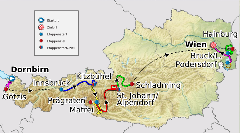
Deutsch: Verlauf der Österreich-Rundfahrt 2011
English: Route of the Tour of Austria 2011
Français : Parcours de la Tour d'Autriche 2011 |
| 日期 | 2011年五月20日 (原始上傳日期) |
| 來源 |
Transferred from de.wikipedia to Commons. |
| 作者 |
|
授權條款
我,本作品的著作權持有者,決定用以下授權條款發佈本作品:
此檔案採用共享創意 姓名標示-相同方式分享 3.0 未在地化版本授權條款。
- 您可以自由:
- 分享 – 複製、發佈和傳播本作品
- 重新修改 – 創作演繹作品
- 惟需遵照下列條件:
- 姓名標示 – 您必須指名出正確的製作者,和提供授權條款的連結,以及表示是否有對內容上做出變更。您可以用任何合理的方式來行動,但不得以任何方式表明授權條款是對您許可或是由您所使用。
- 相同方式分享 – 如果您利用本素材進行再混合、轉換或創作,您必須基於如同原先的相同或兼容的條款,來分布您的貢獻成品。

|
已授權您依據自由軟體基金會發行的無固定段落、封面文字和封底文字GNU自由文件授權條款1.2版或任意後續版本,對本檔進行複製、傳播和/或修改。該協議的副本列在GNU自由文件授權條款中。http://www.gnu.org/copyleft/fdl.htmlGFDLGNU Free Documentation Licensetruetrue |
您可以選擇您需要的授權條款。
原始上傳日誌
The original description page was here. All following user names refer to de.wikipedia.
- 2011-05-23 17:12 Maxxl2 801×445× (397530 bytes) {{Information |Beschreibung = |Quelle = |Urheber = |Datum = |Genehmigung = |Andere Versionen = |Anmerkungen = Typo beseitigt }}
- 2011-05-23 12:51 Maxxl2 800×445× (397397 bytes) {{Information |Beschreibung = |Quelle = |Urheber = |Datum = |Genehmigung = |Andere Versionen = |Anmerkungen = Typo beseitigt - Auflösung verbessert }}
- 2011-05-20 21:05 Maxxl2 500×278× (180848 bytes) {{Information |Beschreibung = Verlauf der Österreich-Rundfahrt 2011 |Quelle = http://www.oesterreich-rundfahrt.at/ |Urheber = [[Maxxl2]] unter Verwendung der Karten von [[Lencer]] und [[Uwe Dedering]] |Datum = 20.05.2011
This image is a derivative work of the following images:
- File:Austria_location_map.svg licensed with Cc-by-sa-3.0, GFDL
- 2008-09-11T16:25:48Z Lencer 1256x700 (164515 Bytes) {{Information |Description= |Source= |Date= |Author= |Permission= |other_versions= }}
- 2008-09-10T15:16:19Z Lencer 1256x700 (161047 Bytes) {{Information |Description= |Source= |Date= |Author= |Permission= |other_versions= }}
- 2008-07-18T11:34:43Z NordNordWest 1256x700 (152529 Bytes) {{Information |Description= {{de|Positionskarte von [[:de:Österreich|Österreich]]}} Quadratische Plattkarte, N-S-Streckung 150 %. Geographische Begrenzung der Karte: * N: 49.2° N * S: 46.3° N * W: 9.4° O * O: 17.2
- File:Austria_relief_location_map.jpg licensed with Cc-by-sa-3.0, GFDL
- 2010-06-28T09:14:18Z Uwe Dedering 1256x700 (692901 Bytes) very little border change
- 2010-04-26T12:24:59Z Uwe Dedering 1256x700 (692757 Bytes) rhine
- 2010-04-24T12:54:54Z Uwe Dedering 1256x700 (692681 Bytes) {{Information |Description={{en|1=Location map of [[:en:Austria|Austria]]}} Equirectangular projection, N/S stretching 150 %. Geographic limits of the map: * N: 49.2° N * S: 46.3° N * W: 9.4° E * E: 17.2° E
Uploaded with derivativeFX
說明
添加單行說明來描述出檔案所代表的內容
在此檔案描寫的項目
描繪內容
GNU自由文檔許可證1.2或更高版本 繁體中文 (已轉換拼寫)
共享創意署名-相同方式共享3.0Unported Chinese (Hong Kong) (已轉換拼寫)
20 5 2011
檔案歷史
點選日期/時間以檢視該時間的檔案版本。
| 日期/時間 | 縮圖 | 尺寸 | 用戶 | 備註 | |
|---|---|---|---|---|---|
| 目前 | 2011年7月8日 (五) 07:59 | | 790 × 439(374 KB) | MaxxL | Reverted to version as of 07:57, 8 July 2011 |
| 2011年7月8日 (五) 07:58 |  | 790 × 439(374 KB) | MaxxL | Reverted to version as of 21:14, 7 July 2011 | |
| 2011年7月8日 (五) 07:57 |  | 790 × 439(374 KB) | MaxxL | second effort | |
| 2011年7月7日 (四) 21:14 |  | 790 × 439(374 KB) | MaxxL | upgraded track | |
| 2011年5月29日 (日) 02:15 |  | 801 × 445(388 KB) | Saibo | 2011-05-23 17:12 Maxxl2 801×445× (397530 bytes) Typo beseitigt | |
| 2011年5月29日 (日) 02:14 |  | 800 × 445(388 KB) | Saibo | 2011-05-23 12:51 Maxxl2 800×445× (397397 bytes) Typo beseitigt - Auflösung verbessert | |
| 2011年5月29日 (日) 02:13 |  | 500 × 278(177 KB) | Saibo | 2011-05-20 21:05 Maxxl2 500×278× (180848 bytes) ''<nowiki>{{Information |Beschreibung = Verlauf der Österreich-Rundfahrt 2011 |Quelle = http://www.oesterreich-rundfahrt.at/ |Urheber = Maxxl2 unter Verwend |
檔案用途
沒有使用此檔案的頁面。
全域檔案使用狀況
以下其他 wiki 使用了這個檔案:
- de.wikipedia.org 的使用狀況
- en.wikipedia.org 的使用狀況
- es.wikipedia.org 的使用狀況
- fr.wikipedia.org 的使用狀況
- pt.wikipedia.org 的使用狀況
- ru.wikipedia.org 的使用狀況
- uk.wikipedia.org 的使用狀況