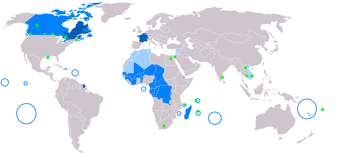
File:Map-Francophone_World.png
維基百科,自由的 encyclopedia
預覽大小:800 × 354 像素。 其他解析度:320 × 142 像素 | 640 × 283 像素 | 1,425 × 631 像素。
原始檔案 (1,425 × 631 像素,檔案大小:39 KB,MIME 類型:image/png)
摘要
| 描述Map-Francophone World.png |
English: Map of Francophone world.
Français : Carte du monde où on parle le français.
Русский: Карта франкоязычного мира.
Nederlands: Het Frans in de wereld.
Suomi: Maailmankartta ranskaa puhuvista maista.
Українська: Мапа франкомовного світу.
日本語: フランス語圏の地図。
中文:说法语的人在世界上的分布情况
Čeština: Mapa frankofonního světa
|
| Caption InfoField | English:
Français :
Español:
Deutsch:
Русский:
العربية:
Slovenčina:
Čeština:
Esperanto:
Italiano:
Magyar:
Nederlands:
Norsk bokmål:
Polski:
Português:
Română:
Suomi:
Svenska:
Türkçe:
Українська:
中文:
日本語: |
| 日期 | |
| 來源 |
Incomplete 本檔案衍生自: BlankMap-World.png: |
| 作者 |
|
授權條款
| Public domainPublic domainfalsefalse |
| 此作品已由其作者,Yug,釋出至公有領域。此授權條款在全世界均適用。 這可能在某些國家不合法,如果是的話: |
說明
添加單行說明來描述出檔案所代表的內容
在此檔案描寫的項目
描繪內容
著作權狀態 繁體中文 (已轉換拼寫)
保有知識產權並由其所有者公開於公有領域 繁體中文 (已轉換拼寫)
著作權持有者釋出至公有領域 繁體中文 (已轉換拼寫)
10 12 2005
多媒體型式 繁體中文 (已轉換拼寫)
image/png
檔案歷史
點選日期/時間以檢視該時間的檔案版本。
| 日期/時間 | 縮圖 | 尺寸 | 用戶 | 備註 | |
|---|---|---|---|---|---|
| 目前 | 2018年3月9日 (五) 20:20 | | 1,425 × 631(39 KB) | Maphobbyist | South Sudan border |
| 2018年1月23日 (二) 12:30 |  | 1,425 × 631(39 KB) | Maphobbyist | Sticking to sources. French is not the majority mother language in Gabon and Ivory coast and in its capital cities. | |
| 2017年4月19日 (三) 13:22 |  | 1,425 × 631(39 KB) | Sorkiv | The French language has become native to Gabon and Côte d'Ivoire (Abidjan, Yamoussoukro). | |
| 2015年5月7日 (四) 12:53 |  | 1,425 × 631(39 KB) | Zorion | From Hearst (Ontario) to Abitibi, it's a french-speaking zone + Anticosti added + remouved a part of New-Brunswick + francophone in Alberta are located in the Noth-West + Aroostook County in US | |
| 2014年12月11日 (四) 17:52 |  | 1,425 × 631(56 KB) | Maphobbyist | In Syria French is a secondary non-official language. | |
| 2014年12月11日 (四) 16:57 |  | 1,425 × 631(49 KB) | Maphobbyist | In New Caledonia, French is the sole official language, but it is the mother language of a minority. | |
| 2008年3月6日 (四) 17:13 |  | 1,425 × 631(32 KB) | Arctic.gnome | French is administrative in Canada and a secondary language in Andorra. I also added PEI and Manitoulin Island to Canada, and Saint Pierre, Miquelon and Sable islands around the Newfoundland coast. | |
| 2008年3月6日 (四) 17:09 |  | 1,425 × 631(50 KB) | Arctic.gnome | Reverted to version as of 20:37, 22 January 2007 | |
| 2008年3月6日 (四) 17:08 |  | 1,425 × 631(32 KB) | Arctic.gnome | == Summary == Map of Francophone world. Map made from Image:BlankMap-World.png '''English''' legends: {{legend|#0c5eb1|native language}} {{legend|#0080ff|administrative language}} {{legend|#9fceff|secondary or non-official langua | |
| 2007年1月22日 (一) 20:37 |  | 1,425 × 631(50 KB) | IAMTHEEGGMAN | Updating actual World Map and Adding Montenegro. |
檔案用途
沒有使用此檔案的頁面。
全域檔案使用狀況
以下其他 wiki 使用了這個檔案:
- de.wikipedia.org 的使用狀況
- en.wikipedia.org 的使用狀況
- fr.wikipedia.org 的使用狀況
- fr.wiktionary.org 的使用狀況
- he.wikivoyage.org 的使用狀況
- it.wikipedia.org 的使用狀況
- it.wiktionary.org 的使用狀況
- no.wiktionary.org 的使用狀況
- zh-min-nan.wikipedia.org 的使用狀況
詮釋資料
此檔案中包含擴展的資訊。這些資訊可能是由數位相機或掃描器在建立時或數位化過程中所加入。
如果此檔案的來源檔案已被修改,一些資訊在修改後的檔案中將不能完全反映出來。
| 水平解析度 | 37.8 dpc |
|---|---|
| 垂直解析度 | 37.8 dpc |