File:Map_of_Burzenland,_1959.jpg
維基百科,自由的 encyclopedia
預覽大小:367 × 599 像素。 其他解析度:147 × 240 像素 | 294 × 480 像素 | 470 × 768 像素 | 1,270 × 2,073 像素。
原始檔案 (1,270 × 2,073 像素,檔案大小:1.99 MB,MIME 類型:image/jpeg)
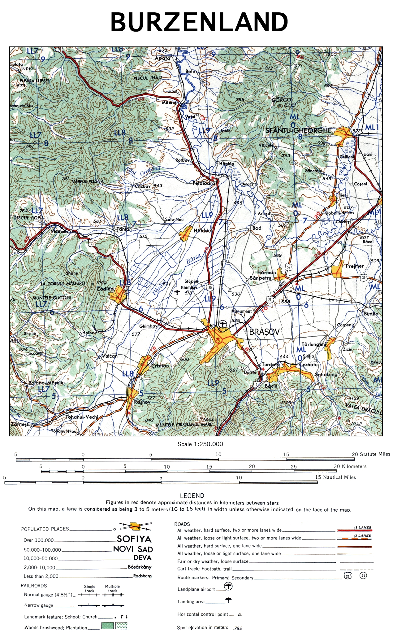
| 描述Map of Burzenland, 1959.jpg | The map of Burzenland, Romania. | |||
| 日期 | ||||
| 來源 | University of Texas Libraries | |||
| 作者 | US Army Map Service, Corps of Engineers | |||
| 其他版本 |
|

| Public domainPublic domainfalsefalse |
This image or file is a work of a U.S. Army Corps of Engineers soldier or employee, taken or made as part of that person's official duties. As a work of the U.S. federal government, the image is in the public domain.
English | italiano | Nederlands | پښتو | русский | sicilianu | slovenščina | Türkçe | українська | +/− |
說明
添加單行說明來描述出檔案所代表的內容
在此檔案描寫的項目
描繪內容
1959
檔案歷史
點選日期/時間以檢視該時間的檔案版本。
| 日期/時間 | 縮圖 | 尺寸 | 用戶 | 備註 | |
|---|---|---|---|---|---|
| 目前 | 2009年11月12日 (四) 21:48 | | 1,270 × 2,073(1.99 MB) | Alex:D | {{Information |Description= The map of Burzenland, Romania. |Source= [http://www.lib.utexas.edu/maps/ams/western_europe/ University of Texas Libraries] |Date= 1959 |Author= US Army Map Service, Corps of Engineers |Permission= |other_versions={{ExtractedFr |
檔案用途
下列頁面有用到此檔案:
全域檔案使用狀況
以下其他 wiki 使用了這個檔案:
- ca.wikipedia.org 的使用狀況
- cs.wikipedia.org 的使用狀況
- da.wikipedia.org 的使用狀況
- de.wikipedia.org 的使用狀況
- en.wikipedia.org 的使用狀況
- es.wikipedia.org 的使用狀況
- fr.wikipedia.org 的使用狀況
- hu.wikipedia.org 的使用狀況
- it.wikipedia.org 的使用狀況
- ja.wikipedia.org 的使用狀況
- pl.wikipedia.org 的使用狀況
- ru.wikipedia.org 的使用狀況
- sk.wikipedia.org 的使用狀況
詮釋資料
此檔案中包含擴展的資訊。這些資訊可能是由數位相機或掃描器在建立時或數位化過程中所加入。
如果此檔案的來源檔案已被修改,一些資訊在修改後的檔案中將不能完全反映出來。
| _error | 0 |
|---|