File:Southern_Leyte_mudslide_2006_pic01.jpg
維基百科,自由的 encyclopedia
預覽大小:800 × 531 像素。 其他解析度:320 × 212 像素 | 640 × 425 像素 | 1,024 × 680 像素 | 1,280 × 850 像素 | 2,560 × 1,700 像素 | 3,225 × 2,141 像素。
原始檔案 (3,225 × 2,141 像素,檔案大小:4.61 MB,MIME 類型:image/jpeg)
| 描述Southern Leyte mudslide 2006 pic01.jpg |
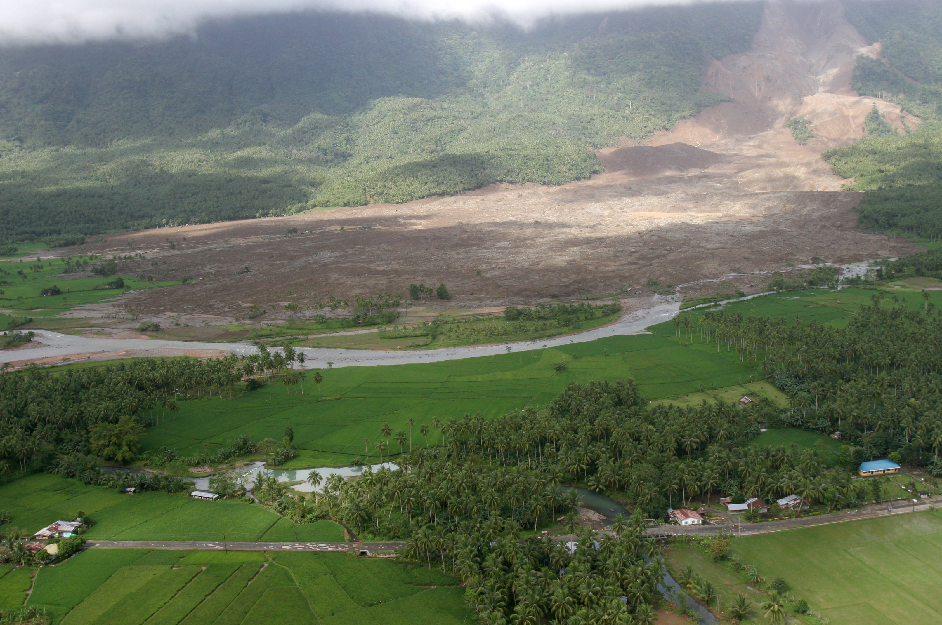
English: 060219-M-8084P-001 Saint Bernard, Republic of the Philippines (Feb. 19, 2006) - An aerial view of the mudslide, which destroyed the town of Guinsahugon the morning of Feb. 17. Guinsahugon is located in the southern part of the island of Leyte in the Philippines. The photo was taken from a CH-46E Sea Knight which was being flown to Guinsahugon to deliver relief supplies. The helicopter is from the 31st Marine Expeditionary Unit's aviation combat element Marine Medium Helicopter Squadron 262 (Reinforced). The MEU, based out of Okinawa, Japan, is deployed to the Philippines as part of the Forward Deployed Amphibious Ready Group (ARG) based out of Sasebo, Japan and was in the Philippines to take part in exercise Balikatan 2006 before responding to a request for aid by the Philippine government. U.S. Marine Corps photo by Lance Cpl. Raymond D. Petersen III (RELEASED)
Deutsch: Schlammlawine |
|||||||
| 日期 | ||||||||
| 來源 | http://www.navy.mil/view_image.asp?id=32089 | |||||||
| 作者 | Raymond D. Petersen III | |||||||
| 授權許可 (重用此檔案) |
|
|||||||

說明
添加單行說明來描述出檔案所代表的內容
Aerial view of the mudslide, which destroyed the town of Guinsahugon, on Feb. 17, 2006.
在此檔案描寫的項目
描繪內容
19 2 2006
攝影器材 繁體中文 (已轉換拼寫)
佳能 EOS 20D 中文 (已轉換拼寫)
檔案歷史
點選日期/時間以檢視該時間的檔案版本。
| 日期/時間 | 縮圖 | 尺寸 | 用戶 | 備註 | |
|---|---|---|---|---|---|
| 目前 | 2006年2月20日 (一) 12:42 | | 3,225 × 2,141(4.61 MB) | Stefan Kühn | {{PD-USGov-Military-Navy}} Source: http://www.navy.mil/view_single.asp?id=32089 060219-M-8084P-001 Saint Bernard, Republic of the Philippines (Feb. 19, 2006) - An aerial view of the mudslide, which destroyed the town of Guinsahugon the morning of Feb. 1 |
檔案用途
下列2個頁面有用到此檔案:
全域檔案使用狀況
以下其他 wiki 使用了這個檔案:
- ceb.wikipedia.org 的使用狀況
- de.wikipedia.org 的使用狀況
- en.wikipedia.org 的使用狀況
- es.wikipedia.org 的使用狀況
- fi.wikipedia.org 的使用狀況
- fr.wikipedia.org 的使用狀況
- hi.wikipedia.org 的使用狀況
- id.wikipedia.org 的使用狀況
- it.wikipedia.org 的使用狀況
- ja.wikipedia.org 的使用狀況
- ka.wikipedia.org 的使用狀況
- mk.wikipedia.org 的使用狀況
- ru.wikipedia.org 的使用狀況
- sv.wikipedia.org 的使用狀況
- tl.wikipedia.org 的使用狀況
- zh-classical.wikipedia.org 的使用狀況
- zh-min-nan.wikipedia.org 的使用狀況
詮釋資料
此檔案中包含擴展的資訊。這些資訊可能是由數位相機或掃描器在建立時或數位化過程中所加入。
如果此檔案的來源檔案已被修改,一些資訊在修改後的檔案中將不能完全反映出來。
| 影像標題 |
|
|---|---|
| 相機製造商 | Canon |
| 相機型號 | Canon EOS 20D |
| 作者 | Lance Cpl. Raymond Petersen III |
| 曝光時間 | 1/400 秒 (0.0025) |
| 光圈值 | f/8 |
| ISO 速率 | 200 |
| 資料產生的日期時間 | 2006年2月19日 (日) 10:15 |
| 焦距 | 20 mm |
| 顯示的城市 | Camp Foster |
| 簡稱 | 060219-M-8084P-001 |
| 製作/提供者 | 31st MEU |
| 來源 | Canon EOS 20D |
| 標題 | U.S. Military responds to Philippine landslide relief effort |
| 版權所有人 | Public Domain |
| 方位 | 標準 |
| 水平解析度 | 72 dpi |
| 垂直解析度 | 72 dpi |
| 使用軟體 | Adobe Photoshop CS2 Macintosh |
| 檔案修改日期時間 | 2006年2月19日 (日) 19:49 |
| 亮度與彩度位置 | 同時取樣 |
| 曝光模式 | 光圈優先 |
| Exif 版本 | 2.21 |
| 數位化的日期時間 | 2006年2月19日 (日) 10:15 |
| 每像素內含 |
|
| APEX 快門速度 | 8.6438598632812 |
| APEX 光圈 | 6 |
| APEX 曝光補償 | −0.33333333333333 |
| 測光模式 | 部分 |
| 閃光燈 | 閃光燈未開啟、強制閃光燈關閉 |
| 支援的 Flashpix 版本 | 1 |
| 色彩空間 | sRGB |
| X 軸焦平面解析度 | 3,959.3220338983 |
| Y 軸焦平面解析度 | 3,959.3220338983 |
| 焦平面解析度單位 | 英寸 |
| 自訂影像處理 | 一般程序 |
| 曝光模式 | 自動曝光 |
| 白平衡 | 自動白平衡 |
| 場景拍攝類型 | 標準 |
| IIM 版本 | 3 |
| 顯示省或州 | Okinawa |
| 顯示國家 | Japan |
| 分類 | M |
| 補充分類 |
|
| 關鍵字 |
|
| 作家 | LCpl Petersen |
| 特別說明 | Credit as U.S. Marine Corps photo by Lance Cpl. Raymond Petersen III |
| 原始傳輸位置代碼 | 31 MEU |
| 支援的 Flashpix 版本 | 1 |
| 影像寬度 | 3,225 px |
| 影像高度 | 2,141 px |
| 詮釋資料最後修改日期 | 2006年2月19日 (日) 14:49 |